Best Dispersed Camping near Clarkesville, GA

Dispersed camping opportunities around Clarkesville, Georgia include several primitive sites within Chattahoochee National Forest. Free camping areas such as Corbin Creek Tray Mountain, Indian Grave Gap, and Dicks Creek Falls provide backcountry experiences on public lands without fees or reservations. Most sites are located along forest service roads and near water features, with additional options at High Shoals Falls Trail, Cowrock Mountain, and Soggy Boot Campground. Several sites across the state line in South Carolina, including Miller Branch Camp, Falls Creek, and Blackwell Bridge, offer alternative locations within driving distance.

Vehicle requirements vary significantly across sites, with many areas requiring high-clearance or 4WD vehicles. Corbin Creek features rough switchbacks where "moderate clearance vehicles" are necessary, while Indian Grave Gap accommodates multiple vehicles with creek access. The majority of these dispersed sites provide no amenities—no restrooms, drinking water, or trash service. Fire rings constructed from rocks are common at established sites, though fire bans may apply seasonally. Roads accessing these areas are typically unpaved, ranging from basic dirt tracks to rocky forest trails with occasional water crossings.

The natural setting provides the primary attraction at these primitive sites, particularly proximity to creeks, waterfalls, and mountain views. Campers highlight the seclusion and backcountry feel despite relatively close access to towns like Helen and Hiawassee. At High Shoals Falls, visitors can enjoy "a 2.4 mile round trip hike with primitive camping alongside High Shoals Creek" and access to two waterfalls. Sites vary in size, with Indian Grave Gap offering larger clearings where "each site is huge" and can accommodate groups. Soggy Boot Campground features "a massive clearing where you could easily fit 8 cars." Seasonal conditions affect accessibility, with some campers noting that "after a storm, expect a lot of wet puddles and soggy ground" at sites like Blackwell Bridge.

Best Dispersed Sites Near Clarkesville, Georgia (42)

    1. Corbin Creek Tray Mountain

    3 Reviews
    Helen, GA
    17 miles
    Website
    +1 (706) 745-6928

    "A 4wd with moderate clearance is helpful. Wonderful stream running through the campsite."

    "This is by far my favorite place we’ve been off grid camping. It’s more Jeep friendly than full size vehicles, to get a spot down by the creek."

    2. Indian Grave Gap Campsite

    2 Reviews
    Helen, GA
    16 miles
    Website

    "All three have creek access. We picked the single on the other side. Not a lot of flat ground options. Each site is huge."

    "If you’re anywhere near Helen, GA on an ADV Bike, this summit is for you. There are three routes up the mountain so you never have to double back."

    3. Miller Branch Camp

    1 Review
    Hiawassee, GA
    18 miles
    Website
    +1 (706) 745-6928

    4. High Shoals Falls Trail Dispersed

    1 Review
    Helen, GA
    18 miles
    Website

    "A relatively moderate 2.4 mile (round trip) hike with primitive camping/ backpacking campsites alongside High Shoals Creek."

    5. Cowrock Mountain

    2 Reviews
    Chattahoochee-Oconee National Forests, GA
    20 miles

    "Dispersed camp sites at or near the summit of Cowrock Mountain offer wonderfully shaded spots with long range views of the Blue Ridge."

    "This section of the AT isn’t easy breezy, but it levels out and the trees thin out on the mountain ridges to relatively open, flat land for camping Ran into som AT’ers packing up for the morning."

    6. Soggy Boot Campground

    5 Reviews
    Rabun Gap, GA
    24 miles

    "We came looking for this campsite past dark and after a half hour of driving on a gravel road we gave up searching and just parked on the side of the road for the night."

    "Is a little confusing to find but just when you question if you’re heading to the right place, you’re greeted with a fork and small trail down to a massive clearing."

    7. Falls Creek

    2 Reviews
    Long Creek, SC
    22 miles
    Website
    +1 (864) 638-9568

    "Decent site(s) near chatooga river. Moderate clearance vehicle required, (or hike it)."

    8. Dicks Creek Falls Campsites off Main Road

    1 Review
    Suches, GA
    24 miles

    "They have a couple closer to water but most are more remote. There is a 3 mile long dirt road to travel on."

    9. Blue Valley Dispersed Camping

    8 Reviews
    Highlands, NC
    33 miles
    Website

    "Location is actually about 1.5. Miles further than shown on map. Just keep going. Stayed for a week. About 7 campsites with fire rings. Great trails and people camping near were respectful."

    "Almost all near a creek of some sort. Hiking trails near by. No facilities. Room for larger groups ~40 people max for the biggest site ~6 for the smallest"

    10. Blackwell Bridge - Dispersed Camping

    2 Reviews
    Long Creek, SC
    25 miles
    Website
    +1 (864) 638-9568

    "Access is rough, (moderate clearance vehicles required). Also, as courtesy - cruise the bridge and see if people are down there first, (both sides). Sweet backcountry spot!"

Show More
Showing results 1-10 of 42 campgrounds

2025 Detourist Giveaway

Presented byToyota Trucks

Review Campgrounds. Win Prizes.

Enter to Win


Dispersed Camping Reviews near Clarkesville, GA

59 Reviews of 42 Clarkesville Campgrounds


  • Asher K.The Dyrt PRO User
    Jul. 10, 2019

    Glen Falls Backcountry Campground

    Ranger Review: Red Ledge Free Rein Jacket at Glen Falls Backcountry
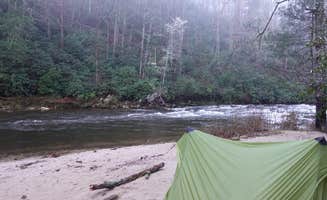
    Campground Review:

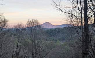
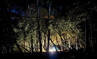
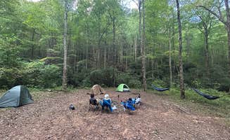
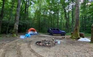
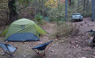
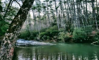
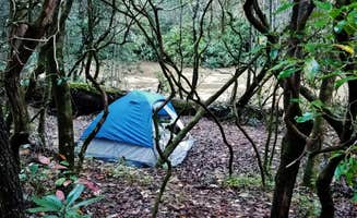
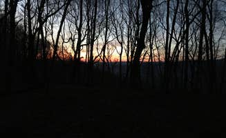
    There are two ways to access this campsite and one definitely requires significantly more sweat (that’s the route we took). The backcountry site is located near the far trailhead at Glen Falls located at the end of a forestry road. We hiked in from the trailhead that most people use to access the falls and continued down the trail past the typical turnaround point until you reach the bottom of the valley. The site is on the nicer side for a backcountry campground as it is level and has multiple areas for tents along with a large fire pit surrounded by logs for sitting on. The main advantage of this site over others in the area is that it is located on the inside of a curve in the river so the creek surrounds almost the entire site giving easy access to water and a relaxing sound to help you sleep at night. The hike down from the upper trailhead is relatively steep and involves going down many (many) stairs but is well worth it for the views of Glen Falls. This is a well-traveled and also well cared for route and we saw many other hikers while we were there. However, most people do not make it all the way down to this site so you will most likely find a significant amount of privacy if you plan on camping here. Since it is National Forest you will have no issues with camping just make sure to follow leave no trace practice and keep your fire under control. I would also highly recommend a dip in the cool waters to help with the heat during the middle of the summer. Overall, this is a beautiful secluded campsite very close to Highlands that provides both tranquility and also some strenuous hiking.

    ...........................

    ****Product Review:** **

    As a Ranger for The Dyrt, I get to test products while out adventuring. At this campground, I stayed dry using the Red Ledge Free Rein Jacket. After multiple rainy hikes and wet campground days some of my favorite features are:

    1. Dryness (obviously): Although it is the main purpose of a raincoat I still want to mention that this design is highly effective at keeping you dry. Not only is the material incredibly water-resistant and all seams are well sealed but it also has a dual closure system in the front to keep every last drop of water away from your body. I also know that this effectiveness will last since my wife has been using a Red Ledge raincoat for many years and only recently did it need a fresh waterproofing treatment. The small touches like a multi-cinching hood and velcro wrist straps make this an incredibly effective raincoat.
    2. Breathability: Where I am hiking in the south breathability is just as important as waterproofing since the heat will often cause you to become wetter from sweat than anything the rain can do. I found that this raincoat although still being hot was significantly more breathable than others I have used with the same rain protection. It has huge armpit zipper openings and several large mesh pockets that can be opened to increase airflow. The only negative I found was that the sizes for men run slightly smaller than usual so the tightness decreased airflow. However, this can be easily solved by getting a size larger than your usual. 
    3. Color Options: One of the things that often frustrates me about men's hiking clothing and gear is that the colors are typically boring and flat. They stick to dull greens and blues or grays and blacks. But not these raincoats! They come in bright reds and greens and many other color options to fit your individual personality. This was a big plus for me and is important if you want to be seen while hiking in areas that allow hunting or don't want to get lost from your hiking partner in a torrential downpour. 

    Overall, for the very reasonable price of these raincoats, they are incredibly effective and comfortable and I would highly recommend seriously considering them for your next raincoat purchase.

  • Sara S.The Dyrt PRO User
    Mar. 22, 2025

    Mountain Rest Mountain Top

    Great but lower your expectations

    We arrived pretty late, close to midnight after hitting a lot of traffic traveling from Fl. The coordinates took us directly here, and upon first arriving we did see a campsite to the left which was being used. Continuing on for about another twenty minutes down a one-way gravel road we did not see anymore sites until the end of the road which has a beautiful sunrise view. There are hundreds of downed trees, I am assuming from Hurricane Helene. Which were chopped up, perfect for a firering.

    We went almost to the end of the road before turning around and just pulling over onto a little 'shoulder' to set up the tent for the night.

    Pros- Dead silent and relaxing Great view of the stars during early spring/late winter

    Cons- Not car accessible (road is narrow and very bumpy. 4x4 recommended but I made it down in a 2x4 fullsize pickup) Have not seen nor heard any creek despite one being in the photos.

    Definitely would come back

  • Myron C.The Dyrt PRO User
    Apr. 27, 2021

    Siler Bald Trail Shelter TR 373

    Trail Shelter along the Appalachian Trail

    Siler Bald is not to be confused with Silers Bald, which borders the NC/TN state line in the Great Smoky Mountains National Park. Siler Bald is actually in the Nantahala National Forest and is close to Wayah Bald along the Appalachian Trail. The shelter is aptly named after the adjacent mountain bald. I first went to Siler Bald many years ago but did not go to the trail shelter. This second time, I did go to the trail shelter, which is about nine-tenths of a mile past the Siler Bald summit if you are hiking north on the Appalachian Trail. If you are hiking from Wayah Bald, it is a little over three and a half miles. Since this is a trail shelter, it does not have electrical hookups. You will need to take a water filtration system for fresh water. Instead of searching for firewood, we used my old Coleman stove for dinner. Surprisingly, there were no other groups in the shelter the night we stayed there. The best things about this trail shelter are its proximity to the Appalachian Trail, the quietness you’ll experience since it is away from major highways, and its proximity to the Siler Bald summit. The summit provides a fantastic 360 degree view since it is a grassy bald, but it is a steep climb from the base to the summit. This is not an RV campground, and you do have to pack everything in(and out). You cannot go to the store to get supplies without hiking a long way, so be prepared. Overall, I loved it because of its peace and solitude.

  • William S.
    Sep. 25, 2021

    Albert Mountain Firetower Dispersed Campsite

    This one's for the hikers

    You can access this campsite by various means, but do your research and save yourself as many steps, because make no mistake, this is a serious hiking trail (a mile to a mile and a half, depending on route) up to the Fire Tower. 

    Part of the Appalachian Train, once you park your car or hike in, you'll make your way uphill over crude-cut rocks, tree roots, and muddy, narrow paths. Hiking poles are strongly recommended. The path down is just as treacherous as the path up, as moisture from the mountain drips down over craggy footholds. 

    While the path is popular with hikers, anyone camping should consider using a very small pack, especially since some of the trails have nothing but a chasm on one side. 

    Once you make it to the Fire Tower, however, all is forgiven. The site from the bottom is breathtaking, and you can see, well, forever. Heading up the tower (the very top is closed to visitors and mothballed), you get an almost full 360º panorama of the surrounding valleys and mountains. 

    The camp site itself is very rustic, no amenities other than a rock fire ring, and does not face the vistas. There's a weak LTE signal at the top, but be prepared to lose your signal along the way.

    Side note: I came through the Coweeta Hydrological Laboratory, which has numerous signs posted that you cannot camp there. However, it's part of the larger National Forest and it's not exactly clear where camping begins to be allowed, as there were several rustic sites along the trail at the upper end.

    If you do come driving through the Coweeta Hydrological Laboratory path, be prepared for narrow, steep gravel lanes. And keep in mind that if you do park your car on one of the (few) spaces available, you're going to be very far from it, and the site didn't appear to be patrolled in any way.

  • R
    Aug. 22, 2020

    Blue Valley Dispersed Camping

    Very nice camping and good trials.

    . Location is actually about 1.5. Miles further than shown on map. Just keep going. Stayed for a week. About 7 campsites with fire rings. Great trails and people camping near were respectful. Recommend.

  • CThe Dyrt PRO User
    Aug. 12, 2024

    Mountain Rest Mountain Top

    Hilltop camping with hiking trails

    Great spot with room to turn around. Shaded and at trailhead of a trail down to creek and near a second trail to a waterfall. Had a few people during the day but evenings were totally quiet. A bit of extra vehicle clearance is helpful...slow and steady gets you to a great spot. No services here but good dispersed spot.

  • CThe Dyrt PRO User
    Jul. 30, 2018

    Unicoi Gap Dispersed

    Helen Hideaway

    Free dispersed primitive camping minutes from Helen Ga and local wineries. Great spot next to the creek. Quiet and any potential neighbors are far enough away that you have total privacy

  • B
    Apr. 21, 2024

    Jones Creek Dispersed Campground

    Beautiful but popular

    Dont park where the map tells you, you can drive to the locations on a decent narrow dirt road.

    When we first arrived, the camp site we chose was on the river, but also off the main road. This area seems to be popular for local dirt bikers, but we seen people fishing and relaxing all the same.

    I would have gave 5 stars, but these sites are well used and has years of careless debris around. We also heard some folks shooting guns( in the distance), which isn’t a problem for us, but reduced the relaxing nature of the visit with all this combined.

    This river is amazing, low current makes its easy to walk in and there are a few little water falls we enjoyed hanging on for a bit.

  • Robert N.The Dyrt PRO User
    Sep. 9, 2023

    Panther Top Dispersed Site

    Panther Top Dispersed

    Great spot right on the little lake. You can hear the gun range from the Camp Spot, but it is barely noticeable. There are two main spots right on the lake that are set up for tent camping. My overland rig fit in the small parking area fine, but I had to find a few rocks to level my truck so the rooftop tent was level. It is obviously a spot that locals come to party on the weekends but I had no issues. There looks like there are only 2 primary camping spots with fire rings and tent pads. My spot had a picnic table and two tent pads, a pole for your lantern and was just feet from the lake. Lots of fish jumping and I caught a 1 pound large mouth bass on a silver spinning lure. Over all a great spot. No bugs, but you will likely need to bring firewood, as all of the fallen trees had been scavenged. Since there are only two spot, definitely have a backup plan, especially on the weekends.


Guide to Clarkesville

Dispersed camping near Clarkesville, Georgia offers access to the southern end of the Blue Ridge Mountains where elevations range from 1,200 to 4,700 feet. The Chattahoochee National Forest sites typically feature a mix of hardwood forest and stream access, with seasonal temperature variations bringing warm 70-85°F summer days and cooler 40-60°F spring and fall conditions. Sites are generally situated between 30-90 minutes from town on unpaved roads with varying degrees of maintenance.

What to do

Stargazing opportunities: Tray Mountain area sits within one of north Georgia's few dark sky zones. According to a camper at Corbin Creek Tray Mountain, it's "worth it if you're into astrophotography as all of tray mountain sits within the few dark areas within north Georgia."

Waterfall hiking: Multiple sites provide access to cascades within walking distance. At High Shoals Falls Trail Dispersed, visitors can "hike in style camp with the convenience of having your vehicle" with access to "2 beautiful Georgia waterfalls, Blue Hole Falls and High Shoals Falls."

Mountain biking: Forest service roads offer technical riding opportunities for adventure motorcyclists. One rider notes Indian Grave Gap is ideal "if you're anywhere near Helen, GA on an ADV Bike" since "there are three routes up the mountain so you never have to double back."

Fishing access: Many sites border streams with fishing potential. While conditions vary seasonally, most creek-side sites provide direct water access. Blackwell Bridge offers "a great destination for fishing," though campers should note water conditions can be affected by recent rainfall.

What campers like

Stream-side camping: The sound of flowing water is consistently mentioned as a highlight. At Soggy Boot Campground, visitors appreciate that "to get to the site you drive or walk through the river and end up in a large group site right by a small waterfall." Another camper notes, "There's a very flat area, a fire pit, and creek surrounded by forest and mountains."

Seclusion despite proximity: Many sites offer privacy while remaining relatively accessible. A camper at Falls Creek described it as a "nice secluded spot" with "room for two vehicles and multiple tent spots" that's "very secluded and fairly level."

Group-friendly clearings: Several sites accommodate larger gatherings. The largest site at Soggy Boot is described as "a massive clearing where you could easily fit 8 cars" with plenty of space for groups to spread out.

Trail connections: Direct access to hiking paths is valued by many campers. Blue Valley Dispersed Camping features "trailhead leads to waterfalls" and multiple reviewers note the convenience of hiking directly from camp.

What you should know

Vehicle considerations: Access to many sites requires appropriate vehicles. At Corbin Creek Tray Mountain, one camper notes, "It's more Jeep friendly than full size vehicles, to get a spot down by the creek. But it is possible to get a full size 4*4 truck down the switch back."

Weather impacts: Seasonal conditions significantly affect site usability. After heavy rain, some sites become problematic. At Blackwell Bridge, a camper warns that "if you camp there after a storm like I did, expect a lot of wet puddles and soggy ground."

Finding sites: Many areas lack clear signage or directions. For Soggy Boot Campground, one camper advises: "The best way to find this location is to put into the GPS the name of the nearby retreat center called 'Ramah Darom'. Once you get to the entrance keep continuing up the mountain."

Variable cell service: Most dispersed sites have little to no connectivity. Prepare offline maps and directions before leaving towns like Clarkesville, Helen or Hiawassee where signal is reliable.

Tips for camping with families

Multi-tent sites: Several locations accommodate family groupings with multiple tents. At Indian Grave Gap Campsite, one camper reports, "Three campsites in the immediate area. Two are on one side of the road. You have to cross thru one to get to the other. All three have creek access."

Stream exploration: Creek-adjacent sites provide natural play areas. Soggy Boot Campground offers opportunities to "hike up or down the stream to get to other beautiful small falls that are perfect for swimming in during the hot summers."

Limited emergency access: Most sites require 30+ minutes to reach medical facilities. Pack appropriate first aid supplies and emergency equipment, especially for families with children.

Weekend crowds: Popular sites fill quickly during peak seasons. As one camper at Dicks Creek Falls noted, "There is only 5 or 6 spots available for first come first serve camping... It was over full last time I was there summer of 2024."

Tips from RVers

Size restrictions: Most dispersed sites accommodate smaller RVs only. At Blue Valley Dispersed Camping, a camper advises, "I would be a bit concerned with larger rigs on the small road but small RVs or tents are great."

Road conditions: Forest service roads present challenges for larger vehicles. One Blue Valley visitor explains, "When I arrived the pavement ended and continued onward a very primitive gravel road. Pretty rough in some places and very narrow, let's just say I wouldn't want to end up encountering another car."

Leveling requirements: Many sites require significant leveling for RVs. Campers note the need for leveling blocks and stabilizers due to uneven terrain at most free camping sites near Clarkesville.

Limited turnaround space: Forest roads often lack adequate turning areas for larger vehicles. Scout ahead or research thoroughly before attempting access with anything larger than a small trailer or Class B campervan.

Frequently Asked Questions

Which is the most popular dispersed campsite near Clarkesville, GA?

According to TheDyrt.com, the most popular dispersed campground near Clarkesville, GA is Corbin Creek Tray Mountain with a 5-star rating from 3 reviews.

What is the best site to find dispersed camping near Clarkesville, GA?

TheDyrt.com has all 42 dispersed camping locations near Clarkesville, GA, with real photos and reviews from campers.