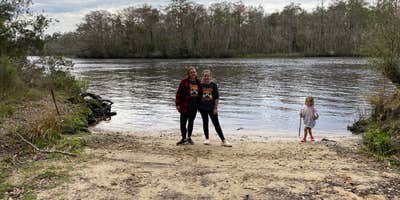
Tate's Hell State Forest encompasses Loop Road Campsite, a drive-in campground where electric, water, and sewer hookups are available at select sites. Only one site on the property has water access, while electricity varies by location. The single access road leads to forested sites near Womack Creek, with a boat ramp providing direct water access for fishing.
The facility includes a small restroom and picnic tables, with ongoing upgrades to site amenities. Campers stay on a single loop road with no through traffic, creating minimal disturbance from passing vehicles. For those planning extended stays in the region, camping near Tate's Hell State Forest offers additional options within the 202,000-acre forest system.
Description
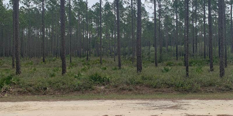
The Womack Creek Primitive Campsites are in Tates Hell State Forest (Franklin and Liberty Counties), about 10 miles southwest of Sopchoppy, FL. There are a total of six tent or RV accessible primitive campsites available in separate locations; one at Loop Road, one at Nicks Road Landing and four at Log Cabin Road. None of these sites have electricity, water, or restrooms. The Loop Road site has a boat launch, Nicks Road Landing site has a creek in behind the campsite and at the Log Cabin Road site there is a large area with river launch access. Recreational activities featured here are: fishing, canoeing, hiking, picnicking, bird watching, wildlife viewing and photography.
No water at campsite.
Warning 1 Alert is In Effect
There is 1 alert for this campground. Camp safely!
Warning 1 Alert is In Effect
There is 1 alert for this campground. Camp safely!
The Florida Forest Service will close all campgrounds and recreation areas on State Forests if the county where the State Forest is located is placed under a Tropical Storm or Hurricane WARNING by the National Weather Service. Reservations will be automatically refunded for closures related to tropical weather.
RV Road Trip Guides

Map & DirectionsWomack Creek Primitive Campsites – Loop Road Campsite – Tate’s Hell State Forest is located in Florida near Sopchoppy
Directions
**GPS Info** 23 Log Cabin: 30.0324 -84.5952 24 Log Cabin: 30.0302 -84.5923 25 Log Cabin: 30.0271 -84.5872 26 Log Cabin: 30.0261 -84.5862 27 Nick’s Road: 30.0141 -84.5768 28 Loop Road: 29.9898 -84.5350 23, 24, 25 and 26 Log Cabin campsites: From CR 67, turn onto Short Road and travel about 0.8 mile; turn second left (onto Forest Road 223) and travel about 0.1 mile; then turn right onto Log Cabin Road. 23 and 24 Log Cabin campsites are 0.8 mile ahead on your left; 25 and 26 Log Cabin campsites are 1.5 miles ahead on your left. 27 Nick’s Road: From CR 67, turn onto Rock Landing Road heading east and travel about 2.3 miles; turn third left (onto Jeff Sanders Road) and travel about 1.2 miles; turn left onto Nick’s Road. The campsite is about 1.7 miles ahead at the end of the road. 28 Loop Road: From CR 67, turn onto Rock Landing Road heading east and travel about 2.3 miles; turn third left (onto Jeff Sanders Road) and travel about 2.1 miles; turn right onto Forest Road 233. The campsite is about 0.5 mile ahead.
Address
Nicks, Rd., Log Cabin, Loop Rd
Carrabelle, FL 32322
Coordinates
29.990819462172304 N
84.53582929311708 W
Connectivity
 T-MobileNo Coverage
 VerizonLTESome Coverage
 AT&T5GGood Coverage
Connectivity
- T-MobileNo Coverage
- VerizonLTESome Coverage
- AT&T5GGood Coverage
Access
- Drive-InPark next to your site
Site Types
- Tent Sites
- RV Sites
Features
For Campers
- Picnic Table
- Reservable
- Electric Hookups
- Pets
- Fires
For Vehicles
- Sewer Hookups
- Water Hookups
- 30 Amp Hookups
- 50 Amp Hookups


