Within White River National Forest, Marvine Campground provides access to the Flat Tops Wilderness through nearby trailheads. The US Forest Service manages this established campground with sites accommodating RVs up to 40 feet, though access roads can be rough. Water hookups are available at some sites, along with drinking water, restrooms, and trash service.
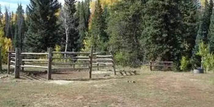
The campground serves as a staging area for pack rides into the wilderness, with horse corrals available at the trailhead for an additional fee. Sites are spread through forested terrain near water features, and the facility typically runs at less than half capacity during the season. East Marvine sits just north for campers wanting additional corral access.
Description
Overview
Marvine Campground is set in a towering grove of mixed conifer and aspen trees on the western slope of the Colorado Rockies at an elevation of 8,200 feet. This is an ideal setting for guests seeking recreation and relaxation. Hikers, hunters, anglers and equestrians can also find recreational opportunities nearby. This is a good base for hiking and horseback riding in the Flat Tops Wilderness. Enjoy elk hunting amidst one of the largest elk herds in North America.
Recreation
This popular campground is located 36 miles east of Meeker along Marvine Creek. It offers access to a number of trails and lakes for hiking, fishing and hunting. Fishing is available in Marvine and East Marvine Creeks, and in the Flat Tops Wilderness at Marvine Lakes. Marvine Trail #1823 and East Marvine Trail #1822 both begin near the campground.
Facilities
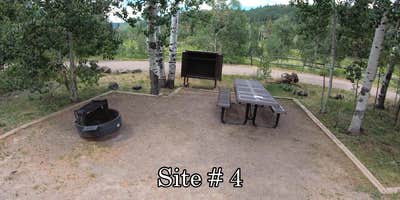
Marvine Campground has five horse campsites. The only corrals available for public use are the ones at the horse camp sites in the campground. The corrals at the Marvine Trailhead are for Outfitter and Guide use only. Additional facilities at the campground include tables, fire grates, vault toilets and hand pump drinking water. Trash service is provided. Electrical hook-ups are not available. Livestock may be watered in the stream, about 200 yards from the campground.
Natural Features
In the heart of the Rocky Mountains, the 2.3 million acre White River National Forest is a place of serenity and adventure, boasting 8 wilderness areas, 4 defined seasons, and 10 peaks surpassing 14,000 feet in elevation. Wildlife in the area abounds. Bighorn sheep navigate rocky ridges, moose graze along the streams and bull elk bugle at dusk. Scenic rivers sustain populations of cutthroat, rainbow, and brown trout. Alpine regions provide habitat for pika and ptarmigan. These species, along with many others, depend on surrounding undeveloped wilderness, clean streams, and diverse forests to live.
Contact Info
For facility specific information, please call (801) 226-3564.
Nearby Attractions
East Marvine Trail #1822: The trail leads up East Marvine Creek, through the Flat Tops Wilderness to Johnson Lake. At the summit Big Marvine Peak offers a panoramic view of the Flat Tops Wilderness and the surrounding area.Marvine Trail #1823: The Marvine Trail begins at the end of County Road 12 right outside the campground. It accesses Marvine Creek and Marvine Lakes providing a great opportunity to fish.Marvine Lake and Slide Lake: These two lakes cover 135 surface acres and offer rainbow, brook, and cutthroat trout fishing.West Marvine Trail #1868Papoose Creek Trail #2248: leads up Papoose Creek past several short waterfalls, to Papoose Basin. It then climbs onto the Flat Tops Plateau where it intersects the Oyster Lake Trail 1825.Ute Creek Trail #1824
Charges & Cancellations
Once your reservation start date has begun, neither the Recreation.gov Contact Center nor the campground manager will be able to modify your reservation.
Warning 2 Alerts are In Effect
There are 2 alerts for this campground. Camp safely!
Warning 2 Alerts are In Effect
There are 2 alerts for this campground. Camp safely!
Our facility is experiencing a temporary water outage. Please bring all the water youll need for your visit, including drinking water.
Air Quality at this campground may currently be unhealthy for sensitive groups.
RV Road Trip Guides


Map & DirectionsMarvine Campground is located in Colorado near Meeker
Directions
The Marvine Campground is located 35 miles east of Meeker. From Meeker, take Colorado Highway 13 east for 1 mile, then turn east on Rio Blanco County Road 8 and follow this for 28 miles. Turn south (right) at Fritzlans' Guest Ranch, cross the bridge and turn east (left) on Rio Blanco County Road 12. Follow this 6 miles to the Marvine Campground. Elevation: 8,200 Ft Address: 32201 County Rd 8, Meeker, Colorado 81641
Coordinates
40.0069444 N
107.4261111 W
Connectivity
 T-MobileNo Coverage
- VerizonNo Coverage
- AT&TNo Coverage
Connectivity
- T-MobileNo Coverage
- VerizonNo Coverage
- AT&TNo Coverage
Access
- Drive-InPark next to your site
- Walk-InPark in a lot, walk to your site.
Site Types
- Tent Sites
- RV Sites
- Standard (Tent/RV)
- Equestrian
Features
For Campers
- Trash
- Firewood Available
- Reservable
- Drinking Water
- Toilets
- Pets
- Fires
For Vehicles
- Water Hookups
- Pull-Through Sites
- Big Rig Friendly
Contact
General Info
Reservations
Drive Time
- 2 hrs 26 min from Grand Junction, CO
- 4 hrs 24 min from Denver, CO
- 4 hrs 33 min from Boulder, CO
- 5 hrs 4 min from Fort Collins, CO


