Dispersed Camping near Mabelvale, AR

26 campgrounds · Check availability for any dates.

Search destinations
    Add dates

    Dispersed camping opportunities near Mabelvale, Arkansas are concentrated in the Ouachita National Forest, approximately 30-45 minutes west of the area. Camp Robinson Dispersed Site offers free primitive camping with minimal facilities, while Harris Brake Lake provides lakeside camping with picnic tables. Forest Road 179 Creekside Dispersed and several sites along Forest Road 132 feature typical dispersed camping conditions with rock fire rings and level parking areas.

    Most dispersed sites in the region require self-sufficiency. No drinking water, toilets, or trash service is available at these locations. According to reviews, the Forest Road 132 sites are "mostly level" with "rock fire rings" and can typically accommodate "2 vehicles." Campers should pack out all waste and bring sufficient water. Cell service varies significantly by location and carrier, with T-Mobile coverage reported as spotty throughout the area.

    Road conditions to these sites vary seasonally. Forest Roads 132 and 179 are generally passable for standard vehicles when dry, though several campers note "minor erosion" and "bumpy/rocky" sections that may challenge low-clearance vehicles. Brown Creek Road (FR805) has been reported to have "moderately rough" spots after spring storms, though "2WD passenger cars can make it if driven carefully." During wet weather, high-clearance vehicles are recommended for accessing most sites. Fires are permitted at established fire rings, but seasonal restrictions may apply during drought conditions. The Ouachita National Recreation Trail provides hiking opportunities near several of these dispersed sites, with multiple access points along Forest Road 132.

    Hot Springs National Park Camping Guide - The Complete Guide

    Get the guide now

    View Guide

    Best Dispersed Campgrounds near Mabelvale (26)

      1. Harris Brake Lake

      4.1(15)31mi from Mabelvale

      "The place was mowed, there was a picnic table and firepit and the previous occupant left us some gathered firewood. This is small as far as public land goes; more like a little park."

      "No amenities but it’s quiet and pretty and free. The sunset was gorgeous. A little bit of a drive off of I40 but it’s a fantastic spot. We are the only ones here"

      2. Camp Robinson Dispersed Site

      3.8(4)24mi from MabelvaleTents

      "I definitely put on bug spray right away. Nice place to sleep and get back on 40East in the morning. Doing a cross country from San Francisco to Pennsylvania."

      "Great spot to pitch a tent by lake Conway. Isolated but not too far out."

      3. Goats Beard Bluff Dispersed Campsite

      1.0(1)16mi from Mabelvale

      4. Forest Rd 179 Creekside Dispersed

      3.0(1)27mi from MabelvaleRVs, Tents

      5. Ouachitas FR179 Dispersed Site

      3.0(1)27mi from MabelvaleRVs, Tents

      6. Forest Rd 179 Dispersed

      3.0(1)28mi from MabelvaleRVs, Tents

      7. Brown Creek Cascade Dispersed Campsite

      4.5(2)32mi from MabelvaleTents

      "Popular dispersed campsite in the Ouachita National Forest. Only one site; not a campground. Located on the gravel Brown Creek Road in Perry County, Arkansas."

      "Didn’t have to drive too far down the road found a spot on the left. Nice stone camp fire circle, good flat spot for my tent, which is a four person."

      8. FR132/152 T-Junction Dispersed, Ouachita NF, AR

      3.0(1)29mi from MabelvaleRVs, Tents

      9. Base of North Fork Pinnacle Dispersed, Forest Road 132

      4.0(1)30mi from Mabelvale

      "Large dispersed campsite in a wooded area positioned between the Winona Scenic Drive (Forest Road 132) and the Ouachita National Recreation Trail in the Ouachita National Forest, Arkansas."

      10. Forest Service RD 132 Ouachita National Forest

      4.6(5)38mi from MabelvaleRVs, Tents

      "The dirt road starting at HWY-7 is virtually impassible to get to this campground. I ended up stopping one mile in because I simply could not continue and camped off the dirt road."

      "Large site if you are sleeping on the ground bring plenty of padding it is rocky and no very flat. If you are in a rooftop there are plenty of rocks to level up on. Great views"

    2026 Explorer Giveaway

    Review Campgrounds. Win Prizes.

    Enter to Win

    Drive Time


    Dispersed Camping Reviews near Mabelvale, AR

    48 Reviews of 26 Mabelvale Campgrounds


    • Fred S.The Dyrt PRO User
      Feb. 12, 2022

      Dispersed FR132 Ouachita National Forest, AR

      Dispersed Camping near Ouachita National Recreation Trail, AR

      Located along Forest Road 132 (Winona Scenic Drive) in the Ouachita National Forest, Saline County, Arkansas. Flatside Wilderness Area located across the road from the site. Access to the Ouachita National Recreation Trail located nearby. Free dispersed site, no facilities. Rock fire ring. Should be enough parking for 2 vehicles. Suitable for tent camping, car camping, truck camping & van camping. Mostly level. There was plenty of firewood left by the fire ring. Camped here in February; very quiet. Only 2 vehicles drove by. Had a few bars of T-Mobile service.

    • Fred S.The Dyrt PRO User
      Jan. 14, 2022

      Brown Creek Cascade Dispersed Campsite

      Free dispersed camping in the Ouachita National Forest

      Popular dispersed campsite in the Ouachita National Forest. Only one site; not a campground. Located on the gravel Brown Creek Road in Perry County, Arkansas. The South Fork of Brown Creek runs behind this campsite. Located next to the trailhead for Brown Creek Cascade - a short 1/4 mile hike (includes a creek crossing). This campsite is suitable for tent camping, car camping, camper vans & truck campers. Two vehicles can easily fit on this level site. There are other dispersed sites along Brown Creek Road. The site is close to the road; there's a large mud puddle covering one of the 2 entrances to this site. 2-wheel drive passenger cars can make it to the site. Large pine trees on the site. Hammock camping is possible. No water (except for creek). No toilets nor showers. No trash - take out what you bring in. May need to hike a ways in the woods to find firewood. Large rock fire ring on site. No AT&T and T-Mobile cell service. Very quiet; no vehicles passed by during the night. The sound from the creek was soothing.

    • Fred S.The Dyrt PRO User
      Apr. 23, 2025

      Brown Creek Rd/FR805 Dispersed

      Nice wooded dispersed site above a small creek

      Coordinates: 34.87057,-92.89844. Camped here on April 20, 2025. Located along Brown Creek Road (Forest Road 805), appoximately 1/2 mile west of the Brown Creek Cascade dispersed site and trail head (see separate listing). Large, level site with a dirt surface. Should easily accomadate 2 or 3 rigs and tents. Recommend campervan and smaller rigs. Due to the trees on the site, a truck camper will have a difficult time pulling all the way into the site (although it can park on the access driveway). Easy access from the forest road. The site is clearly visable from the forest road; no privacy, and dust may be an issue during the dry season. Only 6 vehicles passed by during my stay (which was on a Monday evening). There is a large, nicely constructed rock fire ring on the site; other than this, there are no amenities at the site. A small creek is down the hill behind the site; the creek is dry during the dry season. A beautiful wall of trees is across the creek. The site is shaded; solar charging and Starlink connectivity may be difficult. Hammock camping is possible. No T-Mobile cell service. No access to hiking trails at the site; trailheads for Brown Creek Cascade and the Ouachita National Recreation Trail are a short drive away. Loved this site. Peaceful at night. The only sounds came from the birds, the breeze and the creek. Note that due to recent severe Spring storms, portions of Brown Creek Road have some erosion. The rocky surface is moderately rough in places, although a 2WD passenger car can make it if driven carefully through the rough spots. No issues for high clearance 4x4 vehicles.

    • Fred S.The Dyrt PRO User
      May. 18, 2024

      Ouachitas FR179 Dispersed Site

      Creekside dispersed camping in the Ouachita National Forest

      Camped here on Dec 13, 2023. Along well maintained gravel forest road, FR 179 in the Ouachita National Forest, Saline County, Arkansas. Really nice large site with a creek that flows into the North Fork of the Saline River was behind the site. Site appears to be large enough for 2 rigs no large than a truck camper. Multiple tents can be set up here. Did not have a problem parking our camper van on a level spot. The dirt surface is level. The site has a rock fire ring. Only a few vehicles drove by the site on FR179. Lots of trees surrounding the site with an open sky above for star gazing. Fishing is possible in the North Fork of the Saline River a short walk south of the site. No hiking trails nearby. No T-Mobile or AT&T cell service.  Love this spot!

    • Samuel S.
      Nov. 13, 2021

      Harris Brake Lake

      Maintained, lovely view, FREE

      We had a really great night here. The place was mowed, there was a picnic table and firepit and the previous occupant left us some gathered firewood. This is small as far as public land goes; more like a little park. Very pretty however, and lovely view of the lake!

      I am towing a 19' travel trailer. And someone else is here with a 22'. There are a few places to park with no need to backup.

      My coordinates: 34.9831627, -92.7626397

    • Fred S.The Dyrt PRO User
      Jun. 21, 2024

      FR132 Grindstone Mountain Area Dispersed, Ouachita NF. AR

      Forested Group Dispersed Site near Crystal Mountain Overlook

      Coordinates: 34.83903, -92.94556.  Set back from Forest Road 132 off of an old track - a short distance west of Forest Road 75. There is some minor erosion on the access to this site from FR132. Large site; good for groups. Should accommodate 4 rigs -  truck campersize & smaller. This site can accommodate 4x4 drivers that are planning to tackle Forest Road 132A to the Crystal Mountain Overlook - a short distance east of this site. FR132A is hikeable for those who do not drive high clearance 4x4s. The dispersed site has a level dirt surface. There are two rock fire rings. Beautiful forest backdrop. No T-Mobile service.

    • Fred S.The Dyrt PRO User
      Jan. 9, 2025

      Forest Rd 179 Creekside Dispersed

      Large creekside dispersed site

      Coordinates: 34.82029,-92.82184. Large creekside dispersed campsite located on a rocky, bumpy track, about 150 yards east of Forest Road 179 (aka Wildcat Mountain Rd). If going southbound on FR179, the track is on the left immediately after crossing a bridge. The track may look sketchy to some drivers, but I drove down it okay in my Subara. Good spot for car camping. The site itself is very rocky, so it may be uncomfortable for tent camping. There are trees for hammock camping. There are 3 large rock fire rings. This site is prone to flooding. The site appears to be popular and well used. There are no hiking trails, but the access track passes the site and continues along the creek - good for an easy stroll. Tried fishing here, but no luck. I do know from previous experience that there is fish in the creek. The creek is nice for a summertime dip when its running high. The site is mostly shaded; may be difficult to get a Starlink connection. I received no cell service. This is a pretty nice site, offering some privacy from the forest road and a wonderful sound of the creek.

    • Fred S.The Dyrt PRO User
      Jun. 21, 2024

      Crystal Mountain Dispersed

      Good View with Difficult Access

      I haven't camped here recently. Forest Road 132A, which climbs up to the Crystal Mountain Overlook fom Forest Road 132, is not maintained and badly eroded. Drivers with high clearance 4x4 vehicles and OHVs will enjoy driving up this track, but I don't recommend this drive for the average passenger vehicle. I no longer attempt this with my stock AWD Subaru Outback - just not enough clearance. There are two rock fire rings at the top. Despite the nice views at the top, the dispersed campsites are usually trashy. I included an older photo of the view with Lake Winona in the distance.


    Guide to Mabelvale

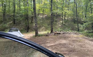
    Dispersed camping near Mabelvale, Arkansas concentrates primarily within the Ouachita National Forest's eastern region where elevations range from 400-800 feet. Summer temperatures often exceed 90°F with high humidity, while spring camping typically experiences 70-80°F daytime temperatures with frequent thunderstorms. Most camping areas feature mixed pine-hardwood forests with rocky, uneven terrain that requires careful site selection.

    What to do

    Hiking the North Fork Pinnacle trail: From Base of North Fork Pinnacle Dispersed, visitors can access the Ouachita National Recreation Trail for day hikes. "The North Fork Pinnacle viewpoint is a half-mile hike from the campsite" with "easy access from both the forest road and the backpacking trail," making it convenient for both hikers and softroaders.

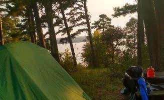
    Waterfront activities: Harris Brake Lake offers fishing and swimming opportunities. "There is a decent looking boat launch on the property," according to one camper, while another noted that "the locals fish and swim in the lake so light traffic" can be expected. The lake is accessible for various watercraft, though water levels may vary seasonally.

    Wildlife watching: Evening hours at several dispersed sites provide excellent wildlife viewing opportunities. One camper at Harris Brake Lake reported, "the fireflies here are amazing!" while others have mentioned seeing gray foxes and various bird species. Morning hours typically offer the best bird watching, particularly in areas near water sources.

    What campers like

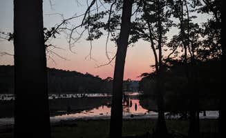
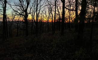
    Sunset viewing spots: Forest Service RD 132 offers exceptional sunset vistas. Campers describe "fantastic unobstructed view of the hills to the south" and one reviewer specifically mentioned it's a "great spot; fantastic view during the winter season." Several sites along this road face west for optimal sunset viewing.

    Privacy and isolation: Camp Robinson Dispersed Site provides relatively secluded camping experiences. One camper noted it's an "isolated but not too far out" spot to pitch a tent by Lake Conway. Another mentioned, "peaceful and quiet. The birds and frogs sang all evening."

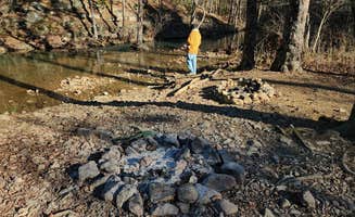
    Natural water features: Creekside camping provides natural soundscapes and cooling effects. At Forest Rd 179 Creekside Dispersed, one camper described "a wonderful sound of the creek" behind their site. The location offers "a large creekside dispersed campsite" approximately 150 yards east of the main forest road, adding distance from traffic noise.

    What you should know

    Road conditions and access challenges: Forest roads in the area deteriorate after rain events. As one camper at Brown Creek Cascade Dispersed Campsite noted, "there's a large mud puddle covering one of the 2 entrances to this site." While "2-wheel drive passenger cars can make it to the site," conditions vary seasonally.

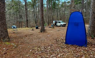
    Site surfaces and tent placement: Many sites have rocky, uneven ground that impacts tent comfort. One camper mentioned finding "a good flat spot for my tent," but others caution about "a dirt surface with some embedded rocks jutting up" and sites that are "not very flat" requiring "plenty of padding" for ground sleeping.

    Local wildlife encounters: Ticks and insects can be problematic, especially in warmer months. A camper at Harris Brake Lake reported, "there is a lot of ticks here i pulled 7 off of me and my dog in one night." Bug spray is essential from spring through fall, particularly in sites near water.

    Tips for camping with families

    Best family-friendly sites: Choose locations with level parking and clear boundaries. "Large site with one rock fire ring. Can fit a couple of vehicles," describes one camper about Forest Service RD 132, making it suitable for families needing multiple tents or space for activities.

    Kid-friendly activities: Several sites offer accessible creek exploration. At Forest Rd 179 Ouachita NF, "a creek that flows into the North Fork of the Saline River was behind the site," providing natural water play opportunities. Sites with creeks typically offer shallow areas for supervised water activities.

    Safety considerations: Some sites experience unexpected nighttime traffic. A Camp Robinson visitor warned, "people kept driving in" throughout the night, with one incident at 1:30 am when "a loud truck came in slinging rocks and a guy was screaming out the window." Consider sites further from main roads for more predictable overnight experiences.

    Tips from RVers

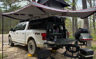
    Leveling challenges: Bring leveling blocks for uneven surfaces. A camper noted "maneuvering my van into position took some effort due to the trees at this spot; a little bit of leveling was required," while another mentioned using "plenty of rocks to level up on" for rooftop tents.

    Size limitations: Most sites accommodate smaller rigs only. One camper specified a site "can comfortably accommodate 2, maybe 3 rigs - truck camper & smaller," while another confirmed they "didn't need to do any backing up to get in or out" with a "25' travel trailer." Larger RVs should research specific sites carefully before attempting access.

    Frequently Asked Questions

    Which is the most popular dispersed campsite near Mabelvale, AR?

    According to TheDyrt.com, the most popular dispersed campground near Mabelvale, AR is Harris Brake Lake with a 4.1-star rating from 15 reviews.

    What is the best site to find dispersed camping near Mabelvale, AR?

    TheDyrt.com has all 26 dispersed camping locations near Mabelvale, AR, with real photos and reviews from campers.