Public Campground
Upper Arcadia
Upper Arcadia is located near Safford, AZ, within the Coronado National Forest. The terrain consists of forested areas and rugged landscapes. Temperatures can range from 30°F in winter to 90°F in summer. Nearby attractions include the Mount Graham International Observatory and Roper Lake State Park.
Description
Overview
Upper Arcadia sits along Swift Trail in southeastern Arizona, providing an escape from desert heat and a pleasant place to take in the high desert scenery in spring and fall. Visitors enjoy hiking, camping, birding and picnicking.
Recreation
The campground lies along the Swift Trail Scenic Drive, which takes visitors from the Sonoran Desert at 2,900 feet to alpine meadows and forest on the 9,000+ foot ridges of the Pinale__o Range. Because of its diverse habitat, the area is well-known for birding and wildlife watching. The Swift Trail provides access to a number of hiking, horseback riding and mountain biking trails, along with several other campgrounds that invite you for an afternoon picnic. A trip up to Riggs Lake, stocked with trout by Arizona Game & Fish, or to the Columbine Visitors Center could make a worth-while day trip as well. The Arcadia Trail #328 starts at the Upper Arcadia Campground and leads up the mountain to Shannon Campground. A 1-mile spur off this trail leads to the top of Heliograph Peak, one of the highest mountains in southeastern Arizona.
Facilities
The group camping area can accommodate up to 75 people. Amenities include drinking water (available seasonally), vault toilets, picnic tables, and campfire rings with grills. Bear-proof food lockers and trash cans are provided to keep visitors and wildlife safe. Dead-and-down firewood may be collected in and around the campsite. Several first-come, first-served sites are located nearby (must pay separately).
Natural Features
The shady campground is in a thick forest of tall ponderosa pines interspersed with Gambel oaks and Arizona walnuts, at an elevation of 6,700 feet. The Coronado National Forest covers 1.78 million acres of southeastern Arizona and southwestern New Mexico. Elevations range from 3,000 to 10,720 feet in 12 widely scattered mountain ranges, or "sky islands," that rise dramatically from the desert floor, supporting biologically diverse plant communities.
Nearby Attractions
The Mount Graham Wilderness Study Area, which includes the 10,720-foot Mount Graham, the tallest mountain in southern Arizona. Columbine Visitor Center, Riggs Lake, and a variety of trails can be accessed along the Swift Trail Scenic Drive. The town of Safford is approximately a 30 minute drive from the Upper Arcadia campground, heading north on SR 191. Safford is home to our Ranger Station, where you can go to find information about trails, camping, hunting and fishing, and other questions you may have about our district (open Monday-Friday, 8am-4:30pm).
Charges & Cancellations
Please review the Rules & Reservations Policies page on recreation.gov
Fee Info
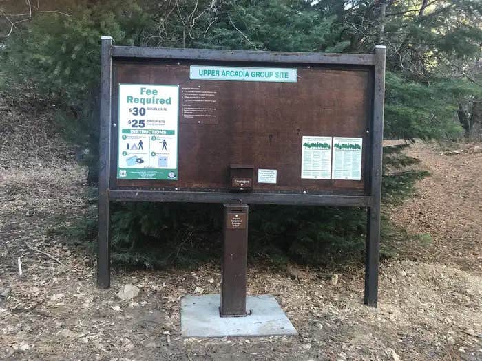
This site has a $25 per night fee and a $5 per vehicle per night fee. Your check-out through recreation.gov will only include the Nightly/Daily rate. You must pay the per vehicle fee by cash or check upon arrival at the designated Fee Station.
Location
Upper Arcadia is located in Arizona
Directions
From Safford, Arizona: Take State Route 191 south for 6 miles. Turn right onto State Route 366/Swift Trail and travel 11.5 miles to the Arcadia Campground entrance (MM 125.5), taking the next right turn to access Upper Arcadia. From Tucson, Arizona: Take I-10 East for 90 miles. Take exit 352 for State Route 191, and turn left toward Safford. Drive 26.3 miles north and turn left on State Route 366/Swift Trail. Continue for 11.5 miles to the Arcadia Campground entrance (MM 125.5), taking the next right turn to access Upper Arcadia.
Address
711 14th Avenue, Suite D
Safford, AZ 85546
Coordinates
32.6494444 N
109.8186111 W
Connectivity
- T-Mobile5GExcellent Coverage
- VerizonLTESome CoverageVerified by 2 usersLast on 1/17/26
- AT&TLTESome CoverageVerified by 2 usersLast on 1/17/26
Connectivity
- T-Mobile5GExcellent Coverage
- VerizonLTESome CoverageVerified by 2 usersLast on 1/17/26
- AT&TLTESome CoverageVerified by 2 usersLast on 1/17/26
Access
- Drive-InPark next to your site
- Hike-InBackcountry sites.
Site Types
- Tent Sites
- RV Sites
- Standard (Tent/RV)
- Group
Features
For Campers
- Picnic Table
- Reservable
- Drinking Water
- Toilets
- Pets
- Fires
Drive Time
- 1 hr 55 min from Sierra Vista, AZ
- 1 hr 57 min from Tucson, AZ
- 3 hrs 11 min from Las Cruces, NM
- 3 hrs 26 min from Phoenix, AZ


