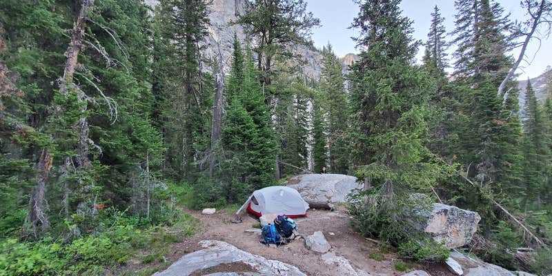
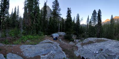
Death Canyon Camping Zone in Grand Teton National Park is surrounded by rugged mountain terrain and dense forests. Temperatures range from 30°F to 70°F, depending on the season. Nearby attractions include the scenic Phelps Lake and the challenging Death Canyon Trail, offering opportunities for hiking and wildlife observation.
Description
Head into Death Canyon for spectacular views of Phelps Lake and the surrounding peaks. Starting from the Death Canyon Trailhead, hikers will climb to the Phelps Lake Overlook before dropping down to Phelps Lake then climb back up into Death Canyon. The trail winds through forests and up rocky slopes before reaching the patrol cabin in Death Canyon.
Several moderate-very strenuous trails leave from the Death Canyon Trailhead. To access trails, drive down the Moose-Wilson road and follow signs to the Death Canyon Trailhead. The Moose-Wilson Road is closed to RVs and trailers and occasionally has closures. The Death Canyon Trailhead is located one mile down a rutted, dirt road. The road is not recommended for vehicles with low clearance. Exercise caution when driving down the Death Canyon Road and pull fully off of the road if parking on the shoulder.
Multiple hikes from Death Canyon include access to backcountry campsites. A backcountry permit is required for all overnight stays in the backcountry.
Always be prepapred when hiking in Grand Teton. Carry water for every member of your group, be alert to your surroundings, and understand your limitations on distance and elevation gain. Several trails from the Death Canyon Trailhead can hold snow until mid-July. Hikers should use caution when traveling over snow and not attempt trails unless they have previous snow experience and the proper equipment.
Fee Info
$45 for advanced reservations, booked through Recreation.gov $35 for walk-in permits
Reservation Info
All reservations are processed through Recreation.gov in real-time. To facilitate your reservation experience, please establish an account on Recreation.gov prior to the advance reservation season.
A non-refundable service fee of $45 will be charged for each reservation (fee is per trip, not per person). One-third of the sites are reserved in advance, leaving two-thirds available for walk-in permits. Walk-in permits will be assessed a $35 fee per trip.
Some camping zones fill quickly. Download the backcountry trip planner to review regulations and a map showing the authorized camping zones. Individual party reservations can consist of up to six people. Groups of 7-12 people must camp in designated group sites indicated on the brochure map. View maps of the backcountry camping zones.
RV Road Trip Guides

Map & DirectionsDeath Canyon Camping Zone is located in Wyoming near Teton Village
Directions
Park at the Death Canyon Trailhead for access to the Death Canyon - Static Peak Divide Junction Trail. The Death Canyon Trailhead is located one mile down a rutted, dirt road. The road is not recommended for vehicles with low clearance. Exercise caution when driving down the Death Canyon Road and pull fully off of the road if parking on the shoulder. The Death Canyon to Static Peak Divide Junction Trail is a strenuous long hike, 7.9 miles (12.7 km) roundtrip out and back trail with over 2,100 ft of elevation gain. The trail has numerous rocks and small boulders in the pathway.
Coordinates
43.66671887 N
110.836931 W
Connectivity
 T-MobileNo Coverage
- VerizonNo Coverage
- AT&TNo Coverage
Connectivity
- T-MobileNo Coverage
- VerizonNo Coverage
- AT&TNo Coverage
Access
- Walk-InPark in a lot, walk to your site.
- Hike-InBackcountry sites.
- Boat-InSites accessible by watercraft.
Site Types
- Tent Sites
- Group
- Tent Cabin
- Equestrian
Features
For Campers
- Picnic Table
- Reservable
- Toilets
- Fires
Drive Time
- 2 hrs 10 min from Idaho Falls, ID
- 2 hrs 53 min from Pocatello, ID
- 4 hrs 25 min from Bozeman, MT
- 4 hrs 32 min from Logan, UT


