

j
jeremy M. Traveler
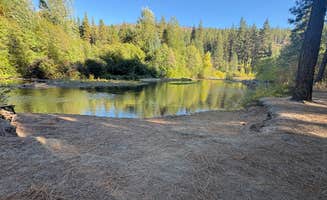
Sullivan Pond Camp
Winthrop
The campsite is right by the forest road. Fire restrictions are in place for the summer months, so no campfires. Quite a few mosquitos do bring spray or other repellant types.
11 campgrounds · Check availability for any dates.
Dispersed camping near Tonasket, Washington primarily occurs on public lands managed by the Bureau of Land Management and U.S. Forest Service. Several primitive dispersed campsites are available around lakes and ponds in the region, including Forde Lake, Blue Lake North, Chopaka Lake, and Sidley Lake. Most sites require a Washington Discover Pass or other permits for legal camping. Sullivan Pond Camp and Upper Bobcat offer additional dispersed options for those seeking more remote experiences. These areas typically provide minimal or no amenities, maintaining their primitive character.
Access to many dispersed sites requires travel on unpaved roads with varying conditions. Several locations, such as Sullivan Pond Camp, may need high-clearance vehicles or 4WD, particularly after rain or during spring thaw. Most areas have seasonal availability, with Chopaka Lake open from April 15 to November 15, and others like Forde Lake and Blue Lake North accessible from early May through late October. Fire restrictions are common during summer months, with several sites prohibiting campfires entirely. Toilet facilities exist at some locations, but drinking water is rarely available, requiring campers to pack in their own supplies.
The dispersed camping areas around Tonasket provide opportunities for solitude and wildlife viewing. Sites near water bodies offer fishing possibilities, while the surrounding terrain supports hiking and exploration. Campers should be prepared for insects, particularly mosquitoes near lakes and ponds. A review noted that Sullivan Pond Camp is "nice, quiet dispersed camping next to Sullivan Pond near Winthrop Washington," while another mentioned that Sidley Lake features "Loons and Coyotes are great music." The region experiences low traffic even during peak seasons, though weekend visitation increases during summer months. Visitors should practice Leave No Trace principles, as one reviewer emphasized the importance to "pack everything in and pack out everything too."
"Beautiful Lakes (Sidley & Molson) near historical Old Molson! Definitely dispersed camping in roadside pullouts with outhouse supplied by Fish & Game."
"Nice, quiet dispersed camping next to Sullivan Pond near Winthrop Washington. Recommend 4wd with good clearance. Washington Discover Pass required."
"There is about a dozen pull off spots on the side of the road and then a few more at the top by the lake. The lake was almost non-existent/dried out when we visited."
"It’s on a high flat above a river, which would be easy to walk down to if you wanted to fish plenty of space for cars that are blocked off by larger rock so you could set up a tent if you wanted to or"
"Super close to the river. There were a lot of people, mainly families, but everyone was super respectful and it honestly made me feel safer and a solo traveler. Would definitely go back."
"This is a great location that is pretty much set up for hunting if you’re into that. It’s right on the water and there are plenty of spots and each spot has access areas to the river."
"Just a parking lot a little off the highway. People are rolling in untill about 10:30 and start leaving at 6. Clean pit toilet. Nothing wrong with it, great place just to sleep and keep moving."
"This is a very short drive on a gravel road less than 1/4 mile off paved road. Very large parking lot mostly flat with a few other campsites with fire ring just before it. We took one of those."
The campsite is right by the forest road. Fire restrictions are in place for the summer months, so no campfires. Quite a few mosquitos do bring spray or other repellant types.
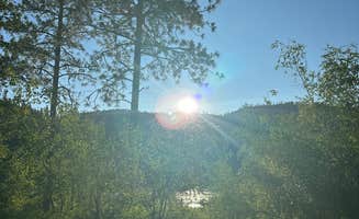
This is a dry Camp only. , no water/power ect. Has a small lake or a large pond? With a beautiful view of the valley floor.
Nice, quiet dispersed camping next to Sullivan Pond near Winthrop Washington. Recommend 4wd with good clearance. Washington Discover Pass required.
My boyfriend and I stayed here before spending time in the Cascades. There is about a dozen pull off spots on the side of the road and then a few more at the top by the lake. The lake was almost non-existent/dried out when we visited. We only saw two other people while there. The views are incredible
This is a great location that is pretty much set up for hunting if you’re into that. It’s right on the water and there are plenty of spots and each spot has access areas to the river. The one in the very back left has its own personal beach area, which is the one that we stayed at. Plenty of spots to choose from and it looks like a paid campground, but it’s free dispersed camping. Fire rings are set up all throughout. We came in September so it was pretty empty when we got here BUT the couple that was here when we got here says that it’s about to get filled up for hunting.
Loons and Coyotes are great music. Beautiful Lakes (Sidley & Molson) near historical Old Molson! Definitely dispersed camping in roadside pullouts with outhouse supplied by Fish & Game. Traffic is very low even though they were trucking out hay while we were there. Fishing slow in August but nice size and were told the town has an ice fishing tournament every winter. We met some great locals and were told of some of the horrible things some dispersed campers have done, come on folks....pack everything in and pack out everything too!! Verizon cell reception was present but the Canadian cell towers are strongest so beware.
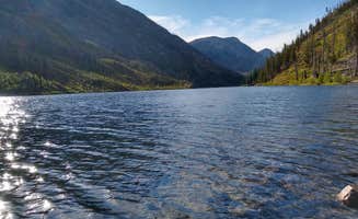
Beautiful lake, long, big and I hear they have fish (not a fisherman). Has several points of access to the lake.
This is a really nice spot and accommodates larger rigs. It’s on a high flat above a river, which would be easy to walk down to if you wanted to fish plenty of space for cars that are blocked off by larger rock so you could set up a tent if you wanted to or just camp in your RV. Beautiful view of the river.
Perfect dispersed area for open camping with plenty of room for tents or campers.
Dispersed camping in the Okanogan Highlands near Tonasket, Washington offers primitive sites on public lands managed by federal agencies. The area sits at elevations ranging from 1,200 to 4,000 feet with a semi-arid climate that creates distinct camping seasons. Road conditions deteriorate significantly after rainfall, particularly on forest service roads accessing more remote sites.
Fishing opportunities: Blue Lake North provides good fishing access with "several points of access to the lake" according to Mike D., who notes it's a "beautiful lake, long, big and I hear they have fish." The lake remains accessible from early May through late October.
Wildlife observation: Sidley Lake offers excellent wildlife viewing opportunities throughout the day and night. Teresa H. shares that "Loons and Coyotes are great music. Beautiful Lakes (Sidley & Molson) near historical Old Molson!" This lake also provides winter recreation as "the town has an ice fishing tournament every winter."
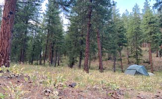
Hiking trails: Black Lake Backcountry Campsite requires hiking to access but rewards visitors with "awesome lake access" according to Jeff C., who described it as "a wonderful site" for backpacking. The trailhead may require a high-clearance vehicle during spring thaw conditions.
Peace and quiet: Sullivan Pond Camp receives consistent praise for its tranquility. Emma T. describes it as a "really peaceful and lovely campsite. Lots of flowers, just a few camping spaces available." This smaller dispersed area provides a sense of seclusion compared to more developed campgrounds.
Solitude during weekdays: Free camping near Tonasket, Washington tends to be less crowded on weekdays, even during summer. At Upper Bobcat Dispersed Camping, Emma observed "Lots of room at your site and between neighbors. Super close to the river." She noted a family-friendly atmosphere that "made me feel safer as a solo traveler."
Proximity to attractions: Goat Creek Sno-Park serves as a practical base camp for exploring the region. Ashley A. calls it a "great place just to sleep and keep moving," and Anna P. notes it's "close to the national park" with "a hitching post and a trail that leaves from the campground."
Permit requirements: Washington Discover Pass is required for most dispersed camping near Tonasket. John T. specifically mentions this requirement for Sullivan Pond Camp, and Emma T. confirms "Washington Discovery Pass is required for camping here."
Access challenges: High-clearance vehicles are recommended for many sites. John T. advises visitors to Sullivan Pond Camp to have "4wd with good clearance" to navigate the forest roads safely.
Insect preparation: Mosquitoes are prevalent at many waterside locations. At Upper Bobcat, PJ H. reported that "bugs were BAD, like hiding in the car and tent bad. Left with more bug bites than I could count." Jeremy M. similarly warns about Sullivan Pond: "Quite a few mosquitos do bring spray or other repellant types."
Limited facilities: Most no-cost camping around Tonasket provides minimal amenities. Forde Lake is described by Mike D. as "a dry Camp only, no water/power ect." Al M. adds that "mosquitoes are present" and notes the "gravel road is fairly busy with plenty of dust boiling up."
Site selection: At Forde Lake, Al M. suggests: "I recommend not taking the first site in even though it looks like it would accommodate a 40 ft rig. Four of the sites looked able to handle our 27 ft trailer. A few are slide in camper sized."
Safety considerations: Upper Bobcat offers good options for families with children as it tends to attract similar groups. Emma noted that "There were a lot of people, mainly families, but everyone was super respectful."
Nearby attractions: Consider visiting historical sites in the area. Near Sidley Lake, Teresa H. mentions the "historical Old Molson" which provides an educational opportunity for children when not at camp.
Site dimensions: For RV camping near Tonasket, Washington, Forde Lake has limited large sites. According to Al M., "The campground has 10 sites... Four of the sites looked able to handle our 27 ft trailer," indicating most sites accommodate smaller rigs only.
Overnight parking: Goat Creek Sno-Park functions well for overnight stays. Anna P. describes it as a "Big open lot where you can easily park cars/campers/RVs/etc. Lots of space and room to pitch tents along the edges." Ashley A. adds it's "Nothing special. Just a parking lot a little off the highway. People are rolling in until about 10:30 and start leaving at 6."
Frequently Asked Questions
Where can I find dispersed camping areas near Tonasket, Washington?
The Tonasket area offers several dispersed camping options. Sidley Lake provides beautiful lakeside camping with roadside pullouts and minimal facilities. It's located near historical Old Molson with both Sidley and Molson lakes nearby. Upper Bobcat Dispersed Camping offers multiple sites with ample room between neighbors and excellent river access. For other options, check out areas like Forde Lake near Loomis or BLM lands around Chopaka Lake. Most dispersed sites in the region require a Washington Discover Pass, and some may need high-clearance vehicles for access.
What are the rules and regulations for dispersed camping in Tonasket National Forest?
Dispersed camping in the Tonasket area forests typically requires a Washington Discover Pass, as noted at Sullivan Pond Camp. Fire restrictions are common during summer months, with complete bans often in place. Most areas follow standard dispersed camping protocols: pack out all trash, camp in established sites only, and stay no longer than 14 days in a 30-day period. Some areas like Forde Lake are designated as dry camps with no water or power hookups. Always check current regulations with the local ranger district before your trip, as rules can change seasonally.
Are there any amenities available at dispersed camping sites near Tonasket?
Amenities at dispersed sites near Tonasket are minimal. Goat Creek Sno-Park offers a clean pit toilet and a large parking area suitable for various vehicles. BLM Chopaka Lake provides basic facilities. Most dispersed sites are true dry camps with no water or power hookups. For water access, Black Lake Backcountry Campsite offers excellent lake access, while Blue Lake North has several lake access points. Always bring your own drinking water, toilet supplies, and pack out all waste.
What is the best time of year for dispersed camping in the Tonasket area?
Late spring through early fall offers the best conditions for dispersed camping around Tonasket, with peak season being June through September. Summer brings warm temperatures but be prepared for fire restrictions and mosquitos, particularly at sites like Sullivan Pond. Reviews from camping at Upper Bobcat mention that bugs can be especially bad in summer. August may offer slower fishing at locations like Sidley Lake. Fall provides cooler temperatures and fewer insects. Water levels at lakes like Forde Lake and Blue Lake North are typically best in spring and early summer. Always check road conditions before heading out, as some sites require good clearance vehicles.
Keep Exploring