The Bureau of Land Management operates this compact 16-site campground within forested terrain along the south fork of the Alsea River. Sites range from $15-40 per night during the April through October season, with no hookups available but drinking water and vault toilets provided. The narrow BLM access road requires careful navigation, particularly for larger rigs over 32 feet.
Sites on the north side back directly to the river, while those on the opposite side face a quiet BLM road. Most sites feature log fence enclosures and provide adequate space for large tents, though the overall footprint remains small. Dawn K. notes that "sites are large and spread out, but it is a small campground." Reviews consistently mention that sites 9 and below offer more privacy than the upper loop sites 10 and above.
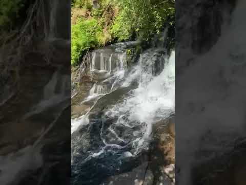
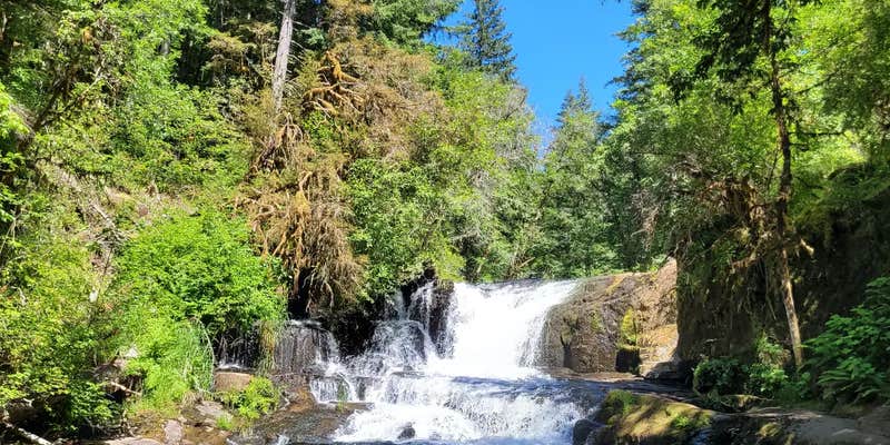
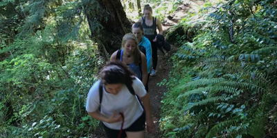
The campground serves as a trailhead for Alsea Falls, though the main access point sits about half a mile up the trail at the day use area. The waterfall hike can extend nearly six miles round trip from the campground itself. James P. describes "lazy shallow rivers and beautiful waterfalls" as highlights for families with children. Mountain bike trails run nearby, and fishing opportunities exist along the river.
Access requires driving narrow mountain roads that can challenge larger vehicles. The sunlight filtering through trees creates visibility issues during certain times of day. Water service occasionally requires maintenance, and vault toilets may need attention during busy periods. Reservations are available and recommended for weekend stays.
For a different river camping experience, Hubert K McBee Memorial Campground provides an alternative just one mile northwest.
Description
Overview
Reserve a site at Alsea Falls on recreation.gov or pay when you arrive for non-reserved campsites using the Recreation.gov Mobile App. You must download before you reach the site since there is no cell reception in the drainage. Alsea Falls Recreation Site is located along a Bureau of Land Management National Back Country Byway, located in the Oregon Coast Range, 13 miles west of Monroe, Oregon, in Benton County. Alsea Falls is open for camping the first weekend in May through the end of September of each year. Day use is open year round. The South Fork of the Alsea River flows through the Alsea Falls Recreation Site, cascading down 30 feet to form Alsea Falls in the day use area.
Recreation
The beautiful surroundings of Alsea Falls can be enjoyed by exploring the trails that wander through the area and lead to the picnic grounds and beyond. On a warm day, Alsea Falls Recreation Site offers cool relief along the river. During the winter months, the South Fork of the Alsea River provides excellent salmon and steelhead fishing. Be sure to check with the Oregon Department of Fish and Wildlife for current fishing regulations.
Facilities
This recreation area has 16 individual campsites; all are reservable. No first come-first served availability, however, you can come by on a nightly basis to camp if the site is not reserved until the reservation holder arrives. Amenities within the campground include drinking water and vault toilets. Several campsites can accommodate large RVs or trailers: up to 32 feet long. A site map is available here.
Natural Features
Forests in all stages of growth line South Fork Alsea National Back Country Byway. The nearby South Fork Alsea River offers painters and photographers endless opportunities to capture the natural beauty of Alsea Falls and the surrounding area. Old growth Douglas fir and western red cedar forests can be seen on the nearby ridges, while younger Douglas fir and vine maples provide a pleasant atmosphere at the Alsea Falls Recreation Site.
Contact Info
This location has limited staffing. Please call (503) 375-5646 for general information.
Nearby Attractions
The Fall Creek Day-Use Trailhead offers over 12 miles of mountain bike specific trails. Hikers can use these trails as well. Green Peak Falls with a drop of 45 feet is accessed by road or trail through the private campground of McBee Park. Follow the markers along the trail and road. Alsea Trout Hatchery is north of the town of Alsea.
Charges & Cancellations
Standard fees apply and are non-refundable. Visit https://www.recreation.gov/rules-reservation-policies for more information.
Fee Info
Northwest Oregon District Recreation Site Business Plan The $15, $20, and $40 campsite fee includes one vehicle per site. Extra camping vehicle fee of $5 each is collected at the site. Additional service fees apply and are non-refundable. Cash or check made out to Bureau of Land Management is accepted. Fee envelope receipt stub must be displayed on the dash.
RV Road Trip Guides


Map & DirectionsAlsea Falls Recreation Site (campground) is located in Oregon near Alsea
Directions
From Corvallis: Take Hwy 99W south about 15 miles. Turn right on Alpine Road, follow for approximately 9 miles. Alpine Road turns into South Fork Road. Follow about 4 miles to the Alsea Falls Campground on the right. From Alsea: Travel south from the town Alsea on Alsea-Deadwood Hwy for about 1 mile. Turn left on the South Fork Road and follow for approximately 8.5 miles (stay on main paved road). Pass the Alsea Falls Day-Use about 0.5 miles and turn left into the Alsea Falls Campground Entrance.
Address
No physical address
S Fork Rd
Alsea, OR 97324
Coordinates
44.3205611 N
123.4878222 W
Connectivity
 T-MobileNo Coverage
- VerizonNo Coverage
- AT&TNo Coverage
Connectivity
- T-MobileNo Coverage
- VerizonNo Coverage
- AT&TNo Coverage
Access
- Drive-InPark next to your site
- Walk-InPark in a lot, walk to your site.
Site Types
- Tent Sites
- RV Sites
- Standard (Tent/RV)
Features
For Campers
- Trash
- Picnic Table
- Firewood Available
- Reservable
- WiFi
- Drinking Water
- Toilets
- Alcohol
- Pets
- Fires
Drive Time
- 38 min from Corvallis, OR
- 40 min from Corvallis, OR
- 45 min from Eugene, OR
- 47 min from Eugene, OR
- 52 min from Albany, OR
- 54 min from Albany, OR
- 1 hr 14 min from Salem, OR
- 1 hr 16 min from Salem, OR