Primitive camping near Dahlonega, Georgia concentrates around the southern edge of the Chattahoochee National Forest, with sites generally found at elevations between 1,800-3,500 feet. The area experiences significant seasonal temperature variations, with summer highs averaging 85°F and winter lows regularly dropping below freezing. Most dispersed camping locations in this region feature established fire rings and minimal ground clearing but require campers to bring all necessary supplies.
What to do
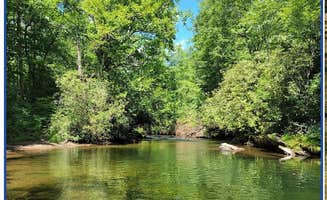
Waterfall swimming spots: Several creek-side camping areas near Dahlonega offer natural swimming opportunities. At Indian Grave Gap Campsite, campers can access "both waterfalls are lovely. One has a nice swimming hole," according to Gillian S. The site is approximately one mile from the High Shoals Trailhead.
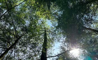
Astrophotography opportunities: The Tray Mountain area provides exceptional night sky viewing due to minimal light pollution. Austin C. notes that Corbin Creek Tray Mountain "sits within the few dark areas within north Georgia" making it "worth it if you're into astrophotography."
Hiking loop trails: Several unofficial trails connect to established routes. At Dicks Creek Falls, one camper found "a trail at this site just on the other side of the water which went a few miles around to the road and looped back," though they caution it "hadn't been maintained in a bit" requiring "a decent amount of climbing and exploration."
Wildlife observation: The forests surrounding Dahlonega support diverse wildlife populations. While camping in the area, visitors frequently encounter deer, turkey, and various bird species. Remember to properly store food as black bears inhabit the region, with one camper noting they were "warned about bears in the area so were very cautious about hanging our bear bag a little extra distance away."
What campers like
Creek-side camping: Access to water remains highly valued at primitive sites. One camper at High Shoals Falls Trail Dispersed appreciated that "the cool waters of High Shoals Creek offer rewarding refreshment after a day of exploring the various wildflowers and plant life while serving as a soothing sound to fall asleep too while stargazing."
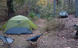
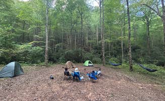
Large group accommodations: Some sites feature expansive clearings suitable for multiple tents. At Indian Grave Gap, Gillian S. reports "three campsites in the immediate area" with "each site is huge" allowing groups to "spread out," though this "meant having to do a lot of walking back and forth for stuff."
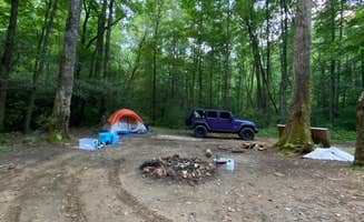
Vehicle-accessible remote camping: Several primitive sites combine backcountry experience with vehicle convenience. At Corbin Creek Tray Mountain, one camper describes it as "Hike in style camp with the convenience of having your vehicle," though noting that "A 4wd with moderate clearance is helpful."
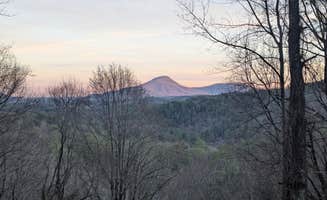
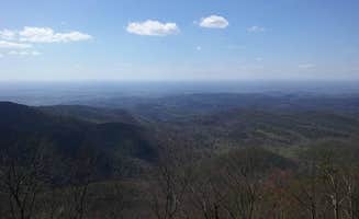
Mountain-top views: Elevated camping locations provide scenic vantage points. At Cowrock Mountain, Clay A. reports "dispersed camp sites at or near the summit of Cowrock Mountain offer wonderfully shaded spots with long range views of the Blue Ridge. Perfect spot for hammocks or tents right off the trail with large rocky outcrops for your views."
What you should know
Vehicle requirements vary significantly: Many forest roads deteriorate seasonally, requiring appropriate transportation. Rebecca M. advises that Corbin Creek Tray Mountain is "more Jeep friendly than full size vehicles, to get a spot down by the creek. But it is possible to get a full size 4*4 truck down the switch back."
Water availability concerns: Most primitive sites lack reliable water sources beyond natural creeks. When camping at Preacher's Rock, Ernesto H. cautions "No hay agua cerca" (there is no water nearby), requiring hikers to carry all water for their stay or filter from streams when available.
Recreational shooting common: Several camping areas experience hunting and target practice. At Corbin Creek Tray Mountain, one camper reported they "did not see any signs of large predators but did see lots of spent 12GA shells and other casings."
Crowding during peak seasons: Popular spots can fill quickly during summer months and holidays. A Dicks Creek Falls camper observed "It was over full last time I was there summer of 2024," while another notes the Jones Creek area "seems to be popular for local dirt bikers."
Tips for camping with families
Beginner-friendly waterfall sites: For families with children, locations with easy water access provide natural entertainment. At Dicks Creek Falls Campsites, "There are a couple closer to water" sites, and "The further up you go, you have many spots to pull off to access the creek and a couple of trails to other set of falls."
Safety considerations: Some primitive sites present challenges for young children. At Preacher's Rock, access requires "unos 40 minutos, al final se vuelve más exigente si lleva mochila grande" (about 40 minutes, becoming more challenging at the end if carrying a large backpack).
Restroom planning: Most dispersed sites lack facilities entirely. A Dicks Creek visitor noted "There is a 3 mile long dirt road to travel on. There is one large set of falls towards beginning of dirtroad with a porta potty at parking area," making this location a practical starting point for families.
Site selection timing: During busy periods, arrive early to secure preferred locations. One Dicks Creek camper advises "There is only 5 or 6 spots available for first come first serve camping," with waterfront sites being particularly coveted.
Tips from RVers
Limited RV accessibility: Few dispersed camping areas accommodate larger vehicles. At Indian Grave Gap Campsite, Darwin R. reports "There is one site that would support a large group or even a camper (or two) if you can get them up the steep rocky hunting trail."
Motorcycle camping options: Several forest service roads provide suitable access for adventure motorcycles. One visitor described Indian Grave Gap as ideal for "ADV Bike Motocamping" noting "There are three routes up the mountain so you never have to double back."
Clearance requirements: Forest road conditions vary seasonally and after weather events. For RV access to any dispersed sites, high clearance vehicles remain essential, with most visitors recommending 4WD for accessing deeper camping areas.
Turnaround limitations: Many forest roads lack adequate turning space for larger vehicles. When exploring potential camping spots, scout ahead without your RV to confirm suitable parking and maneuvering room.