Part of BLM Land — Uncompahgre Field Office, Peach Valley OHV Recreation Area provides designated camping for off-highway vehicle enthusiasts on open terrain near Montrose. The Bureau of Land Management facility includes basic toilet facilities and operates with a no-pets policy. Reservations are available for campers planning ahead. The campground serves as a staging area for OHV activities across the surrounding public lands. BLM Chukar Trailhead sits 3.2 miles northeast for those wanting a different BLM camping experience.
Description
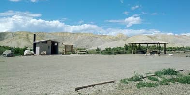
This is a staging area for OHVs no more than 50" in width. Site amenities include loading ramps, shade structures, picnic tables, trailer parking, training area, beginner loop, skills course, and vault toilets. The site is within the 900-acre Peach Valley OHV Open Play Area. Outside of open play areas all vehicles are required to stay on designated routes. For more information, please contact the Gunnison Gorge NCA or Uncompahgre Field Office.
Fee Info
OHV registration is required. Out of state visitors are required to obtain a Non-resident registration. Visitors to the Gunnison Gorge Wilderness Area will be charged the following user fees: Day Use Only (in and out the same day) = $3 per person. Day Use & Camping = $5 per person per calendar day. 1 night = $10. 2 nights = $15 (maximum allowable stay). Annual Pass for Day Use - $15 per /year. Fees apply to all users, 16 years of age and older, within the river canyon from the down-stream boundary of the Black Canyon of the Gunnison National Monument (2 miles upstream of the Chukar Put-In) down to, but not including, the Smith Fork confluence (10 miles downstream of the Chukar Put-In).
RV Road Trip Guides


Map & DirectionsPeach Valley OHV Recreation Area is located in Colorado near Olathe
Directions
From Olathe, Colorado travel 4.5 miles east on Falcon Road to the staging area. From Montrose: Head northwest out of town on N Townsend Ave/US-50 W approximately 9.2 miles to Falcon Rd. Turn east at Falcon Rd and follow approximately 3.8 miles where it curves slightly left into Peach Valley Rd. Continue approximately 0.7 miles to trail access.
Coordinates
38.59490192 N
107.88993728 W
Connectivity
 T-Mobile5GGood Coverage
 Verizon5GExcellent CoverageVerified by 4 usersLast on 7/16/26
- AT&T5GExcellent CoverageVerified by 4 usersLast on 7/16/26
Connectivity
- T-Mobile5GGood Coverage
- Verizon5GExcellent CoverageVerified by 4 usersLast on 7/16/26
- AT&T5GExcellent CoverageVerified by 4 usersLast on 7/16/26
Access
Site Types
- Tent Sites
Features
For Campers
- Reservable
- Toilets
Drive Time
- 1 hr 1 min from Grand Junction, CO
- 3 hrs 29 min from Farmington, NM
- 4 hrs 36 min from Colorado Springs, CO
- 4 hrs 46 min from Boulder, CO
