Bureau of Land Management operates Cochetopa Canyon Recreation Area along a creek corridor in southwestern Colorado. The campground spreads 10-15 sites across a four to five-mile stretch, with all sites positioned close to the access road. RVs up to 30 feet can navigate the area, though longer rigs may find maneuvering challenging given the linear layout.
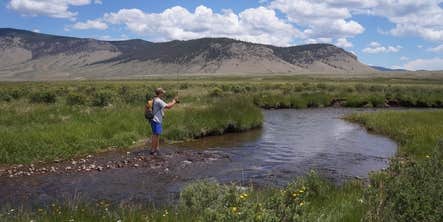
Sites sit within 20 feet of Cochetopa Creek, providing water access for fishing or cooling off. Restroom facilities appear every 100 yards or less along the corridor, and the campground includes ADA-accessible amenities. Cell service reaches most areas of the recreation site. The dispersed nature of sites along the creek means campers can find some separation despite the road proximity. Cochetopa Canyon offers a more concentrated camping experience just north for those preferring clustered sites.
Description
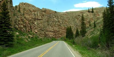
This scenic recreation area is a destination perfect for a day of fishing. The dense vegetation and steep canyon walls that line Cochetopa Creek provide a calm and relaxing place to fish with developed campsites and picnic areas located along the creek. Beautiful rock formations line Highway 114 and lead down to this little oasis located between Saguache and Gunnison. For more information, please contact the Gunnison Field Office. ADA Access: Restrooms and Shelters are ADA accessible.
Fee Info
No Fee
RV Road Trip Guides


Map & DirectionsCochetopa Canyon Recreation Area is located in Colorado near Powderhorn
Directions
From the town of Gunnison, drive east on Highway 50. Turn south on highway 114. The recreation site is a 4 mile stretch along both sides of State Highway 114 near mile marker 113.
Coordinates
38.30606143 N
106.76425897 W
Connectivity
 T-MobileNo Coverage
- VerizonNo Coverage
- AT&TNo CoverageVerified by 1 userLast on 7/25/26
Connectivity
- T-MobileNo Coverage
- VerizonNo Coverage
- AT&TNo CoverageVerified by 1 userLast on 7/25/26
Access
Site Types
- Tent Sites
Features
For Campers
- ADA Access
- Phone Service
- Toilets
Drive Time
- 2 hrs 43 min from Grand Junction, CO
- 3 hrs from Pueblo, CO
- 3 hrs 22 min from Colorado Springs, CO
- 4 hrs 52 min from Farmington, NM


