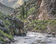
Boulder Ranger District, west of Boulder, offers camping in a region characterized by rugged terrain with forests and mountains. Temperatures range from lows in the 30s Fahrenheit in spring and fall to highs in the 80s during summer. Nearby attractions include the Flatirons and Eldorado Canyon State Park, providing opportunities for hiking and rock climbing.
Description
The Boulder Ranger District encompasses over one hundred thousand acres of the Front Range in western Boulder and northern Gilpin counties. The district includes Indian Peaks and James Peak Wilderness Areas and the Peak to Peak Scenic Byway. Many areas of the district are within an easy two-hour drive of Denver and its suburbs, making this one of the top recreation destinations in the state.
RV Road Trip Guides

Map & DirectionsBoulder Ranger District, west of Boulder is located in Colorado near Boulder
Directions
From I-25, exit west at Highway 119. Follow 119 to Boulder and exit Highway 119 west at Jay Road. Follow Jay Road west to Highway 36 and turn north on Highway 36. Go about one mile and watch for the Boulder Ranger District office on the east side of the highway. There is a Smokey Bear fire danger rating sign along Highway 36 in front of the building.
Coordinates
40.02942014 N
105.31001728 W
Connectivity
 T-Mobile5GExcellent Coverage
- Verizon5GExcellent CoverageVerified by 2 usersLast on 6/22/26
 AT&T5GGood CoverageVerified by 3 usersLast on 6/22/26
Connectivity
- T-Mobile5GExcellent Coverage
- Verizon5GExcellent CoverageVerified by 2 usersLast on 6/22/26
- AT&T5GGood CoverageVerified by 3 usersLast on 6/22/26
Access
Site Types
- RV Sites
Features
Drive Time
- 9 min from Boulder, CO
- 33 min from Denver, CO
- 58 min from Greeley, CO
- 59 min from Fort Collins, CO

