Dispersed camping near Oak View, California occurs primarily in Los Padres National Forest, where visitors find primitive camping with varying degrees of remoteness and accessibility. The region sits at elevations ranging from 1,000 to 5,000 feet, creating distinct microclimates that impact camping conditions throughout the year. Most primitive sites require adventure-minded campers willing to forgo standard amenities and pack in essentials.
What to do
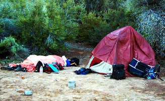
Waterfall exploration: The primitive Big Cone Camp - Santa Paula Canyon offers a reward for those willing to hike in. One visitor describes it as "a fairly easy hike through what would not be considered a typical hike" that winds "through Thomas Aquinas College, horse property and oil fields, before finally opening up into Santa Paula Canyon." From camp, visitors can reach the area known as the "punch bowls" with waterfalls and swimming holes.
Island backcountry hiking: The Santa Cruz Island - Del Norte Backcountry requires boat transportation and advance planning but offers unique hiking opportunities. One camper recommends to "take advantage and hike as far as you can—it's unreal! But bring a ton of water because you'll want it!" Another visitor mentioned they "hiked from Scorpion Harbor cross-island to Del Norte Camp, great way to see the island."
Wildlife observation: Several primitive campsites offer opportunities to observe local wildlife. At Santa Cruz Island, visitors frequently encounter the island fox. One camper noted, "Saw lots of island foxes - so cute!" but also warns to "use the food storage boxes to protect your food from the foxes." Wildlife sightings vary by season and location.
What campers like
Solitude and stargazing: The Carrizzo Plain National Monument Dispersed area provides excellent night sky viewing. A camper reported, "The stars were also quite visible with minimal light pollution." Another visitor appreciated that "despite the absence of trees or bushes for shadow, we had a wonderful evening here" and experienced "silent night with great views of the night sky."
Morning views: Some primitive sites offer scenic rewards for those willing to endure challenging access. At Morrow hill dispersed, a visitor noted they had a "great and quiet night up there in our 21ft RV" and experienced a "great view in the morning, beautiful."
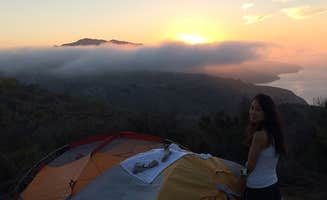
Unique camping experiences: The primitive camping options near Oak View provide distinctly different experiences based on location. One camper at Santa Cruz Island described their experience: "My friends and I took the cruise to Santa Cruz Island for a simple 1-night backpacking trip. It's only 4-miles from harbor to campsite, but it's mostly uphill." They added that "when we woke up everything was damp from the seaside fog. But the fog made the views quite lovely."
What you should know
Weather preparedness: Weather conditions can vary significantly across primitive camping areas near Oak View. At Carrizzo Plain, one camper warned it was "about 15 degrees (F) colder than was forecasted (20 F vs 35 F) at night, so be prepared to be a bit chilly if visiting during the winter." Wind can also be a factor at exposed sites.
Road conditions: Access to many dispersed sites requires navigating challenging roads. At Morrow hill dispersed, a camper cautioned "the road is a little tricky and we almost wouldn't have driven there" and advised to "make sure, you really stay at the place up the hill (coordinates) otherwise the landlord will clarify that you're on private property."
Camping restrictions: Not all areas permit dispersed camping. For the Los Padres NF - Dispersed Camp, one visitor clarified: "There is a nice hike-in campsite about 1.5 miles up the Chorro Grande trail called Oak Camp. I think the other review here might be unintentionally implying that camping along the 33 is allowed. It isn't." They quoted official rules: "Disperse camping is NOT allowed on Hwy 33, the Rose Valley Recreation Area or the Pine Mountain Recreation Area or Matilija Canyon Rd. These are Restricted Use Zones."
Tips for camping with families
Beginner-friendly backpacking: Some primitive sites near Oak View provide good introductory backpacking experiences for families. At Santa Cruz Island, a camper shared: "My friends were beginner backpackers so it was a bit tiring, but it was over quick and I still think it's a great trip for beginners."
Pack-in water requirements: When camping with children, water needs increase. For Santa Cruz Island backcountry camping, visitors emphasize water planning: "Note that there are gear restrictions for the cruise (check the website). Also you have to PACK YOUR OWN WATER."
Environmental awareness: The Figueroa Mountain Road Pullout 01 and other primitive sites require teaching children about environmental stewardship. At Big Cone Camp, a visitor urges: "Please pack out your trash. Because this hike is local and easy, there are many party people that frequent the area and leave their trash."
Tips from RVers
Clearance considerations: Several primitive camping areas near Oak View present challenges for RVs. One Morrow Hill camper with a 21-foot RV shared that "the road is a little tricky and we almost wouldn't have driven there," suggesting high-clearance vehicles are necessary for some sites.
Limited level parking: The terrain at many dispersed camping areas presents parking difficulties. At Figueroa Mountain Road Pullout 01, a visitor noted: "The site is all up hill and really only has a small area where a few vans can fit."
Site selection strategy: RV campers should scout locations before committing. At Carrizzo Plain, one visitor explained their approach: "Arrived on a drizzly day & tried going further down the road to other more secluded camping spots. However the dirt road was slick & minivan, loaded down, was slipping & sliding. Backtracked to a nice spot, camaflouged by a small hill."


 Ranger