Primitive camping near Angeles National Forest offers alternatives to established campgrounds for visitors seeking solitude. Free dispersed sites exist throughout the area, primarily along forest roads and designated pull-offs. Most locations lack basic amenities and require campers to pack out all trash and follow strict fire regulations during seasonal restrictions.
What to do
Hike nearby trails: Access several trailheads from Heaton flats dispersed area, which connects to the Bridge to Nowhere trail. "It could be an okay rest area at the beginning/end of the hike to Bridge to Nowhere," notes Les R.
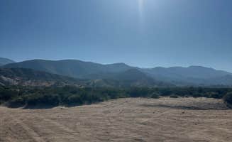
Explore with 4x4 vehicles: Stockton Flats Yellow Post Sites offers off-road opportunities for properly equipped vehicles. "If you go to the end of 3N06 (main off-road path) there is a good hike that you can take for several hours," suggests Nathaniel C.
Stargazing: Many dispersed sites offer clear night skies away from city light pollution. The higher elevation camping areas provide optimal conditions for astronomy enthusiasts when weather permits.
Wildlife observation: Dawn and dusk hours present opportunities to spot native wildlife including mule deer, coyotes, and various bird species throughout the forest's diverse elevations.
What campers like
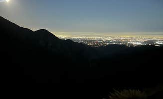
Scenic viewpoints: Angeles Crest Overlook offers panoramic vistas that many visitors appreciate. "The view is gorgeous in the morning sunrise!" reports Valerie.
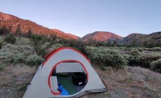
Remote locations: East Mojave Camp provides isolation for those seeking solitude. One camper notes it's "very remote absolutely nothing out there... Beautiful sunrise. We were the only people there."
Accessibility: Some areas permit overnight parking without requiring long hikes or special permits. "Quick stop friendly," mentions Joe R. about Rim of the World Byway dispersed camping.
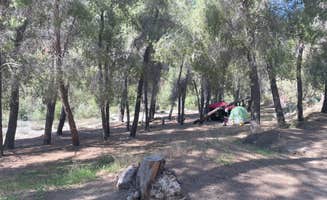
Shade options: Several dispersed sites feature tree cover for natural protection from summer heat. "The sites around has good shade and good size open spots," reports Panda V. about one camping area.
What you should know
Road conditions vary significantly: Access to many sites requires high-clearance vehicles. "The road to it is unmarked and very unmaintained. Would definitely recommend high clearance vehicle," warns Sawyer P. about East Mojave Camp.
Safety concerns at some locations: Angeles Crest sites experience regular traffic and activity throughout the night. "Kids do tend to party up here and drive about 100 miles an hour up and down the road all hours of the night," cautions Joseph R.
Unmarked access points: Finding some sites can be challenging. "The turn is not marked well, in fact the coordinates are a little bit off. If you miss the turn like we did you have to go 5 miles or more to get a turnabout," explains Joe R.
Cell service limitations: Coverage is unreliable throughout the forest. "Unfortunately I didn't have any service (Visible/Verizon), so that was a little scary," reports Jaydon C. about one overnight location.
Tips for camping with families
Choose sites away from highway overlooks: For families with children or dogs, roadside pullouts may present safety concerns. Nicole D. recommends: "If you have dogs I would recommend the trail pull off, my dogs really enjoyed the hike."
Prepare for minimal facilities: No toilets or water sources exist at most primitive sites. Bring sufficient water and portable sanitation solutions for overnight stays.
Consider weekday visits: Weekend traffic and noise can disrupt family camping experiences. "During the week it's more quiet," notes one camper about Angeles Crest areas.
Arrive early for best spots: Popular dispersed areas fill quickly during peak seasons. "Best to get there early as possible to secure a spot," advises Panda V.
Tips from RVers
Length restrictions: Many forest roads have tight turns unsuitable for larger rigs. "We decided not to go to the site because it looked like a one lane road and too tight for our 35 ft bumper pull," shares Joe R. about one attempted camping location.
Consider elevation changes: Steep grades can challenge larger vehicles. "You climb a big steep hill to get to the turn in. On the way back down from the turnaround we almost burned out our brakes," warns one RVer.
Level parking concerns: At roadside areas, finding sufficient level space for larger vehicles can be difficult. "This is literally just a roadside pull-off... No space for a tent. Sleep in your vehicle," notes Andrew S.
Alternative roadside spots: Some RVers find accessible locations near major routes. "If your headed north on I15 do not take first access road. Almost a 4x4 road," advises Gregg P. who successfully parked his TAB trailer at one site.


 Legend