Hikers seeking creek-side camping will find Oakwilde Trail Campground tucked along a waterway within Angeles National Forest. This US Forest Service site requires hiking in to reach, limiting crowds but also restricting vehicle access for gear transport.
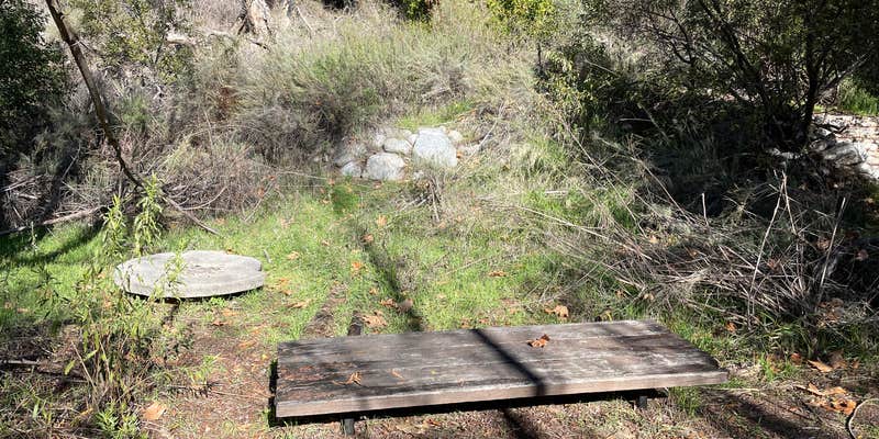
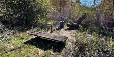
Recent visitors report flood damage has left the area in rough condition, with picnic tables partially buried and cooking surfaces covered in debris. The site offers firewood availability, though fire restrictions may apply. One reviewer noted only a single usable flat spot for tent setup when they visited in winter, with the creek running actively in January. Campers should prepare for primitive conditions and consider checking current site status before making the hike in, as maintenance appears limited at this remote location.
Description
1800-foot elevation. 5 hike-in campsites. 2 hitching rails. Stream water (treat before using). However, water flow may be low or non-existent due to reduced rainfall. Campsites are first come - first served. Interagency Pass or Adventure Pass required for vehicles parked at Switzer Picnic Area. Caution: Be alert for high water in the rainy season. Call (818) 899-1900, ext. 221 for current conditions and additional information.
Warning 1 Alert is In Effect
There is 1 alert for this campground. Camp safely!
Warning 1 Alert is In Effect
There is 1 alert for this campground. Camp safely!
Air Quality at this campground may currently be unhealthy for sensitive groups.
RV Road Trip Guides

Map & DirectionsOakwilde Trail Campground is located in California near La Cañada Flintridge
Directions
Location: From Interstate 210 in La Canada, exit Angeles Crest Hwy. (Hwy.2) and drive 9.5 miles north to Switzer's Picnic Area and hike down the trail 3 miles. Or exit Windsor/Arroyo off ramp in La Canada and go north to the intersection of Ventura St. Hike in from gated fire road 5 miles to Oakwilde.
Coordinates
34.24561245 N
118.18359955 W
Connectivity
 T-Mobile5GGood CoverageVerified by 3 usersLast on 7/30/26
 VerizonNo CoverageVerified by 1 userLast on 7/30/26
- AT&T5GGood Coverage
Connectivity
- T-Mobile5GGood CoverageVerified by 3 usersLast on 7/30/26
- VerizonNo CoverageVerified by 1 userLast on 7/30/26
- AT&T5GGood Coverage
Access
- Hike-InBackcountry sites.
Site Types
- Tent Sites
Features
For Campers
- Firewood Available
Drive Time
- 31 min from Los Angeles, CA
- 1 hr 10 min from Oxnard, CA
- 1 hr 33 min from Bakersfield, CA
- 2 hrs 10 min from San Diego, CA
