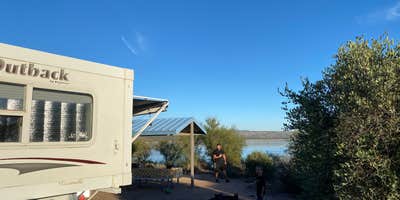
Tonto National Forest's Cholla Campground sits on the shore of Theodore Roosevelt Lake, central Arizona's largest lake, with open sightlines toward the Four Peaks Wilderness, Salome Canyon, and the Sierra Ancha mountain range. Managed by the US Forest Service, this large, solar-powered campground operates year-round and draws a mix of RV travelers, anglers, and paddlers who come specifically for lake access. The setting is forested with natural desert vegetation, including cactus and shrubs, giving perimeter sites a degree of separation that interior sites don't always share.
Campers consistently rate the facilities highly. Restrooms across the loops feature flush toilets and showers, and reviewers note the shower areas are cleaned daily. Each site has a covered picnic table ramada and a fire ring. Tara S. recalls spending a February night here and noted "saw lots of birds here: cactus wren, quail, finches, warblers, and road runners." Winter visits tend to be quieter, with weekends bringing more generator noise as the campground fills. Odd-numbered sites can be reserved in advance; even-numbered sites are first-come, first-served.
The campground includes a paved boat launch with a courtesy dock, making it a practical base for kayakers and anglers. Note that direct lake access from most campsites involves steep terrain, so the boat ramp is the most reliable route to the water. Swimming is not a designated activity here. A dump station is available, and the campground accommodates RVs up to 32 feet, though some sites are not accessible to larger rigs. Tenters who want waterfront proximity should look for walk-in sites near the lake. For pet-friendly camping near Tonto National Forest, Cholla is one of several options in the corridor, as leashed dogs are permitted throughout the campground.
Nearby alternatives include Cholla Bay to the south and Bachelor Cove, both on Roosevelt Lake. Campers who want a less developed experience can explore Bermuda Flat Recreation Site a short distance to the northwest. Spring and fall tend to draw larger crowds, particularly on weekends, so mid-week arrivals give campers a better shot at perimeter sites with lake views. Fees run $25 per night for a single unit and $50 for a double unit, with discounts available for America the Beautiful Senior and Access Pass holders.
Description
Overview
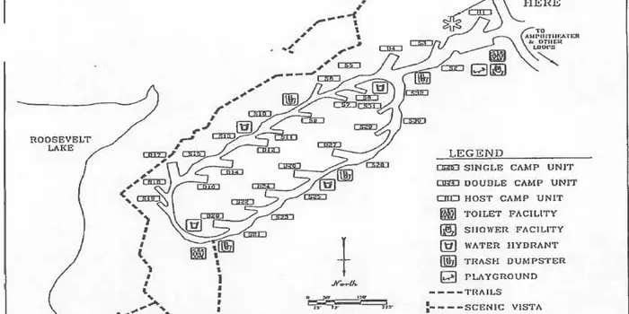
Cholla Campground at Roosevelt Lake, is one of several campgrounds on the shores of the largest lake/reservoir located entirely in the State of Arizona. It is situated within a lush sonoran desert landscape at an elevation of 2168'. Each of its 206 campsites have shade ramadas, firepits, grills, and picnic tables. Playgrounds, showers and toilet facilites are scattered throughout the campground. The area around Cholla Campground is often alive with abundant wildlife such as mule deer, coyotes, geese, fox, javalina, and the occasional bald eagle.
Recreation
Recreation opportunities abound at Cholla Campground. Launch your bass boat, ski boat, or pontoon boat from the developed boat ramps within the recreation site and play on the water all day long. If motorsports aren't your thing, there's an abundance of places to explore from your kayak, canoe, or paddleboard. While you're visiting, you can also hike a portion of the Arizona Trail, visit the Tonto National Monument cliff dwellings, explore endless miles of jeep trails or drive a portion of the Apache Trail or Spines to Pines Highway. If if you're looking for a day in town, consider the easy 45 minute drive Globe or Payson where you can shop for antiques, buy ice cream and learn about Arizona's rich mining and timber history. Roosevelt Lake is a landscape photograhers dream so don't forget your camera (and sunscreen).
Facilities
__Cholla Campground has 206 campsites. Each site has shade ramadas, firepits, grills, and picnic tables. Scattered throughout the campground are playgrounds, showers and toilet facilites. Highly developed boat ramps with accessible boat boarding ramps are also available within the Campground.
Natural Features
Roosevelt Lake was dedicated by President Theodore Roosevelt in 1911 and boasts 112 miles of shoreline and peaceful coves. When full, the lake provides 21,500 acres of surface water for your recreating pleasure. Cholla Campground is situated within a Sonoran Desert Landscape along the lakes shorelines. Views of the blue water and sunsets against the Sierra Ancha, Salome, and Superstition Wilderness' are a sight that keep many visitors coming back year after year.
Nearby Attractions
Two National Scenic Byways (AZ Hwy 88 Apache Trail and AZ Hwy 288 Spines to Pines Highway). Roosevelt Dam, Tonto National Monument, the Arizona Trail, endless miles of jeep trails, Towns of Payson and Globe, Superstition, Sierra Ancha, and Four Peaks Wilderness'. Don't forget to stop by the Tonto Basin Environmental Center learn about the history of the area.
Warning 2 Alerts are In Effect
There are 2 alerts for this campground. Camp safely!
Warning 2 Alerts are In Effect
There are 2 alerts for this campground. Camp safely!
Cholla Campground will be seasonally closed starting June 1. We will reopen this campground in October. Thank you for your understanding. Tonto National Forest, Tonto Basin Ranger District.
Stage 2 fire restrictions are currently in effect that prohibit all fires. Generators and fires or stoves that use liquid petroleum (LPG) fuels are permitted, but must follow specific rules.
RV Road Trip Guides


Map & DirectionsRoosevelt Lake is located in Arizona near Roosevelt
Directions
Cholla Campground is 5 miles north of Roosevelt Dam. From Mesa: Take State Hwy. 87/Beeline Highway north for about 60 miles to its junction with State Hwy. 188. Turn right and follow State Hwy. 188 south for 28 miles to the site. From the Globe area: Take State Hwy. 188 north for 30 miles to its junction with State Hwy. 188. Continue on State Hwy. 188 across the bridge for 6 miles to the site.
Address
28079 N. AZ HWY 188
Roosevelt, AZ 85545
Coordinates
33.73151 N
111.203798 W
Connectivity
 T-MobilePossible CoverageVerified by 33 usersLast on 7/28/26
 VerizonLTEGood CoverageVerified by 37 usersLast on 7/28/26
 AT&T5GExcellent CoverageVerified by 4 usersLast on 7/28/26
Connectivity
- T-MobilePossible CoverageVerified by 33 usersLast on 7/28/26
- VerizonLTEGood CoverageVerified by 37 usersLast on 7/28/26
- AT&T5GExcellent CoverageVerified by 4 usersLast on 7/28/26
Access
- Drive-InPark next to your site
- Walk-InPark in a lot, walk to your site.
- Boat-InSites accessible by watercraft.
Site Types
- Tent Sites
- RV Sites
- Standard (Tent/RV)
- Group
Features
For Campers
- Trash
- Picnic Table
- Firewood Available
- Phone Service
- Reservable
- Drinking Water
- Toilets
- Alcohol
- Pets
- Fires
For Vehicles
- Sanitary Dump
- Big Rig Friendly
Drive Time
- 1 hr 39 min from Phoenix, AZ
- 2 hrs 13 min from Prescott Valley, AZ
- 2 hrs 23 min from Flagstaff, AZ
- 2 hrs 38 min from Tucson, AZ


