Accessible via gravel roads that can be rough in places, Esterbrook Campground provides 15 sites within Medicine Bow National Forest at elevations around 7,000 feet. The Forest Service facility accommodates RVs up to 51 feet with water hookups available, though sites vary in size and accessibility. Reservations can be made in advance, with nightly rates ranging from $20-$65 depending on site selection and amenities.
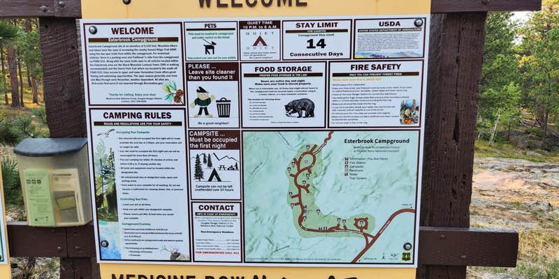
The campground features a loop design with sites set back from the main road, offering spacing between neighbors. Each site includes a picnic table, fire ring, and parking area on dirt and gravel surfaces. A hand-operated water pump provides drinking water during operating season, while vault toilets serve the campground. Fred S. found his site "set back from campground road" with "large backyards behind sites."
The Sunset Hill hiking trail begins directly from the campground, leading to elevated viewpoints overlooking the surrounding mountains and forest. T-Mobile cellular service reaches the area, though coverage may vary by carrier. Sites remain relatively quiet due to the campground's location away from major highways. Fishing opportunities exist along nearby waterways accessible by foot.
Campers should bring adequate water supplies as backup, since the hand pump may not operate during winter months. The facility works well for both tent camping and RV stays, particularly for those seeking forest camping with basic amenities and trail access.
Description
Overview
Esterbrook Campground is nestled within a pine forest along a broad ridge north of Laramie Peak. A favorite of both RV and tent campers, it is a terrific jumping-off point for recreating in the Laramie Peak Unit of the Douglas Ranger District. The campground is popular for OHV riding, fishing, hiking, hunting, and mountain biking.
Recreation
Recreation The Laramie Peak area in the Medicine Bow National Forest is located in Central Wyoming. The Douglas Ranger District manages the Laramie Peak and Thunder basin National Grasslands areas. Year-round recreation uses include hiking, fishing, hunting, OHV riding, camping, biking and horseback trail riding. Primary access across the district is by I-25 and Highway 59. Mountain Biking Upper Roaring Fork Trail Friend Park Trail North Laramie River Trail Harris Park Trail Laramie Peak Trail Sunset Ridge Trail Lost Creek Trail Albany Peak Trails Black Mountain Look out Mountain Climbing Curtis Gulch Trail Day Hiking Upper Roaring Fork Trail Friend Park Trail North Laramie River Trail Harris Park Trail Laramie Peak Trail Sunset Ridge Trail Lost Creek Trail Albany Peak Trails Black Mountain Look out Backpacking Upper Roaring Fork Trail North Laramie River Trail Harris Park Trail Lost Creek Trail Albany Peak Trails Horseback riding Upper Roaring Fork Trail Friend Park Trail North Laramie River Trail Harris Park Trail Laramie Peak Trail Sunset Ridge Trail Lost Creek Trail Black Mountain Look out Horseback riding Upper Roaring Fork Trail Friend Park Trail North Laramie River Trail Harris Park Trail Laramie Peak Trail Sunset Ridge Trail Lost Creek Trail Albany Peak Trails Black Mountain Look out OHV Riding FSRD633 Trails Sunset Ridge Trail North Laramie River Trail Laramie Peak Trail Albany Peak trails Black Mountain Look out
Facilities
There are 12 campsites in a lightly wooded, rocky area with picnic tables, fire rings, pedestal grills, vault toilets, trash collection, and potable water. Most campsites have a dispersed feel as they are widely spaced apart. Potable water is typically available in this campground from mid-May to late November. These dates may vary due to weather. Potable water availability may vary due to well and/or pump maintenance, and water testing requirements. As such, we encourage you to bring your own potable water or call ahead.
Natural Features
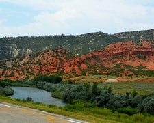
Located at an elevation of 6,300 feet, the campground sits in an open forest of ponderosa pine. The Laramie Peak Unit of the Medicine Bow-Routt National Forests and Thunder Basin National Grassland encompass approximately 352,000 acres of the Laramie Range in central Wyoming. Mule deer, elk, black bear, whitetail deer, antelope, bald eagles, gos hawks, bobcat, coyote, big horned sheep, yellow-bellied marmots, and mountain lions are just some of the many animals that inhabit the diverse lands on Laramie Peak.
Nearby Attractions
Visitors can find many outdoor opportunities in the surrounding area including OHV riding, hiking, backpacking, mountain biking, hunting, fishing, sightseeing, photography, and horseback riding. Fishing opportunities nearby at Lower Horseshoe Creek. Sunday services available nearby at the historic Esterbrook Community Church (non-denominational).
Charges & Cancellations
If I book this reservation today, what are my options to change or cancel? Please remember that reservations at these facilities prevent other visitors from using these sites. Planned changes to your stay should be made as far in advance as possible. You can make changes to your reservation ahead of your arrival date in My Reservations. Changes If your new stay dates are completely different from your original stay dates, there is a $10 change fee (per reserved site). There are no additional fees for: Adding or removing nights to your stay. Changing to a different campsite. Balances will adjust based on your new stay's nightly rate. Cancellations You can cancel the reservation any time before the date of your scheduled arrival. You will receive a refund for your stay, minus the following fees: $10 cancellation fee Any reservation fees (only if paid when booking) Any previous change fees Late cancellation penalties may also apply: What is _ Late _? For individual campsites, a late cancellation applies starting from midnight 1 calendar day before your scheduled check-in. For cabins and group sites, a late cancellation applies starting from midnight 14 calendar days or fewer before your scheduled check-in. Late Fee In addition to the fees listed above, a late cancellation will also subtract your first night's recreation use fee from any refund owed. As of the expected check-in day, cancellations or changes to your stay are not possible through My Reservations. It is at the facility's discretion to support additional Late Cancellations, No Show, or Early Departure updates on-site personnel may not be able to assist. These changes carry penalties and may forfeit recreation use fees. For additional details, please visit here. Scan and Pay Rules The above guidance for modifications, cancellations, and refunds do not apply to campsites reserved using the Scan and Pay feature. There are no refunds, modifications, cancellations, or other fee changes allowed with Scan and Pay payments. This system is the same as putting cash into a fee tube and cannot be refunded.
Fee Info
$20/night Single $40/night Double $65/night Group
RV Road Trip Guides

Map & DirectionsEsterbrook Campground is located in Wyoming near Glendo
Directions
Campground is approximately 3 miles east of Esterbrook, WY on Forest Service Road 633. From I25 North Douglas, WY (30 miles) - take Highway 94 which turns into County Road 5 (Esterbrook Road) south for 27 miles, then 3 miles east on Forest Road 633. From I25 South- Take Glendo exit and go west on CR6 for 20 miles to CR5, then south 2 miles to Esterbrook. Go east 3 miles on FS 633 to the campground. The roads are well signed and easily accessible to automobiles of all types.
Coordinates
42.4222 N
105.3216 W
Connectivity
 T-MobileLTESome Coverage
- VerizonLTESome CoverageLast on 5/16/26
 AT&T5GExcellent Coverage
Connectivity
- T-MobileLTESome Coverage
- VerizonLTESome CoverageLast on 5/16/26
- AT&T5GExcellent Coverage
Access
- Drive-InPark next to your site
Site Types
- Tent Sites
- RV Sites
- Standard (Tent/RV)
- Group
Features
For Campers
- Trash
- Phone Service
- Reservable
- Drinking Water
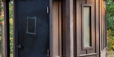
- Toilets
- Pets
- Fires
For Vehicles
- Water Hookups
Drive Time
- 1 hr 45 min from Casper, WY
- 2 hrs 8 min from Cheyenne, WY
- 2 hrs 44 min from Fort Collins, CO
- 2 hrs 58 min from Greeley, CO


