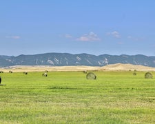
Unlock Planning Tools in App
pro

Free Camping Collection

Dispersed Camping

Salt river public access

CAMPER SUMMARY PRESENTED BYFord

Salt River Public Access in Wyoming offers a landscape of open spaces with river access. Temperatures range from lows in the 20s Fahrenheit during winter to highs in the 80s during summer. Nearby, visitors can explore the Bridger-Teton National Forest and enjoy activities such as fishing and hiking.

Suggest an Edit

Location

Salt river public access is located in Wyoming

Detail location of campground

Coordinates

42.9748282 N
110.96836018 W

Open in Google Maps

Connectivity

Presented byT-Mobile SatelliteT-Mobile is introducing T-Satellite to extend coverage in the outdoorsLearn More
  • signal strength bars
    T-Mobile5G
    Excellent Coverage
  • signal strength bars
    VerizonLTE
    Some Coverage
    Verified by 2 users
  • signal strength bars
    AT&TLTE
    Some Coverage

Drive Time

Presented byToyota Trucks

Connectivity

Presented byT-Mobile SatelliteT-Mobile is introducing T-Satellite to extend coverage in the outdoorsLearn More
  • signal strength bars
    T-Mobile5G
    Excellent Coverage
  • signal strength bars
    VerizonLTE
    Some Coverage
    Verified by 2 users
  • signal strength bars
    AT&TLTE
    Some Coverage

Access

  • Drive-In
    Park next to your site

Site Types

  • Dispersed

Features

For Campers

  • Phone Service
  • Toilets
  • Alcohol
  • Pets
  • Fires

DISPERSED CAMPING

Enjoy dispersed camping on government land and leave no trace. Pack in and pack out. No (or limited) services at this camping area. Permit may be required.


PERMIT might be REQUIRED

We curate permit requirements across the US for our PRO members. Try PRO to see if Salt river public access needs a permit.

Contact

General Info


2025 Detourist Giveaway

Presented byToyota Trucks

Review Campgrounds. Win Prizes.

Enter to Win

Reviews

Add Review

5 Stars

4 Stars

3 Stars

2 Stars

1 Star

0%
0%
50%
0%
50%

2.0

out of 5

2 Reviews

Reviewed Oct. 4, 2020

Directions are not valid

Tried to get here via both Google Maps & and Waze. Both sent us into the middle of a neighborhood of homes. If it had been daytime, we might have had a chance winging it.

Frequently Asked Questions

Where can I find public access points for camping along the Salt River in Wyoming?

Public access points for camping along the Salt River in Wyoming can be found in the riverfront areas that offer camping opportunities. Finding these locations can be challenging as navigation apps like Google Maps may not provide accurate directions. It's advisable to use official Wyoming Game and Fish Department resources or local visitor centers for accurate access information. When planning your trip, consider reaching out to local ranger stations or checking Wyoming's official outdoor recreation websites for the most reliable directions to public access points.

What are the main features of Salt River campground in Wyoming?

The Salt River campground in Wyoming features large, open campsites situated along the riverfront, providing direct access to the water. The sites lack shade trees, so prepare accordingly with sun protection during summer months. The campground's layout offers a rustic experience with minimal development, making it suitable for those seeking a more natural setting. The river proximity makes this location appealing for fishing enthusiasts and water activities. Navigation to the campground can be challenging, so planning your route carefully and possibly arriving during daylight hours is recommended for first-time visitors.

Is there a map of Salt River campground and fishing areas in Wyoming?

Maps of the Salt River campground and fishing areas in Wyoming are available through the Wyoming Game and Fish Department, which manages public access to these waters. Digital maps can be found on Wyoming's official state recreation websites. Physical maps are typically available at local ranger stations and visitor centers in the area. For fishing-specific information, check the Wyoming fishing regulations guide, which often includes access point details. Since navigation to these areas can be tricky, obtaining an official map before your trip is highly recommended.