
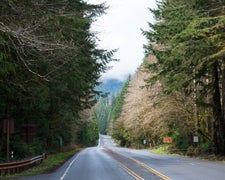
Managed by Washington State Department of Natural Resources, Suiattle River Road - Forest Service Road 26 sits in forested terrain near the Suiattle River, northeast of camping near Darrington. Access is rough. One reviewer notes the road has no pull-outs along the side, with a large open field further past the marked location and downed trees on the dead-end loop. High-clearance vehicles are required, pets are not permitted, and cell service is unreliable. Come prepared with offline maps and confirm road conditions before heading out.
Description
The Suiattle River Road is located northeast of Darrington and is a major route into the Glacier Peak Wilderness, accessing the Pacific Crest Trail and roughly 120 miles of hiking trails within the Suiattle River Watershed. The road provides scenic and pleasure driving and allows people to access areas to hunt, search for wild mushrooms, pick berries and gather other forest products. Tribal members use the road to reach areas and resources important for traditional cultural practices and exercise reserved Treaty rights. Suiattle River Recreation Area Map
RV Road Trip Guides

Map & DirectionsSuiattle River Road is located in Washington near Darrington
 Public Campground
Directions
Follow State Route 530 east and then north out of Darrington, turn right onto Forest Service road 26 after crossing the Sauk River.
Coordinates
48.34957694 N
121.45535928 W
Connectivity
 T-MobileNo Coverage
- VerizonNo Coverage
- AT&TNo Coverage
Connectivity
- T-MobileNo Coverage
- VerizonNo Coverage
- AT&TNo Coverage
Access
Site Types
- Tent Sites
Features
Drive Time
- 1 hr 19 min from Mount Vernon, WA
- 1 hr 32 min from Bellingham, WA
- 1 hr 43 min from Seattle, WA
- 2 hrs 40 min from Bremerton, WA


