Managed by the US Army Corps of Engineers, this 20-site campground sits where the Priest River meets Lake Pend Oreille, offering electric hookups and accommodating RVs up to 72 feet. Reservations through Recreation.gov run from May through September, with nightly rates ranging from $10 to $75 depending on site selection and amenities.
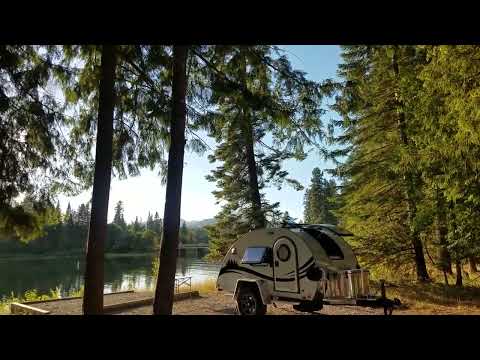
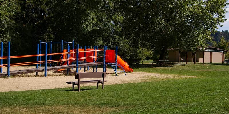
Campers find themselves in a forested setting with well-spaced sites tucked among large conifers. Site 12 draws particular attention as the only waterfront tent-only spot, positioned directly on the river with sunrise and sunset views. However, Todd B. notes "other sites don't have the view so the road noise would be even more annoying," pointing to the campground's proximity to the highway. The adjacent public beach and day-use area brings foot traffic past waterfront sites, though most reviewers appreciate having the swimming area and playground nearby.
Fishing opportunities center on the river confluence, with campers reporting active fish jumping during calm morning and evening hours. The on-site boat dock provides direct water access, while flush restrooms include hot showers at five minutes per quarter. A dump station serves RV campers, and firewood sales keep evening campfires going. Rangers occasionally present educational programs on local flora.
Road noise affects all sites due to the campground's edge-of-town location, though the forested buffer provides some screening. Stephanie B. mentions "mosquitoes and you can hear some road noise" as the main drawbacks. The entrance gate closes from 10 PM to 7 AM, requiring early arrival or late departure planning. Nearby Albeni Cove and Riley Creek Campground offer alternatives within the same lake system.
This campground works well for RV travelers wanting full hookups near town amenities, families with children who'll use the beach and playground, and anglers focused on the river confluence fishing.
Description
Overview
Priest River Campground is situated on the banks of Priest River, shaded by firs, cedars and pines, just upstream from the confluence of the Pend Oreille River.
Recreation
Water activities are popular at the campground including kayaking, fishing and swimming. The day-use area includes a picnic shelter, playground, softball field, swim beach, boat ramp and a large grassy area for family fun . Adjacent to the campground is the Priest River Wildlife area, offering excellent fishing as well as birding. Wildlife in the area includes bald eagles, osprey, a wide variety of birds, and deer.
Facilities
Priest River Campground offers 20 campsites with amenities such as flush toilets and hot showers.
Natural Features
Albeni Falls Dam was built in 1955 for flood control and power production on the Pend Oreille River. Today, the popular lake has the added benefit of providing visitors with countless year-round recreational activities. Lake Pend Oreille is surrounded by scenic mountains and is one of the largest and deepest natural lakes in the western United States, plunging to depths of more than 1,200 ft. in some areas. Behind the dam, the Pend Oreille River stretches 65 miles through a glacial-carved valley that separates three mountain ranges.
Nearby Attractions
The Albeni Falls Visitor Center features exhibits on the history of the dam and the natural features of the area. Tours of the dam are given daily during the summer. The nearby town of Priest River, Idaho, offers gas and grocery services.
Warning 1 Alert is In Effect
There is 1 alert for this campground. Camp safely!
Warning 1 Alert is In Effect
There is 1 alert for this campground. Camp safely!
Boat launches are currently closed until Lake Pend Oreille reaches an elevation of 2058ft. Lake elevations can be tracked at https://water.sec.usace.army.mil/overview/nws/locations/alf
RV Road Trip Guides

Map & DirectionsPriest River is located in Idaho near Newport
Directions
Priest River Recreation Area is 1 mile east of the town of Priest River on Highway 2. After the river it will be the first road on the right. The park is also known as the \"Mudhole.\"
Address
2376 E HWY2
Oldtown, ID 83822-9243
Coordinates
48.1791667 N
116.8922222 W
Connectivity
 T-Mobile5GExcellent CoverageVerified by 4 usersLast on 6/14/26
 VerizonLTESome CoverageVerified by 8 usersLast on 6/14/26
- AT&T5GExcellent Coverage
Connectivity
- T-Mobile5GExcellent CoverageVerified by 4 usersLast on 6/14/26
- VerizonLTESome CoverageVerified by 8 usersLast on 6/14/26
- AT&T5GExcellent Coverage
Access
- Drive-InPark next to your site
- Walk-InPark in a lot, walk to your site.
- Boat-InSites accessible by watercraft.
Site Types
- Tent Sites
- RV Sites
- Standard (Tent/RV)
- Group
Features
For Campers
- Trash
- Picnic Table
- Firewood Available
- Phone Service
- Reservable
- Drinking Water
- Electric Hookups
- Toilets
- Alcohol
- Pets
- Fires
For Vehicles
- Sanitary Dump
- Pull-Through Sites
- Big Rig Friendly
Drive Time
- 58 min from Coeur d'Alene, ID
- 1 hr 7 min from Spokane, WA
- 2 hrs 50 min from Lewiston, ID
- 3 hrs 40 min from Walla Walla, WA