Arkansas State Parks operates Lake Charles State Park, which encompasses a 645-acre lake and this year-round campground near Powhatan. The park sits along narrow country roads that require careful navigation, particularly for larger RVs, though the journey leads to three distinct camping areas with varying amenities.
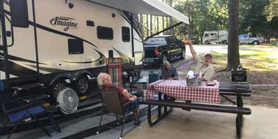
Loop C provides the most comprehensive hookups with water, 50-amp electric, and sewer connections, while Loops A and B offer 30-amp electric and water. Sites accommodate RVs up to 60 feet, though some spaces prove tighter than advertised. Carrie B. notes "some sites have water, 50 amp electricity and sewer hook up while the others have 30 camp electricity and water." Lakefront sites in Loop C command premium positions but may lack adequate shade during summer months.
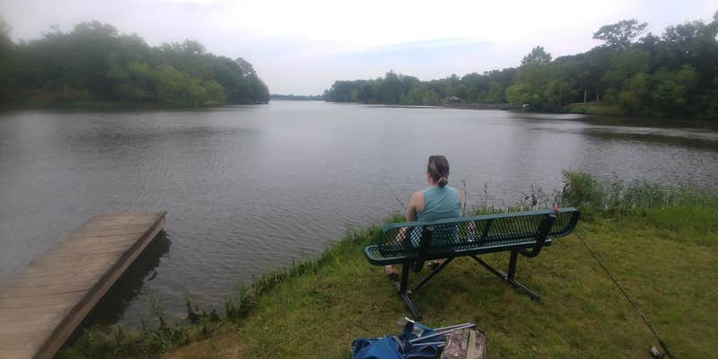
The 645-acre lake supports bass, crappie, bream, and catfish fishing, with a dedicated fishing pier accessible via paved path from the campground. Four hiking trails wind through the property, including the paved Cedar Trail and the shorter Butterflies and Blooms Trail. A designated swimming area features a gently sloping sandy beach, though no lifeguards are present. The visitor center stocks bait and tackle from March through October, while a 3-D archery range operates during winter months.
Access requires navigating narrow rural roads without shoulders, which several reviewers mention as challenging for large RVs. Modern restrooms and bathhouses provide air conditioning—a notable comfort during Arkansas summers. However, campers should prepare for seasonal insect activity, particularly flies and mosquitoes during warmer months. The single trash collection point is located at the dump station, requiring a walk from most sites.
For additional camping options in the region, consider Davidsonville Historic State Park Campground eight miles northeast. Reservations are accepted for all sites, and the park welcomes pets throughout its wooded setting.
RV Road Trip Guides


Location
Public CampgroundLake Charles State Park Campground is located in Arkansas
Directions
From Hoxie, go eight miles northwest on U.S. 63, then six miles south on Ark. 25 to the park.
Address
3705 Highway 25
Powhatan, AR 72458
Coordinates
36.06522921 N
91.15307018 W
Connectivity
 T-MobileNo Coverage
 VerizonLTESome CoverageVerified by 4 usersLast on 3/30/26
- AT&TLTESome CoverageVerified by 2 usersLast on 3/30/26
Connectivity
- T-MobileNo Coverage
- VerizonLTESome CoverageVerified by 4 usersLast on 3/30/26
- AT&TLTESome CoverageVerified by 2 usersLast on 3/30/26
Access
- Drive-InPark next to your site
Site Types
- Standard (Tent/RV)
- Yurts
Features
For Campers
- Market
- ADA Access
- Trash
- Picnic Table
- Firewood Available
- Reservable
- WiFi
- Showers
- Drinking Water
- Electric Hookups
- Toilets
- Alcohol
- Pets
- Fires
For Vehicles
- Sanitary Dump
- Sewer Hookups
- Water Hookups
- Pull-Through Sites
- 50 Amp Hookups
- Big Rig Friendly
Drive Time
- 41 min from Jonesboro, AR
- 1 hr 43 min from Memphis, TN
- 2 hrs 2 min from Little Rock, AR
- 2 hrs 35 min from Cape Girardeau, MO