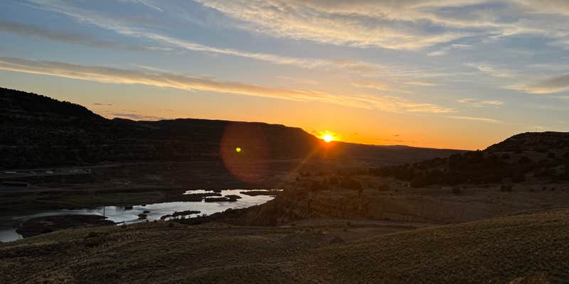
Where the San Juan River feeds into Navajo Lake, Pine Main Campground sits at 6,000 feet elevation within New Mexico's largest state park. The campground provides full hookups for RVs up to 30 feet, though James F. notes that "several of the sites are uneven" and recommends bringing leveling materials. Sites are compact and positioned close together, with some offering direct views across the water toward the marina.
The facilities earn consistent praise from visitors. Restrooms receive regular cleaning, and the marina operates within a five-minute drive for boat rentals, supplies, and propane refills. Two trails descend from certain sites directly to the lake, though the walk involves steep and rocky terrain. The campground operates year-round, with seasonal crowd patterns that shift from busy summer months to quieter off-season periods.
Campers should prepare for sticker burrs throughout the area and limited cell service at this elevation. The Cottonwood Campground — Navajo Lake State Park offers an alternative without hookups for those preferring a more dispersed camping experience.
Description
Navajo Lake is the second largest lake in the state, with multiple campgrounds, two marinas, and two boat docks.
Navajo Lake is a haven for boaters of every stripe – motorized boaters, canoers, kayakers, water skiers, and sailors. The San Juan River is a world-class fly-fishing destination and features a campground, day-use areas, and a serene trail along the river.
Navajo Lake State Park offers some of the best boating, fishing, hiking, and camping in New Mexico.
Warning 8 Alerts are In Effect
There are 8 alerts for this campground. Camp safely!
Warning 8 Alerts are In Effect
There are 8 alerts for this campground. Camp safely!
The use of off-highway motor vehicles (OHVs) is prohibited in New Mexico State Parks, as stipulated by the NM OHV Act and State Park Regulations (NMSA 66-3-1011, 16-2-33 19 NMAC Ch 5 Sec 2.16 A).
**IMPORTANT INFORMATION ABOUT YOUR DRINKING WATER** **BOIL WATER ADVISORY** **Navajo Lake State Park Sims Mesa Campground** **Does Not Meet Treatment Requirements** **Este informe contiene información importante acerca de su agua potable. Haga que alguien lo traduzca para usted, o hable con alguien que lo entienda.** Our water system recently violated a drinking water requirement. As our customers, you have a right to know what happened, what you should do, and what we did (are doing) to correct this situation. We routinely monitor your water for turbidity (cloudiness). This tells us whether we are effectively filtering the water supply. Water samples for August 2024 showed that turbidity measurements were over 1 turbidity unit (NTU) and several over 0.3 NTU. The standard is that no samples may exceed 1 turbidity unit (NTU). This is a violation of the requirements of the Safe Drinking Water Act and indicates an elevated threat to public health. **What should I do?** - **BOIL WATER FOR AT LEAST 3 MINUTES BEFORE USING, OR SEEK AN ALTERNATE SOURCE.** - If you have a severely compromised immune system, have an infant, are pregnant, or are elderly, you may be at increased risk and should seek advice from your health care providers about drinking this water. General guidelines on ways to lessen the risk of infection by microbes are available from EPA’s Safe Drinking Water Hotline at 1-800-426-4791. **What does this mean?** _*Turbidity has no health effects. However, turbidity can interfere with disinfection and provide a medium for microbial growth. Turbidity may indicate the presence of disease causing organisms. These organisms include bacteria, viruses, and parasites which can cause symptoms such as nausea, cramps, diarrhea, and associated headaches.*_ These symptoms are not caused only by organisms in drinking water. If you experience any of these symptoms and they persist, you may want to seek medical advice. **What is being done?** We are actively ensuring that the system is operating within parameters and will re-test as soon as possible to esnure the system is in compliance. **For more information, please contact:** Victoria Gurule, Park Manager,victoria.gurule@emnrd.nm.gov, (505) 592-9852. _*Please share this information with all the other people who drink this water, especially those who may not have received this notice directly (for example, people in apartments, nursing homes, schools, and businesses). You can do this by posting this notice in a public place or distributing copies by hand or mail.*_
Make it your goal to extinguish hot coals. If your campfire is too hot to touch, it's too hot to leave. Drown it with water, stir it with a shovel, and repeat until your campfire is out cold! Learn more from Smokey Bear.
Please bring proof of your reservation with you to your campsite.
Building, maintaining, attending or using a fire, campfire, charcoal, coal, or wood stove is prohibited. The use of devices fueled solely by liquid petroleum or LPG fuels that can be turned on and off is allowed. Such devices can only be used in an area that is barren or cleared of all overhead and surrounding flammable materials within three (3) feet of the device. Smoking is prohibited, except within an enclosed vehicle or building.
**Park staff may move your reservation to a different site in cases of inclement weather or site inaccessibility.**
County Road 4280, leading to Cottonwood Campground, has been negatively impacted by heavy rains and may be difficult to traverse. Visitors, especially those bringing large camping units, should exercise caution when traveling to the campground and day-use areas via CR 4280.
THE CUSTOMER MUST CONTACT THE PARK TO ADVISE THEM OF LATE ARRIVAL THE SITE WILL BE RELEASED FOR RESERVATIONS / FIRST COME, FIRST SERVED ON THE SECOND DAY AFTER 4:00 P.M.. NO REFUND WILL BE DUE.
RV Road Trip Guides


Map & DirectionsPine Main Campground is located in New Mexico near Navajo Dam
Directions
Pine Main Camping Areas: FROM BLOOMFIELD NM TRAVEL 25 MILES NORTHEAST VIA US64 AND NM511. FROM AZTEC NM TRAVEL 25 MILES NORTHEAST VIA NM173 AND NM511. FROM DULCE NM TRAVEL 55 MILES NORTHWEST VIA US64, NM539 AND NM511. FROM IGNAICIO CO TRAVEL 26 MILES SOUTH VIA CO172 AND NM511. Cottonwood Camping Areas: FROM BLOOMFIELD NM TRAVEL 9 MILES EAST VIA US64 TO NM511 - 9 MILES TO NM173 - WEST 1 MILE TO CR4280. FROM AZTEC NM TRAVEL 25 MILES VIA US550N TO NM173 - 18 MILES TO CR4280. FROM DULCE TRAVEL 55 MILES VIA US64 AND NM511 TO CR428. FROM IGNACIO CO TRAVEL 26 MILES SOUTH VIA CO172 AND NM511 TO CR4280. Sims Mesa Camping Areas: FROM BLOOMFIELD NM TRAVEL 64 MILES NORTHEAST VIA US64 AND NM527. FROM AZTEC NM TRAVEL 18 MILES NORTHEAST VIA NM173 - 5 MILES NORTH VIA NM511 - 5 MILES SOUTH VIA NM539 - 24 MILES NORTH VIA US64 - 17 MILES NORTH VIA NM527. FROM CHAMA NM TRAVEL 66 MILES NORTHWEST VIA US64 - 17 MILES NORTH VIA NM527. FROM IGNACIO CO TRAVEL SOUTH 25 MILES VIA CO172/NM511 - 5 MILES SOUTH VIA NM539 - 24 MILES NORTH VIA US64 - 17 MILES NORTH VIA NM527.
Address
1448 NM HWY 511 # 1
Navajo Dam, NM 87419
Coordinates
36.81749086 N
107.61650155 W
Connectivity
 T-Mobile5GExcellent CoverageVerified by 6 usersLast on 6/18/26
 VerizonLTEGood CoverageVerified by 19 usersLast on 6/18/26
- AT&T5GGood CoverageVerified by 9 usersLast on 6/18/26
Connectivity
- T-Mobile5GExcellent CoverageVerified by 6 usersLast on 6/18/26
- VerizonLTEGood CoverageVerified by 19 usersLast on 6/18/26
- AT&T5GGood CoverageVerified by 9 usersLast on 6/18/26
Access
- Drive-InPark next to your site
Site Types
- Tent Sites
- RV Sites
- Standard (Tent/RV)
- Group
Features
For Campers
- Reservable
- WiFi
- Electric Hookups
- Toilets
- Alcohol
- Pets
- Fires
For Vehicles
- Sanitary Dump
- Sewer Hookups
- Water Hookups
- Pull-Through Sites
- 30 Amp Hookups
- 50 Amp Hookups
- Big Rig Friendly
Drive Time
- 46 min from Farmington, NM
- 3 hrs from Albuquerque, NM
- 3 hrs 27 min from Santa Fe, NM
- 4 hrs 55 min from Grand Junction, CO


