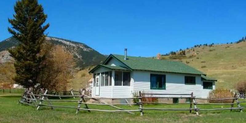
Within Custer National Forest, this US Forest Service cabin provides equestrian-focused accommodations with electricity and running water at $90 per night. The facility sleeps six and includes corrals, pasture access, and connects directly to forest service trails in multiple directions. Recent campers note the beds offer comfort and the cabin stocks dishware plus cleaning supplies.
Access requires navigating a rough road that challenges vehicles over 30 feet. Horse owners should bring extended hoses since the water hydrant sits approximately 115 feet from the corrals. The site prohibits pets and operates on a reservation-only basis with no tent camping allowed. For additional accommodation options, explore campgrounds near Custer National Forest.
Description
Overview
Meyers Creek Cabin is located within the Meyers Creek Work Center in Custer National Forest at an altitude of 5,646 feet. The cabin offers opportunities to enjoy relaxation and recreation in beautiful surroundings. It is reservable from May through November. The cabin is accessible by vehicle. 4-wheel drive is recommended during wet weather.
Recreation
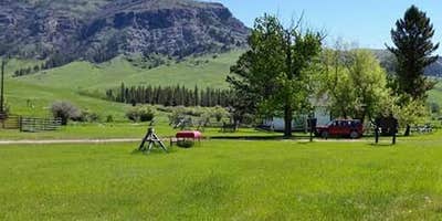
Trails crisscross the area, including the Meyers Creek and Lodgepole Creek Trails. This area offers recreation for hikers, mountain bikers and equestrians. Horse facilities are available at the cabin. Anglers can fish for rainbow and brown trout in nearby creeks.
Facilities
This cabin sleeps 6 people and comes equipped with 3 single mattresses and one double, an electric refrigerator, cook stove, heat, indoor toilet and shower, cookware, dishes and utensils. A campfire ring and picnic table are located outside. There is one corral, a watering tank and hitching rails for horses. Potable water is available, but guests may wish to bring a water filter or provide their own water if they are concerned about quality or taste. Items such as bedding, towels, washcloths and dish soap are not provided.
Natural Features
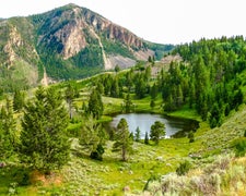
The cabin is situated in the western end of the Beartooth Mountains and surrounded by pastures, which are used for grazing cattle. Roses, irises, rhubarb and lilacs grow around the dwelling. The surrounding slopes are covered in pine, aspen and sagebrush, with wildflowers blooming in the summer. This area supports a large bear population ( bear safety ). Bighorn sheep, elk, deer and a variety of bird species also inhabit the mountainous terrain in the Beartooth Ranger District.
Nearby Attractions
The Stillwater River Trailhead, with access to the Absaroka/Beartooth Wilderness, is 16 miles south of the cabin.
RV Road Trip Guides

Map & DirectionsMeyers Creek Cabin is located in Montana near Nye
Directions
From the north, take State Highway 78 through Absarokee, Montana, to junction with State Highway 419 3 miles south of Absarokee. Turn right (west) and follow State Highway 419 for 21 miles to Nye. Turn right (north), following the directional sign for 1 mile. Turn left (west) at \"Y\" intersection and travel approximately 5 miles. Turn right (north) at Meyers Creek/Picket Pin Road intersection and follow road for 2 miles, turning left into Meyers Creek Work Center. From the south, take State Highway 78 from Red Lodge, Montana, to junction with State Highway 419 3 miles south of Absarokee. Turn right (west) and follow State Highway 419 for 21 miles to Nye, MT. Turn right (north), following the directional sign for 1 mile. Turn left (west) at \"Y\" intersection and travel approximately 5 miles. Turn right (north) at Meyers Creek/Picket Pin Road intersection and follow road for 2 miles. Turn left into Meyers Creek Work Center.
Address
BEARTOOTH RANGER DISTRICT
6811 HWY 212
Red lodge, MT 59068
Coordinates
45.4914198 N
109.9573458 W
Connectivity
 T-MobileLTESome Coverage
- VerizonLTESome Coverage
 AT&TNo Coverage
Connectivity
- T-MobileLTESome Coverage
- VerizonLTESome Coverage
- AT&TNo Coverage
Access
- Drive-InPark next to your site
- Walk-InPark in a lot, walk to your site.
- Hike-InBackcountry sites.
Site Types
- Cabins
- Equestrian
Features
For Campers
- Phone Service
- Reservable
- Drinking Water
- Electric Hookups
- Toilets
- Alcohol
Drive Time
- 2 hrs 30 min from Billings, MT
- 3 hrs 9 min from Bozeman, MT
- 4 hrs 32 min from Helena, MT
- 5 hrs 4 min from Great Falls, MT


