
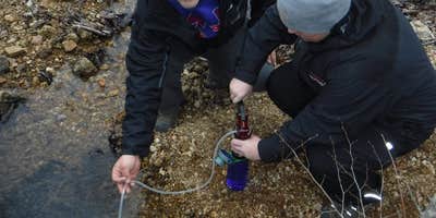
Within Mark Twain National Forest, Telleck Branch Primitive Campground provides hike-in access to backcountry camping along the Ozark Trail. Located three miles north of Big River, this free campsite sits at a creek crossing where multiple tent sites can accommodate 5-10 people. The creek supplies water that requires purification before drinking. Campers must follow Leave No Trace principles, including digging catholes at least 100 feet from water sources and camping 100 feet from the trail. The site serves hikers traveling the Ozark Trail corridor, though many continue south to Big River Primitive Campground for better positioning.
Description
Backcountry Primitive Campsite next to a water source with a fire ring. All garbage must be carried out
RV Road Trip Guides


Map & DirectionsTelleck Branch Primitive Campground is located in Missouri near Belleview
Coordinates
37.716035 N
90.952206 W
Connectivity
 T-MobileNo Coverage
 VerizonLTESome Coverage
- AT&TNo Coverage
Connectivity
- T-MobileNo Coverage
- VerizonLTESome Coverage
- AT&TNo Coverage
Access
- Hike-InBackcountry sites.
Site Types
- Tent Sites
Features
For Campers
- Pets
FREE established camping
Enjoy camping on government land. Limited or no services at this camping area.
PERMIT might be REQUIRED
We curate permit requirements across the US for our PRO members. Try PRO to see if Telleck Branch Primitive Campground needs a permit.
Drive Time
- 1 hr 42 min from St. Louis, MO
- 1 hr 45 min from Cape Girardeau, MO
- 2 hrs 11 min from Jefferson City, MO
- 2 hrs 41 min from Columbia, MO


