Public Campground
Springs Valley Rec Area
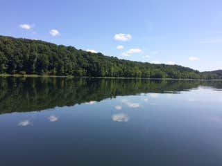
Springs Valley Rec Area near Paoli, IN, features a landscape of rolling hills and dense forests. Temperatures range from lows in the 20s during winter to highs in the 80s in summer. Nearby attractions include the Hoosier National Forest and Patoka Lake, offering opportunities for hiking and water activities.
Description
Due to safety concerns from recent flooding, the Hoosier National Forest’s Springs Valley Campground in Orange County is closed effective 05/11/2017. The vault restroom facilities and boat ramp at Springs Valley Recreation Area will remain open for public use. The 141-acre lake, once known as Tucker Lake, surrounded by scenic hardwood forests features primitive camping with vault toilets. No drinking water is available. A boat ramp and picnic facilities are also available. No fees are charged. Visitors to this area should be aware of a vandalism problem in this area and people are asked to report any suspicious activity or damage. For a downloadable flier with information and a map of this area click here.
Location
Springs Valley Rec Area is located in Indiana
Directions
From Hwy 37 south of Paoli turn right on Unionville Road, proceed for 1 mile, turn right at brown FS sign onto County Road 150 S. and proceed 1.1 miles to stop sign and turn left onto County Road 225 W, proceed 2.1 miles to brown FS sign and bear right on 325 S for 1.9 miles to stop sign, turn left on 500 W and go .8 miles to brown FS sign and turn Left on County Road 550 W. and follow this road back to Springs Valley Lake.
Coordinates
38.48500003 N
86.56400054 W
Connectivity
- T-MobileLTESome Coverage
- VerizonLTESome Coverage
- AT&T5GGood Coverage
Connectivity
- T-MobileLTESome Coverage
- VerizonLTESome Coverage
- AT&T5GGood Coverage
Access
- Hike-InBackcountry sites.
- Boat-InSites accessible by watercraft.
Site Types
- Tent Sites
Features
For Campers
- Picnic Table
- Phone Service
- Toilets
- Pets
- Fires
Drive Time
- 1 hr 7 min from Bloomington, IN
- 1 hr 14 min from Louisville, KY
- 1 hr 17 min from Owensboro, KY
- 1 hr 40 min from Columbus, IN


