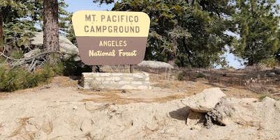
Within Angeles National Forest, Mount Pacifico Campground operates as a US Forest Service site accessible from May through November. The campground requires high-clearance vehicles when the access road opens during summer months, though many campers opt to hike in year-round. Sites sit on open terrain with fire rings and picnic tables scattered across multiple spots.
Reviewers consistently note the 360-degree views from the elevated location. The campground connects to the Pacific Crest Trail, with one camper describing a seven-mile northbound hike from Mill Creek Fire Station. For those exploring the broader region, pet-friendly camping spots around Angeles National Forest provide additional options since pets are welcome here. Cell service reaches the site, and both campfires and alcohol are permitted.
Description
Located near the western boundary of the San Gabriel Mountains National Monument, both road 3N17 and the access road to Mt. Pacifico Campground are open to street legal and off-highway vehicles, while road 3N90 (aka “Roundtop Road”) is only open to street-legal vehicles. Campsites are first-come-first-served. Interagency Pass or Adventure Pass required for vehicles parked at this campground. The Pacific Crest Trail passes 1/2 mile north downslope of the campground. Not RV accessible. 7100' elevation. 10 tent-only sites.
Warning 1 Alert is In Effect
There is 1 alert for this campground. Camp safely!
Warning 1 Alert is In Effect
There is 1 alert for this campground. Camp safely!
Air Quality at this campground may currently be unhealthy for sensitive groups.
RV Road Trip Guides

Map & DirectionsMount Pacifico Campground is located in California near Juniper Hills
Directions
From Interstate 210 in Pasadena, exit onto the Angeles Crest Highway (Hwy.2) and drive north for 9 miles. Turn left onto the Angeles Forest Hwy. (County Rd. N3) and drive about 12 miles to the intersection with Santa Clara Divide Rd. at Mill Creek Summit (there is a sign). Turn right and drive about 6 miles to the signed gate. Turn left and take the dirt road for 4 miles to the campground. The gate is locked in the winter when the road is impassable. Walk in at that time. May also be reached from the Sunland area by taking Big Tujunga Canyon Rd. and turning left at the Angeles Forest Highway, or by taking the Angeles Forest Highway from the Palmdale area.
Coordinates
34.38300038 N
118.03400075 W
Connectivity
 T-Mobile5GGood Coverage
 VerizonLTESome Coverage
 AT&T5GExcellent Coverage
Connectivity
- T-Mobile5GGood Coverage
- VerizonLTESome Coverage
- AT&T5GExcellent Coverage
Access
- Drive-InPark next to your site
- Walk-InPark in a lot, walk to your site.
- Hike-InBackcountry sites.
Site Types
- Tent Sites
- Group
- Equestrian
Features
For Campers
- Picnic Table
- Phone Service
- Toilets
- Alcohol
- Pets
- Fires
Drive Time
- 1 hr 34 min from Los Angeles, CA
- 2 hrs 8 min from Oxnard, CA
- 2 hrs 16 min from Bakersfield, CA
- 3 hrs 14 min from San Diego, CA


