Best Dispersed Camping near Heber Springs, AR

Dispersed camping opportunities around Heber Springs, Arkansas are primarily found in the Ozark National Forest, where several primitive sites offer free camping with minimal amenities. The Brock Creek area contains multiple dispersed camping locations, including Charleston Road sites, Brock Creek Lake View, and Brock Creek-Charleston Road dispersed areas. Tackett Mountain Road also provides free dispersed camping zones within the national forest. Camp Robinson Dispersed Site and Henry Gray Hurricane Lake Wildlife Management Area represent additional options for primitive camping on public lands in the broader region.

Access to most dispersed sites requires travel on gravel forest roads such as Charleston Road, which is generally well-maintained but may present challenges during wet conditions. Many campsites feature dirt surfaces with varying degrees of levelness and embedded rocks that might require careful positioning of vehicles. Higher clearance vehicles are recommended for reaching certain areas, especially after rain. Most sites accommodate tent camping and smaller vehicles like truck campers or campervans, though space is typically limited to 1-3 vehicles per site. No hookups, drinking water, toilets, or other amenities are available at these primitive locations.

The dispersed camping experience in this region includes wooded settings with occasional lake views, particularly at Brock Creek Lake sites when water levels are normal. Many areas are situated near OHV and multi-use trails, making them convenient bases for outdoor recreation. Fire rings are common at established dispersed sites, though campers should verify current fire restrictions. According to one visitor, "The site is set back from Charleston Road, offering a nice view" of Brock Creek Lake, though they noted it was drained during their visit. Another camper described Tackett Mountain Road dispersed site as "a nice place to simply hang out in" despite limited nearby hiking options. Cell service varies considerably throughout these remote forest areas.

Best Dispersed Sites Near Heber Springs, Arkansas (8)

Show More
Showing results 1-8 of 8 campgrounds

2025 Detourist Giveaway

Presented byToyota Trucks

Review Campgrounds. Win Prizes.

Enter to Win


Recent Free Dispersed Camping Photos near Heber Springs, AR

3 Photos of 8 Heber Springs Campgrounds


Dispersed Camping Reviews near Heber Springs, AR

12 Reviews of 8 Heber Springs Campgrounds


  • Fred S.The Dyrt PRO User
    Jul. 7, 2024

    Brock Creek - Charleston Rd Dispersed, Ozark NF, AR

    Nice Dispersed Site Above Brock Creek

    Not sure if the location pin is correct, so here are the coordinates: 35.49995, -92.80930. A large, wooded dispersed site situated above Brock Creek off of Charleston Road in a popular national forest OHV and multi-use trail area. Charleston Road is a wide, well maintained gravel road. The dispersed site can accommodate 2 or 3 vehicles - campervan size and smaller. There are 2 access driveways into the site. Access for a truck camper is tight due to the location of trees on the site. Access for 2WD low clearance vehicles may be rough due to some erosion. The dispersed site is a dirt surface with some embedded rocks jutting out. Some leveling may be required depending where the rig is parked. Tent camping is possible. There is a vehicle turnaround at the rear of the site. The site is shaded, so solar charging is limited. Except for a little bit of glass and some bullet shell casings scattered about, the site was clean at the time of my visit. The site has a large rock fire ring. There is a wide track that leads off the site toward the south along and above the creek. This track does not appears on any of the current forest service maps (including MVUM) that I have, so I'm assuming that it is not a legal motorized vehicle track. The track is hikeable. The site is convenient to OHV and multi-use trails. It was a pretty site during my summertime visit, but I bet it's beautiful during the Fall season. It is set back from Charleston Road. It is a really nice spot.

  • Fred S.The Dyrt PRO User
    Jul. 6, 2024

    Group Dispersed, Charleston Road, Ozark NF, AR

    Large Group Dispersed Camping

    Coordinates: 35.50873, -92.81549. Group dispersed site located less than a 1/4-mile south of the Zing Trailhead on Charleston Road. Charleston Road is a wide, well maintained gravel road located in a popular national forest OHV area. This dispersed site is a level with a dirt and grass surface. The site can accomodate multiple vehicles; tent camping is possible. There is a large rock fire ring at the rear of the site. The site is open with little shade, making recharging with solar panels possible. Other than accommodating a group of OHV and offroad enthusiasts, and stargazing at night, there is nothing remarkable about this campsite.

  • Fred S.The Dyrt PRO User
    Jul. 4, 2024

    Charleston Road Dispersed, Ozark NF, AR

    Convenient to National Forest OHV Area

    Pin location may not be correct, so here are the coordinates: 35.52534, -92.83158. Located on Charleston Road in a popular national forest OHV area - 1/2 mile southeast of the Mountain Man Trailhead. Charleston Road is a well maintained gravel road. The site is at the beginning of an old unnamed, closed, dirt track - close to Charleston Road. The site has a dirt surface; not quite level, but more level toward the rear. It is a pull-in site which can accommodate one campervan and smaller. Tent camping is possible. The site is mostly shaded. There is poison ivy around the perimeter of the site. The site includes a large rock fire ring. Except for a little bit of trash in the fire ring, the site was pretty much clean. The old track is gated just past the site,; the track is hikeable, leading up to the northern-most Stoebuck Mountain (there are two "Stoebuck Mountains" in this area). Except for being convenient to OHV trails, there is nothing remarkable about this dispersed site. It is good for an overnight stay.

  • Fred S.The Dyrt PRO User
    Jul. 2, 2024

    Austin Trailhead Dispersed, Wilderness Trail Rd, Ozark NF, AR

    Dispersed camping convenient to OHV/multi-use national forest trails

    Not sure if the pin location is correct, so here are the exact coordinates: 35.53654, -92.80322.  Small dispersed campsite just off Wilderness Trail Road. Wilderness Trail Road is a wide gravel country road located in a popular national forest OHV area. More specifically, the site is located on multi-use/OHV trail Brock Creek #42, Forest Road 2321 - just a few hundred feet south of Wilderness Trail (not in the trailhead parking lot, where camping is not allowed). Its a small, level dirt site, mostly shaded in a small clearing in the trees, close to the track - not private. It has a small rock fire ring. Tent camping is possible. It's a pull-in site which can accommodate one vehicle - truck camper and smaller. Except for being convenient to OHV trails, there is nothing remarkable about this dispersed site.

  • Fred S.The Dyrt PRO User
    Jul. 9, 2024

    Brock Creek Lake View Dispersed, Ozark NF, AR

    Lake View Dispersed Camping

    Coordinates: 35.49123, -92.80548. Large open dispersed site set back from Charleston Road, just north of Bell Rd (Forest Road 1334). Located in a popular national forest OHV and multi-use trails area. Charleston Road is a wide, well-maintained gravel road. Access to the site from Charleston Road is on a 400 foot long narrow dirt track; pinstripping is possible. The dispersed site has a dirt surface with some embedded rocks. It's on a rise above the lake, offering a nice view. Solar recharging is possible in this open site. The site is on what appears to be a parking area along an old dirt track; this track appears as an older section of Charleston Rd on some maps. There is a dirt ramp into the lake. There is room for multiple rigs at the campsite. Some leveling may be required depending on the spot the vehicle is parked. There are two rock fire rings - one large and one small. Tent Camping is possible near the fire rings. The lake was drained at the time of my visit; otherwise, it's a really nice view.

  • Fred S.The Dyrt PRO User
    Jul. 10, 2024

    Tackett Mountain Road Dispersed, Ozark NF, AR

    Nice site to hang-out in

    The pin location may not be accurate, so here are the coordinates: 35.44497, -92.76914. This is a small dispersed campsite with a level dirt surface, just big enough to accommodate one vehicle - truck camper and smaller. Tent and hammock camping is possible. The site is tucked into the trees, and it has a clean rock fire ring. The site is located on a dirt track - Forest Road 93021L, which is off of Tackett Mountain Road - Forest Road 1319. The site offers privacy from Tackett Mountain Rd, but it is close to Forest Road 93021L. Tackett Mountain Rd is a wide, well maintained, gravel forest road. Access to 93021L off of Tackett Mountain Road is up a slight incline with some gravel cover. Once up the incline, the track becomes dirt, goes through a clearing and heads into the woods where the dispersed site is located on the right. One can camp in the clearing; there is a small rock fire ring that is overgrown with grass and weeds, but the site in this review is nicer. The clearing was logged long ago where one may find some pieces of firewood. Some solar charging may be possible depending on the time of day and if the solar panels can be set up along the track in front of the site. There are no hiking trails here, although one can take a stroll along FR90231L which is less than a half-mile long. Even though there is not much to do around here, it's a nice place to simply hang out in. I liked it.

  • kThe Dyrt PRO User
    Jun. 18, 2024

    Camp Robinson Dispersed Site

    Free camp in the trees by drained part of lake

    Thank goodness there is a slight breeze. 90 degrees. Summer swampy area. Picked up a med bag of trash; cans, bottles, and paper. Looks better now. I definitely put on bug spray right away. Nice place to sleep and get back on 40East in the morning. Doing a cross country from San Francisco to Pennsylvania.

  • Steve R.The Dyrt PRO User
    Apr. 12, 2025

    Henry Gray Hurricane Lake Wildlife Management Area

    Can be wet. REQUIRES PERMIT

    It had rained and the road in was near a foot deep flowing water. Not a problem on our motorcycle but a car may have issues with water coming in. This was a, nice Campground BUT it does require a hunting/fishing permit and we were given a written warning. Apparently this is true of all Arkansas public property despite app saying otherwise.

  • Alice S.The Dyrt PRO User
    Oct. 11, 2024

    Henry Gray Hurricane Lake Wildlife Management Area

    Mosquito Alley

    The site itself isn't bad. It is very well shaded with 8-10 concrete pads. There are a few concrete benches and a water spigot. There is a huge parking lot next to it for trucks with boats/trailers to park.

    This site is normally used for hunting and fishing. There is a shooting range on the road before you get to the site.

    I'm here I October and there are still quite a few mosquitoes. I imagine in the warmer months they would be unbearable. Also the cell signal is pretty spotty.

    Overall, nice for a free spot but not the greatest.


Guide to Heber Springs

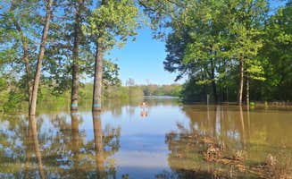
Dispersed camping options near Heber Springs, Arkansas extend throughout the Ozark National Forest with seasonal variations affecting accessibility and amenities. Located at elevations ranging from 500-2,000 feet, these primitive sites experience average summer temperatures around 90°F and winter lows near 30°F. Rain can create challenging conditions on forest access roads from November through April, when water levels at sites like Brock Creek fluctuate considerably.

What to do

Wildlife viewing opportunities: The Henry Gray Hurricane Lake Wildlife Management Area features abundant bird watching opportunities in its wetland environment. "There is a shooting range on the road before you get to the site," notes reviewer Alice S., making it convenient for hunters preparing for seasonal activities.

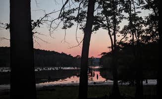
Stargazing sessions: The Group Dispersed site on Charleston Road offers excellent night sky viewing due to minimal light pollution. According to Fred S., the area is "open with little shade, making recharging with solar panels possible" and ideal for "stargazing at night" away from urban light sources.

Short hikes: Several closed forest tracks near dispersed sites offer walking opportunities without established trails. At Charleston Road Dispersed, a camper notes "the old track is gated just past the site; the track is hikeable, leading up to the northern-most Stoebuck Mountain" providing a natural option for stretching your legs.

What campers like

Privacy between sites: At Brock Creek - Charleston Rd Dispersed, campers appreciate the secluded setting. One reviewer states it "is set back from Charleston Road" and "is a really nice spot" with good separation from neighboring areas.

Accessibility for small vehicles: Most sites accommodate modest-sized camping setups. At Camp Robinson Dispersed Site, Rylie R. found it "a great spot to pitch a tent by lake Conway. Isolated but not too far out," making it suitable for those without specialized off-road vehicles.

Natural sounds: The ambient noise of local wildlife enhances the camping experience. One visitor to Camp Robinson noted, "The birds and frogs sang all evening," creating a peaceful soundscape typical of the region's dispersed sites.

What you should know

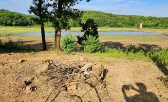
Seasonal maintenance affects water features: Water levels at lakes near camping areas fluctuate due to management practices. Julie A. reports at Camp Robinson that "the lake has been partially drained to allow work to be done on stumps," a common occurrence affecting lake views at various sites.

Permit requirements: Despite listings indicating free camping, some locations have specific permit needs. At Henry Gray Hurricane Lake Wildlife Management Area, Steve R. warns, "This was a nice Campground BUT it does require a hunting/fishing permit and we were given a written warning. Apparently this is true of all Arkansas public property despite app saying otherwise."

Variable cell coverage: Mobile phone reception differs significantly across sites. At Camp Robinson, Julie A. reported "we had good cell reception with AT&T and Spectrum," though service quality varies considerably throughout the Ozark National Forest region.

Tips for camping with families

Safety planning: Prepare for unexpected nighttime disturbances at some locations. At Camp Robinson Dispersed Site, Mason G. experienced disruptions: "I woke up at 11pm to someone driving in then 12:30am then at 1:30 a loud truck came in slinging rocks and a guy was screaming out the window. So I was packed up and was out by 2am."

Insect management: Summer months bring significant insect activity, particularly in lowland areas. One camper at Henry Gray Hurricane Lake noted, "I'm here in October and there are still quite a few mosquitoes. I imagine in the warmer months they would be unbearable."

Trash cleanup: Teaching children about wilderness stewardship provides an educational component. Ken H. at Camp Robinson shared, "Picked up a med bag of trash; cans, bottles, and paper. Looks better now," demonstrating how visitors can improve the camping experience.

Tips from RVers

Site selection for small rigs: The Tackett Mountain Road Dispersed site works well for compact camping vehicles. Fred S. describes it as "a small dispersed campsite with a level dirt surface, just big enough to accommodate one vehicle - truck camper and smaller."

Water crossing assessment: After rain, evaluate road conditions carefully. At Henry Gray Hurricane Lake, Steve R. encountered challenging water levels: "It had rained and the road in was near a foot deep flowing water. Not a problem on our motorcycle but a car may have issues with water coming in."

Surface considerations: Many sites have uneven terrain with natural obstacles. At Brock Creek - Charleston Rd, a reviewer noted the "dispersed site is a dirt surface with some embedded rocks jutting out. Some leveling may be required depending where the rig is parked," suggesting campers bring leveling blocks.

Frequently Asked Questions

Which is the most popular dispersed campsite near Heber Springs, AR?

According to TheDyrt.com, the most popular dispersed campground near Heber Springs, AR is Camp Robinson Dispersed Site with a 3.8-star rating from 4 reviews.

What is the best site to find dispersed camping near Heber Springs, AR?

TheDyrt.com has all 8 dispersed camping locations near Heber Springs, AR, with real photos and reviews from campers.