Fishing and swimming opportunities draw campers to Arlie Moore - De Gray Lake, a US Army Corps of Engineers campground on the north shore of DeGray Lake. The facility accommodates RVs up to 60 feet with electric and water hookups, plus tent camping options that range from forested sites to spots directly on the water. Access comes via I-30, making the location relatively convenient for travelers.
Sites include picnic tables, fire rings, and lantern posts, with some positioned close enough to the lake that campers can swim within 20 feet of their tent. The campground maintains restrooms with showers, though reviews note bathroom conditions vary. A boat launch serves anglers and recreational boaters, while a designated swim beach provides lake access. "Water is warm and I swim less than 20 feet from my tent," reports Gary M..
Several campers mention hearing coyotes at night, and the area includes a 1.3-mile hiking trail, though it sees limited use. Site leveling can be challenging, with some spots described as steep. The campground operates year-round at $24 per night, with reservations available through the Corps of Engineers system. Campers exploring the broader region can find campsites near DeGray Lake for additional options.
Description
Overview
Arlie Moore Campground sits on the northern banks of DeGray Lake in the foothills of the Quachita Mountains. Hikers find Arlie Moore particularly inviting. In past years, the National Recreation Reservation Service selected the Arlie Moore Interpretive Trail as one of America's Top 25 Hiking Trails.
Recreation
Boating, water skiing, kayaking and other water sports are the biggest draw to the lake, and a boat ramp and swimming beach are provided. The lake is also stocked with a variety of game fish, including plenty of hybrid striped bass, making it an ideal area for both boat and bank fishing. Numerous hiking and bike riding trails wind around the lake shore, including the Arlie Moore Interpretive Trail.
Facilities
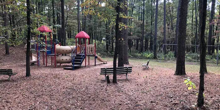
All campsites come with electric hookups. The park also has a swimming beach, amphitheater, playground, flush toilets and hot showers. To see USACE DeGray Lake Virtual Tour, click here.
Natural Features
Degray Lake is one of the region's five Diamond Lakes, known for their crystal clear waters. The lake flows from the Caddo River in western Arkansas and spans 13,500 surface acres.
Nearby Attractions
The DeGray Lake Resort State Park offers golf courses, tennis courts, horseback riding trails and more along the 207 miles of lake shoreline. The Ouachita National Forest and Hot Springs National Park are both located nearby.
RV Road Trip Guides


Map & DirectionsArlie Moore is located in Arkansas near Bismarck
Directions
From Interstate 30, take exit 78 and merge onto State Highway 7 north for 9 miles. Turn left onto Arlie Moore Road and continue 2 miles to campground.
Address
729 CHANNEL ROAD
Arkadelphia, AR 71923-9364
Coordinates
34.2716667 N
93.2041667 W
Connectivity
 T-MobileNo CoverageVerified by 3 users
 VerizonLTESome CoverageVerified by 1 user
- AT&TLTESome Coverage
Connectivity
- T-MobileNo CoverageVerified by 3 users
- VerizonLTESome CoverageVerified by 1 user
- AT&TLTESome Coverage
Access
- Drive-InPark next to your site
- Walk-InPark in a lot, walk to your site.
- Boat-InSites accessible by watercraft.
Site Types
- Tent Sites
- RV Sites
- Standard (Tent/RV)
- Group
- Cabins
Features
For Campers
- Trash
- Picnic Table
- Phone Service
- Reservable
- Drinking Water
- Electric Hookups
- Toilets
- Alcohol
- Pets
- Fires
For Vehicles
- Sanitary Dump
- Water Hookups
- 50 Amp Hookups
Drive Time
- 30 min from Hot Springs, AR
- 1 hr 6 min from Little Rock, AR
- 1 hr 22 min from Texarkana, TX
- 2 hrs 43 min from Fort Smith, AR


