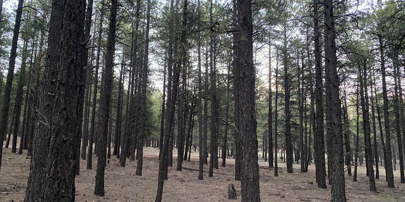
This free dispersed camping area sits along Forest Road 222, accessible via a gravel road that turns rough near the entrance but remains manageable for RVs up to 36 feet with careful driving. Campers find numerous sites scattered throughout the forested terrain, with options ranging from roadside spots to more secluded locations deeper into the area.
The forest setting provides natural screening between sites, though the experience varies significantly by location. A nearby shooting range generates consistent gunfire that can last from morning until 11 PM, particularly affecting sites on the left fork of the road. Campers seeking quieter conditions report better success camping near the entrance or taking the right fork when the road splits. Weekend traffic includes dirt bikes and ATVs, with most riders staying respectful of speed limits on the main access road.
Cell service reaches most areas, making this a practical base for exploring the region. The terrain offers hiking opportunities, including trails that lead to meadow views. Monte W. notes the area near "the old Wing mountain recreational area" as particularly appealing. Fire restrictions apply during dry conditions, though propane fire rings remain permitted.
Trash cleanup remains an ongoing issue despite pack-in, pack-out policies. Campers should come prepared for dispersed camping around Coconino National Forest with their own water and waste disposal plans.
Description
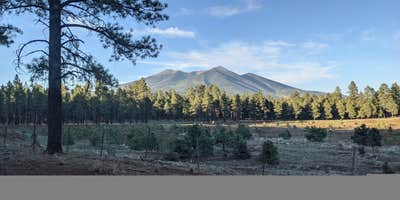
Looking for a camping spot in the woods with easy access to some of the Flagstaff area's fantastic trails and recreation opportunities along US 180? The Wing Mountain area southwest of the San Francisco Peaks offers fantastic dispersed camping along Forest Roads (FRs) 222__and 171, suitable for tents, campers, and recreational vehicles.Wing Mountain is a prominent cinder cone volcano located approximately six miles southwest of the San Francisco Peaks, rising to an elevation of 8,560 feet. The mountain is surrounded by ponderosa pine forest on fairly level terrain at approximately__7,600 feet.__FR__222__and FR 171: Easy to navigate, with fairly smooth, wide dirt roads offering areas where you may pull your vehicle and rig up to 300 feet off the road (refered to as "camping corridors" on the Motor Vehicle Use Map).Western end__of FR 222A (between FR 171 and FR 519): Easy to navigate and offers areas suitable for everything from tents to recreational vehicles.Northern end of FR 222A (near FR 222) and western end of FR 9001P (near FR 171): These roads are narrower and rougher, and more suited to tent or small trailer camping.__Nearby Attractions and ActivitiesDistances and estimated driving times from the junction of US 180 and Forest Road 222:Arizona Snowbowl: 8 miles, 16 minutesHumphreys, Aspen Loop, and Kachina trailheads (at the Snowbowl): 8 miles, 16 minutesKendrick Park Watchable Wildlife Trail: 11.5 miles, 13 minutesBismarck Lake Trail: 13.5 miles, 22 minutesArizona Nordic Village: 7.8 miles, 10 minutesRed Mountain Trail: 23 miles, 27 minutesSlate Mountain Trail: 24 miles, 40 minutesLava River Cave: 10.5 miles, 20 (via FR 245)__to 30 minutes (via FR 222)__Hover mouse cursor over image to display slideshow controls.View album on Flicker__
RV Road Trip Guides


Map & DirectionsWing Mountain Dispersed Camping is located in Arizona near Bellemont
Directions
Flagstaff to Forest Road 222 via US 180 (map):__Drive north on US 180 for 8.7 miles. Turn left on FR 222 (1.3 miles past Snowbowl Road). The dispersed camping area begins here and extends most of FR 222 (6.5 miles), and along FR 171 between FR 222 and FR 222A (to the south).Flagstaff to Forest Road 171 via I-40 (map): Drive east on I-40 for 10 miles from the I-17/I-40 interchange. Take exit 185 toward Belmont. Turn right onto Transwestern Road, then left on Brannigan Park Road. Drive for 0.8 miles and turn right onto Forest Road 171. Drive 1.1__mile to the southern end of the dispersed camping area at the junction of FR 171 and FR 222A. The dispersed camping area extends up FR 171 for two miles to FR 222, and most of the lenghth of FR 222.There are also additional dispersed camping corridors along FR 171 north of FR 222 in the Lava River Cave area.__Click on map thumbnail to open a larger view in a new window__[PDF, 4.2 MB]:__
Coordinates
35.269523 N
111.742766 W
Connectivity
 T-Mobile5GExcellent CoverageVerified by 8 usersLast on 8/1/26
- Verizon5GExcellent CoverageVerified by 14 usersLast on 8/1/26
 AT&TLTESome CoverageVerified by 10 usersLast on 8/1/26
Connectivity
- T-Mobile5GExcellent CoverageVerified by 8 usersLast on 8/1/26
- Verizon5GExcellent CoverageVerified by 14 usersLast on 8/1/26
- AT&TLTESome CoverageVerified by 10 usersLast on 8/1/26
Access
- Drive-InPark next to your site
- Walk-InPark in a lot, walk to your site.
Site Types
- Tent Sites
- RV Sites
- Dispersed
Features
For Campers
- Phone Service
- Alcohol
DISPERSED CAMPING
Enjoy dispersed camping on government land and leave no trace. Pack in and pack out. No (or limited) services at this camping area. Permit may be required.
PERMIT might be REQUIRED
We curate permit requirements across the US for our PRO members. Try PRO to see if Wing Mountain Dispersed Camping needs a permit.
Drive Time
- 15 min from Flagstaff, AZ
- 1 hr 26 min from Prescott Valley, AZ
- 2 hrs from Phoenix, AZ
- 3 hrs 12 min from Lake Havasu City, AZ


