Campground photo 1
Campground photo 2
Campground photo 3

Places to Camp near Ojo Caliente, NM

Searching for the best camping near Ojo Caliente, NM? There are tons of hikes and other fun activities to partake in. Experience some of the most stunning views that New Mexico camping has to offer. You're sure to find the perfect spot for your New Mexico camping adventure.

Best Camping Sites Near Ojo Caliente, NM (214)

  1. Camper-submitted photo from Taos Valley RV Park & Campground
  2. Camper-submitted photo from Ojo Caliente Mineral Springs Resort & Spa

    2.

    Ojo Caliente Mineral Springs Resort & Spa

    10 Reviews
    57 Photos
    93 Saves
    Ojo Caliente, New Mexico
    • Pets
    • Fires
    • Electric Hookups
    • Phone Service
    • Reservable
    • ADA Access

    $40 - $60 / night

  3. Camper-submitted photo from Riana - Abiquiu Lake

    3.

    Riana - Abiquiu Lake

    17 Reviews
    86 Photos
    166 Saves
    Cañones, New Mexico

    Overview

    Riana Campground is located on a 150 ft. bluff overlooking the scenic Abiquiu Lake in northern New Mexico, just one hour northwest of charming Santa Fe. The lake sits at an elevation of 6,400 feet on the Rio Chama, a tributary of the legendary Rio Grande.

    Recreation

    Abiquiu Lake offers many opportunities for outdoor recreation. The fishing here is some of the finest in northern New Mexico. Visitors enjoy boating, water skiing, and hiking. Lake shore access for boat launching is 1 mile from the campground.

    Facilities

    Riana Campground hosts 52 campsites, 13 of which have electric and water hookups. Flush toilets, showers, and drinking water are provided, as are picnic shelters, grills, lantern posts, and tent pads. A playground and dump station are located on-site.

    Natural Features

    Fragrant Pinion pine, juniper, and sage cover the campsite, providing a distinct smell of northern New Mexico, but offering limited shade. Colorful rock formations surround the park. Visitors are awarded a panoramic view of the narrow mesa, Cerro Pedernal, locally known as "Pedernal." Famous American painter, Georgia O'Keefe, had her ashes scattered over its top.

    contact_info

    For facility specific information, please call (505) 685-4561.

    Nearby Attractions

    Northern New Mexico is full of beauty and history. The educational and historical Ghost Ranch is about 10 minutes from the park. The Georgia O'Keeffe Museum, San Pedro Wilderness, Cumbres Toltec Railroad, Chaco Canyon, and Bandelier National Monument are all nearby. The ski-town of Taos is just over an hour away, and colorful Santa Fe is an hour southeast, both with restaurants, shops, and museums.

    • Pets
    • Fires
    • Electric Hookups
    • Phone Service
    • RVs
    • Tents

    $20 / night

  4. Camper-submitted photo from BLM Orilla Verde Recreation Area

    4.

    BLM Orilla Verde Recreation Area

    8 Reviews
    10 Photos
    279 Saves
    Carson, New Mexico

    The Orilla Verde Recreation Area is located within the Rio Grande Del Norte National Monument and along the Rio Grande Wild and Scenic River. Nestled along the banks of the Rio Grande and within the steep-walled Rio Grande Gorge, the campgrounds in this area offer nearby access to the river. The elevation along the river is 6,100 feet and the steep canyon rises 800 feet from the river to the Gorge rim.

    Because of the dramatic changes in elevation and the diversity of plant life, Orilla Verde draws many species of animals, including raptors (such as eagles and hawks), songbirds, waterfowl, beaver, cougar, ringtail, mule deer, and more. The Rio Grande also has attracted humans since prehistoric times. Evidence of ancient peoples is found throughout the Recreation Area in the form of petroglyphs on the rocks and many other types of archaeological sites.

    The climate at Orilla Verde is semi-arid, with summer thunderstorms common in July and August, and snow possible from October through March. Summer temperatures range from 45 to 90 degrees, and winter temperatures range from -15 to 45 degrees

    • Pets
    • Fires
    • Electric Hookups
    • Reservable
    • ADA Access
    • Dispersed

    $5 - $15 / night

  5. Camper-submitted photo from Black Canyon Campground

    5.

    Black Canyon Campground

    24 Reviews
    67 Photos
    439 Saves
    Tesuque, New Mexico

    Overview

    At 8475 feet in elevation, Black Canyon Campground is in a great location to experience some of the finest mountain scenery the Southwest has to offer. The facility is newly renovated and provides access to a variety of outdoor recreational activities. Campers can enjoy warm days and cool weather in the summer months, providing a scenic getaway from the desert heat.

    Recreation

    Hikers enjoy a pleasant hiking 1.5-mile trail that loops around the campground and into the surrounding forest. Several additional hiking, mountain biking and horseback riding trails are located nearby. The Pecos Wilderness can be accessed eight miles from the campground, with many trails leading to majestic peaks and through valleys, canyons and forested groves. Many recreation opportunities exist along Highway 475, both above and below Black Canyon Campground, including hiking and biking trails and picnic areas. In the winter, the area offers both Nordic and alpine skiing.

    Facilities

    The campground offers many single and double-family sites, most of which are accessible. Some sites are designated as walk-to sites for tent camping only. A few are available on a first-come, first-served basis.Each site is equipped with a table and campfire ring with grill. Accessible vault toilets are provided. The highway to the campground is paved. There is currently no water available on the campground, bring your own water.The campground is adjacent to New Mexico's Hyde State Park, where a dump station is available.

    Natural Features

    The campground is situated in a forest of pine, aspen and fir trees. A good mix of sun and shade is found throughout the area. Many beautiful views are found in the surrounding forest.

    contact_info

    This location has limited staffing. Please call (505) 753-7331 for general information.

    Nearby Attractions

    The campground is located about seven miles northeast of the town of Santa Fe, New Mexico. This unique town is known for its cultural heritage, art galleries and museums.

    • RVs
    • Tents
    • Group
    • Standard (Tent/RV)
    • Trash
    • Toilets

    $10 / night

  6. Camper-submitted photo from Juniper Family Campground — Bandelier National Monument

    6.

    Juniper Family Campground — Bandelier National Monument

    26 Reviews
    179 Photos
    297 Saves
    White Rock, New Mexico

    Overview

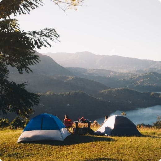
    Juniper Family Campground is the ideal place to camp on the Pajarito Plateau. Located just inside the main park entrance, the campground is a short drive from the Bandelier Visitor Center, the Frijoles Canyon Shuttle bus system (mid-May to mid-October), and the adjacent towns of Los Alamos and White Rock. Juniper Family Campground is the perfect "home base" to explore the Pajarito Plateau, Jemez Mountains, and all of north central New Mexico!____ Reservations. The campground is divided into 3 loops: Loop A campsites are available year-round as first-come, first serve only. Pay for first-come, first-serve campsites at the self-pay kiosk located at the Juniper Family Campground or in-person at the Bandelier Visitor Center during business hours.____ Loop B campsites are open year-round and are reservable up to 6 months in advance. Some sites may open on shorter booking windows (7 or 14 days in advance or the day of arrival).__ Loop C campsites are open seasonally, March 1 ___ October 31, and are reservable up to 6 months in advance. Some sites may open on shorter booking windows (7 or 14 days in advance).__ You may also book campsite reservations in loops B & C on the day of arrival (subject to availability). HOWEVER, cell service/data is not always reliable in the park and no public WiFi is available. The park highly recommends booking your reservation from the neighboring towns of Los Alamos and White Rock before heading to the park.____ Group campsites (in Loop A) are available by reservation only up to 12 months in advance until the day before arrival (subject to availability). Same day reservations are not available for group campsites.

    Recreation

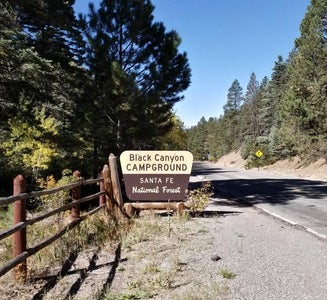
    Bandelier is home to over 70 miles (113 km) of hiking trails most of which are located within federally designated wilderness. Two trails are accessible directly from Juniper Family Campground. The Frey Trail follows the historic route into Frijoles Canyon and descends down the canyon wall to the Visitor Center and the Main Loop Trail. The Tyuonyi Overlook Trail leaves the amphitheater parking area for a 3/4-mile (1.2 km) hike across the open mesa top to an overlook providing breathtaking views of Frijoles Canyon and of Tyounyi, an ancestral Pueblo village. The Bandelier Visitor Center houses museum exhibits, park film, information and ranger programs, Western National Parks Association sales outlet, and more. Entrance to Frijoles Canyon and the Visitor Center is by shuttle bus only (or by hiking) from mid-May to mid-October. These areas are accesibile by private vehicle outside the shuttle bus period.______ Many other opportunities for recreation and exploring the history and culture of the area are nearby, such as Valles Caldera National Preserve, Manhattan Project National Historical Park, Los Alamos museums, the Jemez District of the Santa Fe National Forest, US Department of Energy public recreation trails, and others around Los Alamos County.____ Rock climbing is prohibited within Bandelier National Monument, however many popular climbs are within a short drive up Route 4 into the Jemez Mountains.

    Facilities

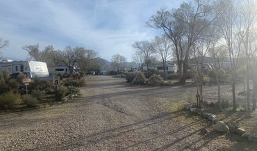
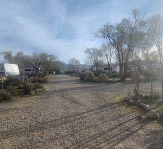
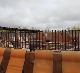
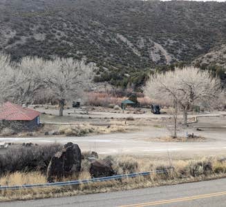
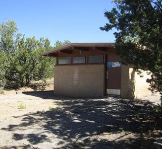
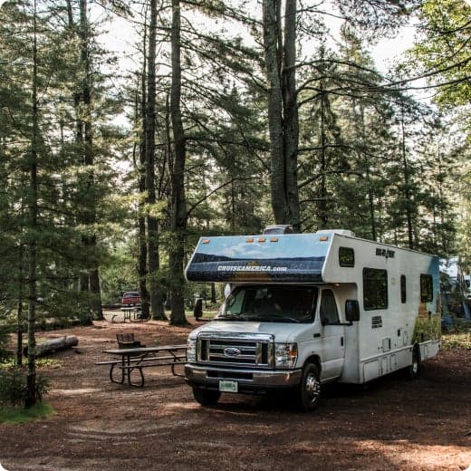
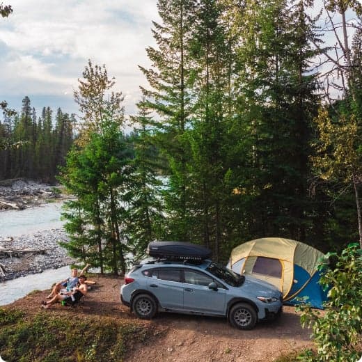
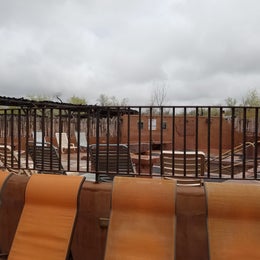
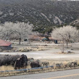
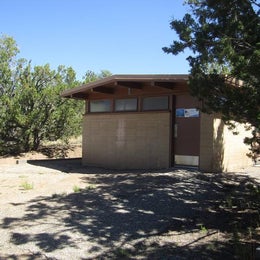
    Juniper Family Campground has 3 camping loops. There is an RV dump station on the road into the campground, however water at the dump station is completely turned off from mid-October to mid-April (campers will not be able to fill water tanks or dump). During the summer months, interpretive programs may be offered during the day at the Visitor Center and in the evening at the campground amphitheater (check with the Visitor Center for program schedule).______ Each loop offers its own comfort station with restrooms and running water and centrally located water spigots with potable water. No hookups are available at any campsites. Shade is limited in most campsites. During the summer months a camp host is present in the campground.____ Individual Campsites Each individual campsite has a paved parking pull in or pull through parking spot. Driveways/pull through size vary by site, many can accommodate larger RVs/trailers. Picnic tables, fire rings with grills, and food lockers are provided at each campsite. There are three camping loops with individual campsites: Group Campsites Group campsites Each group campsite is for tent camping only and has ample space for multiple tents. Only one (1) RV or trailer is permitted per site. Each site can accommodate 10 to 20 campers. Group campsites have picnic tables, fire rings with grills and food lockers.______ Transportation The Frijoles Canyon Shuttle system (mid-May to mid-October) includes a stop at the Amphitheater parking area located in the Juniper Family Campground. You may ride the shuttle free of charge with service into Frijoles Canyon with a stop at the Visitor Center. Private vehicle traffic into Frijoles Canyon is prohibited while the shuttle is in service.__

    Natural Features

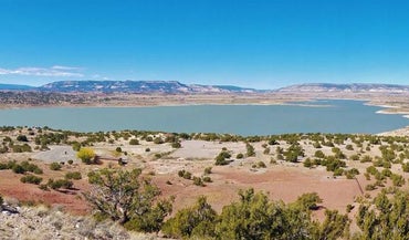
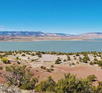
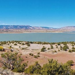
    Bandelier National Monument protects over 33,000 acres (13355 ha) of rugged, beautiful canyon and mesa country which features evidence of human presence going back over 11,000 years. Petroglyphs, dwellings carved into the soft rock cliffs, and standing masonry walls pay tribute to the early days of a culture that still survives in the surrounding communities.____ Bandelier National Monument sits at the southern end of the Pajarito (Spanish for little bird) Plateau. The plateau was formed by two eruptions 1.6 and 1.4 million years ago. Home to the Bandelier Wilderness, Bandelier ranges from 5340 ft (1628 m) at the Rio Grande River to the south and 10,199 ft (3109 m) at the summit of Cerro Grande to the north, almost a mile of elevation change in just under 12 miles (19 km). This elevation gradient creates a unique diversity of habitats specific to Northern New Mexico. The diversity of habitats and quick access to water supported a relatively large population of Ancestral Pueblo people. Currently, Pi__on-Juniper woodlands dominate in the southern parts of the park transitioning through ponderosa pine savannahs and forests, finally reaching mixed conifer forests at the highest elevation. Scattered throughout the park are desert grasslands, montane meadows, and riparian areas in the canyon bottoms. Over 70 miles (113 km) of trails at Bandelier climb in and out of deep canyons and cross large flat mesas, showcasing the entire spectrum of volcanic geology and ecosystems found within the park. The park is home to over 55 species of mammals including mule deer, Abert's squirrels, mountain lions, black bears, and 16 species of bats. Reptiles and amphibians of all shapes and sizes can be seen. Birds such as Steller's jays, canyon towhees and mountain chickadees stay year-round, whereas turkey vultures, western tanagers, and black-headed grosbeaks are summer residents.

    contact_info

    This location is unstaffed. To speak with our main office for general information, please call: (505) 672-3861.

    Nearby Attractions

    The town of Los Alamos has shopping, museums, amenities, a movie theater, ice rink, ski hill, and is home to Manhattan Project National Historic Site.____ Nearby Department of Energy and US Forest Service lands provide trails which accommodate pets.__ Valles Caldera National Preserve is 16 miles (26 km) west of Bandelier.____ Jemez Historic Site is 37 miles (60 km) west.__ Pecos National Historical Park is 70 miles (113 km) southeast.____ Santa Fe, 40 miles (64 km) south of the park, is home to the New Mexico state capitol, museums, historic districts, art galleries, food, accomodations, and more.__

    • Pets
    • Fires
    • Phone Service
    • RVs
    • Tents
    • Group

    $50 / night

  7. Camper-submitted photo from Hotel Luna Mystica

    7.

    Hotel Luna Mystica

    12 Reviews
    42 Photos
    201 Saves
    Arroyo Hondo, New Mexico

    Hotel Luna Mystica is a vintage trailer hotel and campground in Taos, NM. We are an independent property, located 15 minutes from downtown Taos, near the Gorge Bridge, Mamby Hot Springs and Earthship Biotecture. We are also next door to Taos Mesa Brewing, a full restaurant and venue. Our camp sites are primitive but we do have a free standing tiny house with 2 indoor bathrooms/showers, 2 outdoor showers, and a utility sink with great drinking water on the outside. We have WiFi which may help as cell service is spotty on the west side of Taos. Access to our brand new lounge! Sites are not marked, we prefer to let people find places that feel good to them. The area is safe. No creepy crawlies, just coyotes, bunnies, friendly dogs and a cat. There are fire pits and wood is available for purchase on site. Please respect neighbors, campground is mellow.

    • Pets
    • Fires
    • Phone Service
    • Reservable
    • ADA Access
    • RVs

    $25 / night

  8. Camper-submitted photo from Sante Fe National Forest BLM-Road 62 Dispersed
  9. Camper-submitted photo from Taos Junction Campground
  10. Camper-submitted photo from El Rito Campground

    10.

    El Rito Campground

    4 Reviews
    9 Photos
    31 Saves
    El Rito, New Mexico

    11 campsites at 7600' with excellent hiking and fishing access, this area is often crowded in summer

    • Pets
    • Fires
    • RVs
    • Tents
    • Standard (Tent/RV)
    • Toilets
Showing results 1-10 of 214 campgrounds

Popular Camping Styles near Ojo Caliente

Pet-friendly camping near Ojo Caliente

Recent Reviews In Ojo Caliente

800 Reviews of 214 Ojo Caliente Campgrounds