Part of Shoshone National Forest, Beartooth Plateau provides established camping under US Forest Service management in a high-elevation setting. The campground sits at significant altitude, requiring visitors to prepare for mountain conditions and potential weather changes.
Access involves forest roads that may present challenges for larger RVs or during adverse conditions. Campers should verify current road status before arrival, particularly early and late in the season when snow can affect accessibility. The location offers proximity to several other forest campgrounds, including Hunter Peak less than five miles away. Mountain terrain provides opportunities for hiking and exploring the surrounding national forest lands.
Description
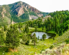
The Clarks Fork Ranger District encompasses much of the Beartooth Plateau, which is located in northwest Wyoming, near Yellowstone National Park. The Beartooth Plateau gets its name from Beartooth Peak, which has the appearance of a bear's tooth. The scenery here is breathtaking - rugged mountain peaks and expansive plateaus, alpine tundra, glaciers, wildlife, wildflowers, and rare land types found nowhere else in the United States. Travel the Beartooth All-American Road, U S Highway 212, to take in the views. (The road is closed in the winter.)
RV Road Trip Guides

Map & DirectionsBeartooth Plateau is located in Wyoming near Cooke City
Directions
The Beartooth Plateau is accessed by U S Highway 212 and State Highway 296. This road is closed in the winter. The nearest town is Cooke City, Montana.
Coordinates
44.84380035 N
109.5757 W
Connectivity
 T-MobileNo Coverage
- VerizonNo Coverage
- AT&TNo Coverage
Connectivity
- T-MobileNo Coverage
- VerizonNo Coverage
- AT&TNo Coverage
Access
Site Types
- Tent Sites
Features
Drive Time
- 2 hrs 10 min from Billings, MT
- 3 hrs 27 min from Bozeman, MT
- 4 hrs 50 min from Helena, MT
- 6 hrs 41 min from Idaho Falls, ID

