Hannegan Trailhead is located near rugged terrain with dense forests and mountain views. Temperatures can range from lows in the 30s Fahrenheit during spring and fall to highs in the 70s during summer. Nearby, visitors can explore the scenic Mount Baker Wilderness and Nooksack Falls.
Description
Provides access to: Hannegan Pass Trail 674 which accesses Mt. Baker Wilderness and North Cascades National Park.
RV Road Trip Guides
SPONSORED BY

Map & DirectionsHannegan Trailhead is located in Washington near Maple Falls
Directions
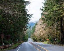
From Glacier, travel east on Mt. Baker Highway SR 542 to 12.5 miles east of the Glacier Public Service Center. Then turn left on Hannegan Pass Road #32. Follow Road #32 for 5.3 miles to the trailhead and parking at the end of the road.
Coordinates
48.91021099 N
121.59188528 W
Connectivity
 T-MobileNo Coverage
- VerizonNo Coverage
- AT&TNo Coverage
Connectivity
- T-MobileNo Coverage
- VerizonNo Coverage
- AT&TNo Coverage
Access
Site Types
- Tent Sites
Features
Drive Time
- 1 hr 16 min from Bellingham, WA
- 1 hr 38 min from Mount Vernon, WA
- 2 hrs 32 min from Seattle, WA
- 3 hrs 29 min from Bremerton, WA

