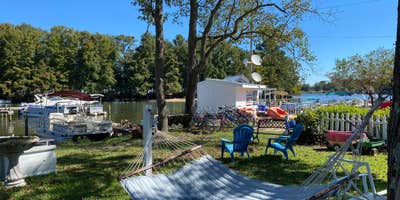
Lake Marion hosts Lakeside Marina & Resort, a private campground that combines marina services with camping options across multiple settings. The facility provides full hookups for RVs along the shoreline, plus tent camping on a small island accessible by canoe or kayak. Campers can reach sites by both boat and vehicle, with the marina lending watercraft to overnight guests.
The resort includes cabins directly on the water and maintains restrooms, showers, and WiFi for campers. Beyond the developed camping areas, the island offers primitive tent sites without utilities, requiring a short paddle from the main facility. Mill Creek Marina and Campground provides another lakefront option for visitors exploring different sections of Lake Marion.
Description
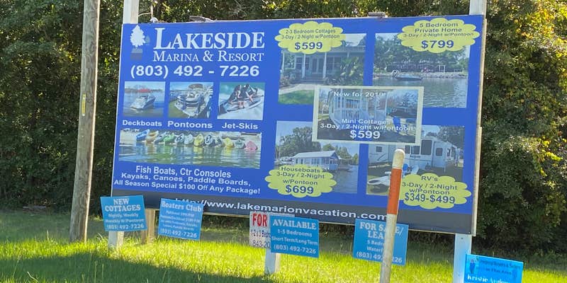
Your casual outdoor paradise awaits at Lakeside Marina & Resort, where a marina, waterfront lodging, boat rentals, fishing, award winning golf, outlet shopping, restaurants and much more are all right here within minutes of Santee, South Carolina, on Lake Marion. Lakeside Marina & Resort offers an abundance of vacation choices. Nothing brings a family together like A DAY ON THE WATER. With a variety of amenities at your disposal, and rental boats to meet your needs, you can cruise to secret beaches, dock & dine at nearby restaurants or anchor over a favored fishing hole. You might even consider a short side trip to Charleston, Savannah or Myrtle Beach. In a family friendly environment Lakeside Marina & Resort accommodates both large and small groups all inside the boundaries of South Carolina’s pristine Santee Cooper Country. Call us now to book your next fun and affordable waterfront retreat. We offer custom lodging, boating and golf packages. Rental options include waterfront cottages, RVs, houseboats, and a primitive camper’s island. We invite you to make Lakeside Marina & Resort a part of your next memorable vacation stay. The Southeast's Lake Marion and Lake Moultrie are connected by locks. The lock system links Lakeside's deep water marina to the Atlantic Ocean. Learn more on our location page. Give us a call today for more information on your custom vacation package quote. This barrier island is accessible only by boat. Bring your tent and lantern for your stay. No running water, no electricity. The only inhabitants here are the wild Osprey, Heron, Egrets, Goats, Turtles, Mallards, and an abundance of other birds and animals always around the island. Jon boat is included in this primitive camping experience. Tent rentals available. Washrooms and showers included.
RV Road Trip Guides


Map & DirectionsLakeside Marina & Resort is located in South Carolina near Eutawville
Directions
107 Cypress Shores Rd Eutawville, SC 29048 If you are arriving by car, we are conveniently located directly off of Interstate 95. Take the Santee Exit from I-95 (exit 98). The resort is just six miles from Santee. Follow Highway Six to Old Moncks Corner Road, take a left and follow the blacktop to the marina. If you are traveling by boat, a 6.5 diversion canal joins Lakes Marion and Moultrie. On the southeastern side of Lake Moultrie there is a lock system that allows access to the Cooper River all the way to Charleston. What most people don't know is that the Santee Cooper Lake System is accessible from the Inter-Coastal Waterway and was partially created to encourage inland navigation from Columbia to Charleston. From the point the Santee River feeds into Lake Marion, to the Pinopolis dam, there is a one hundred twenty two mile system of marked waterways through which boats can navigate almost halfway through the state.
Coordinates
33.42674314 N
80.3588194 W
Connectivity
 T-Mobile5GGood Coverage
 VerizonLTESome Coverage
- AT&TLTESome Coverage
Connectivity
- T-Mobile5GGood Coverage
- VerizonLTESome Coverage
- AT&TLTESome Coverage
Access
- Drive-InPark next to your site
- Boat-InSites accessible by watercraft.
Site Types
- Tent Sites
- RV Sites
- Standard (Tent/RV)
- Cabins
Features
For Campers
- Market
- Trash
- Picnic Table
- Firewood Available
- Phone Service
- Reservable
- WiFi
- Showers
- Drinking Water
- Electric Hookups
- Toilets
- Alcohol
- Pets
- Fires
For Vehicles
- Sanitary Dump
- Sewer Hookups
- Water Hookups
Drive Time
- 51 min from Sumter, SC
- 57 min from Charleston, SC
- 1 hr 4 min from Florence, SC
- 1 hr 6 min from Columbia, SC


