The sound of a nearby creek accompanies this small Forest Service campground, where rough access roads filter out casual visitors. Devil's Flat sits within forested terrain that opens into clearings, providing space for approximately three camping parties according to visitor reports. The no-pets policy keeps this spot particularly quiet.
Located in the Umpqua National Forest near Tiller, the campground combines wooded cover with open areas that offer different camping experiences. For those planning extended stays in the region, camping near Tiller provides additional options. The challenging road conditions mean campers should prepare vehicles accordingly and expect a more secluded forest experience.
Description
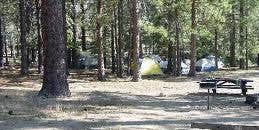
Enjoy a beautiful drive through the picturesque Cow Creek drainage on your way to one of the most interesting campsites in Umpqua. Located under a bluff and surrounded by a forest of cedar, pine, and madrone, Devil’s Flat is a small campground with three campsites, a bevy of hiking opportunities, and a handful of historic landmarks. On the north side of the campground, you can see the stone ruins of an old water fixture built by the CCC “Fire-Eaters” in the 1930s. On the south side is the old Devil's Flat Guard Station, where you’ll find a Ranger Cabin built in 1915 and a 1920s-era horse barn. On a fir tree near the Ranger Cabin, you can also see the tiki carving that gave Devil’s Flat its name. This good luck sign was carved by Ike French, a Hawaiian man who moved to the Cow Creek Valley region in the 1850s with his brother Sampson French; later, sometime around the 1930s, the tiki was misinterpreted by a new crop of settlers, who gave the area the name Devil’s Flat. As for hiking opportunities, Devil’s Flat offers easy access to beautiful hikes of varying length and difficulty: Cow Creek Falls Trail #1422 makes a 0.3 mile loop along cascading Cow Creek Gorge. Elk’s Skull Bluff Trail #1428A makes a 0.5 mile loop from the campground to a vantage point of the Upper Cow Creek drainage. Maranatha Trail #1422A travels 1.5 miles to a viewpoint over the Cow Creek drainage. Devil’s Flat Trail #1428 leads 5 miles to the top of Red Mountain. Facilities 3 campsites with picnic tables and fire pits No drinking water Vault toilet Garbage disposal Devil's Flat Campground - Cabin in open field Devil's Flat Campground - Historical Photo of campsite with people, horses, and tents
RV Road Trip Guides


Map & DirectionsDevil's Flat Campground is located in Oregon near Tiller
Directions
From Azalea, OR, travel east on County Road 36 for about 17 miles to Devil’s Flat Campground, located on the left side of the road.
Coordinates
42.97742039 N
122.68686075 W
Connectivity
 T-MobileNo Coverage
- VerizonNo Coverage
- AT&TNo Coverage
Connectivity
- T-MobileNo Coverage
- VerizonNo Coverage
- AT&TNo Coverage
Access
Site Types
- Tent Sites
Features
Drive Time
- 2 hrs 17 min from Medford, OR
- 2 hrs 22 min from Grants Pass, OR
- 3 hrs 9 min from Eugene, OR
- 4 hrs 15 min from Bend, OR

