Clay Creek Recreation Site operates within camping near BLM Land — Nw Oregon Siuslaw Field Office as a seasonal campground open from late May through early September. The Bureau of Land Management facility accommodates RVs up to 30 feet and offers both drive-in and boat-in access along Clay Creek.
Reaching the campground requires navigating a narrow, winding road with potholes and fallen branches that demands slow, careful driving. Sites feature picnic tables and fire rings, with vault toilets positioned across a paved parking area. The creek runs just a foot and a half deep near campsites, providing water sounds and a shallow swimming area. A hiking trail climbs 1,000 feet over 1.5 miles but becomes overgrown with brush in sections. Cell service disappears for approximately 15 miles around the area. Whittaker Creek Recreation Site provides another BLM option northwest for campers wanting easier road access.
Description
Overview
Overnight camping is closed until further notice. Day-use recreation areas remain open for public use.Reserve a campsite at Clay Creek on recreation.gov or pay when you arrive for non-reserved campsites using the Recreation.gov Mobile App. You must download before you reach the site since there is no cell reception in the drainage._Clay Creek Recreation Site is nestled in the Coast Range of Oregon between Eugene and the Oregon coast at an elevation of 436-492 feet. Located at the confluence of Clay Creek and the Siuslaw River, this recreation site offers a wealth of activities including forest hiking, fishing, wildlife viewing, picnicking and camping. The Springfield Office of the Northwest Oregon District of the Bureau of Land Management (BLM) manages the Clay Creek Recreation Site.
Recreation
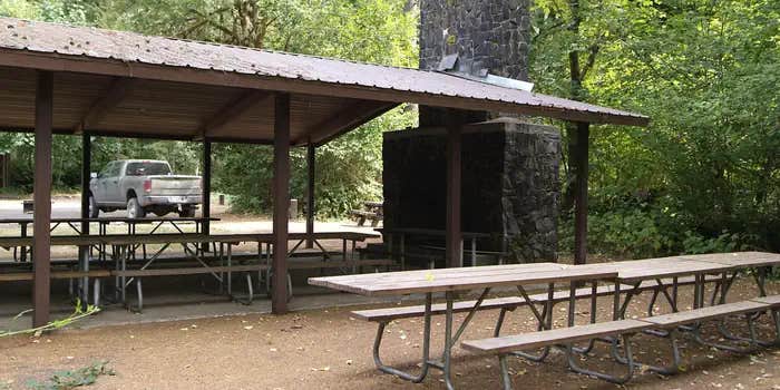
This quiet family oriented recreation site is a favorite if you enjoy riverside camping with an interpretive trail to old-growth timber. Spacious campsites with paved parking pads, mossy vine-maple tangles, and tall straight firs make up this camping area. The recreation site also boasts large group shelters available by reservation for group outings, weddings, or other events. The Clay Creek Trail, created in 1991 for hiking, provides access to a stand of Douglas fir high above the campground and the Siuslaw River. The sites Clay Creek Trail ascends a ridge above the campground to a remnant old-growth stand. From camp, you cross the concrete bridge on Clay Creek Road and river to begin the hike.
Facilities
Clay Creek offers 21 individual campsites to accommodate 32 feet of RV, truck and trailer, or tents. Most sites contain fire ring, barbeque grill, picnic table, and tent pad. In addition, the site contains vault toilets, a summer swimming area with dressing rooms nearby, individual picnic sites, a childrens play area, horseshoe pits, potable water, volleyball area (bring your net and ball), and a ball field.
Natural Features
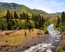
Clay Creek campground and the surrounding area are home to large canopy trees such as Douglas fir, western hemlock, red cedar, red alder and big leaf maple. The forest understory features a host of native plants like rhododendron, salal, various fern species, salmonberry and vine maple. On the forest floor, oxalis, Calypso orchids and mosses compliment the scenery. A diverse variety of bird life, from the seldom seen pileated woodpecker, northern spotted owl and marbled murrelet to the ever-present Oregon junco, frequent this area. Signs of larger animals, such as raccoon, mink, bear, elk, deer and beaver are evident. Clay Creek is part of the Siuslaw River watershed that drains water from the Coast Range to the Pacific Ocean. The river flows broad, cloudy, and green and calls to anglers; check current fishing regulations before casting your line. The Siuslaw River is a salmon watch site that runs fast and cold during the winter months, where you can observe spawning Coho and Chinook salmon in the rivers exceptional habitat during the fall and winter.
Nearby Attractions
Put-ins for the river downstream, along the Siuslaw River Road. No permit required to paddle the 6.5 mile river, with Class II - III rapids. Whittaker Creek Recreation Site (Florence) Alder Dune Campground (Florence) Archie Knowles Campground (Florence) B & E Wayside Mobile and RV Park (Cottage Grove) Baker Bay Campground (Dorena) Baker Bay County Park (Westfir) Bedrock Camp
Contact Info
This location is unstaffed. To speak with our main office for general information, please call: (541) 683-6600.
Charges & Cancellations
Standard fees apply and are non-refundable. Visit https://www.recreation.gov/rules-reservation-policies for more information.
Fee Info
Campsite fee includes one vehicle per site. Extra camping vehicle fee of $5 each is collected at the site. Cash or check, made out to Bureau of Land Management, is accepted. Fee envelope receipt stub must be displayed on the dash.
Warning 1 Alert is In Effect
There is 1 alert for this campground. Camp safely!
Warning 1 Alert is In Effect
There is 1 alert for this campground. Camp safely!
Overnight camping is closed until further notice. Day-use recreation areas remain open for public use.
RV Road Trip Guides

Map & DirectionsClay Creek Recreation Site is located in Oregon near Walton
Directions
From Eugene (valley): From Interstate 5 go west on Beltline Road to West 11th Avenue. Turn right onto West 11th Avenue (Highway OR-126). Follow Highway 126 about 29 miles to Siuslaw River Road just west of Walton. Turn left on Siuslaw River Road and follow about 10 miles to the intersection of BLM Road 19-7-20.1. Keep left on Siuslaw River Road for about 6 miles. The main entrance to the recreation site is located on the right. From Florence (coast): Take Highway OR-126 east about 14 miles to Mapleton. Turn right and follow Highway 126 for about 12 miles to Siuslaw River Road. Turn right on Siuslaw River Road and follow about 16 miles to the intersection of BLM Road 19-7-20.1. Keep left on Siuslaw River Road for about 6 miles. The main entrance to the recreation site is located on the right.
Address
No physical address
Walton, OR 97490
Coordinates
43.90508 N
123.56833 W
Connectivity
 T-MobileNo Coverage
 VerizonLTESome Coverage
- AT&TNo Coverage
Connectivity
- T-MobileNo Coverage
- VerizonLTESome Coverage
- AT&TNo Coverage
Access
- Drive-InPark next to your site
- Boat-InSites accessible by watercraft.
Site Types
- Tent Sites
- RV Sites
- Standard (Tent/RV)
- Group
- Tent Cabin
Features
For Campers
- Trash
- Picnic Table
- Drinking Water
- Pets
- Fires
Drive Time
- 1 hr 16 min from Eugene, OR
- 1 hr 42 min from Corvallis, OR
- 1 hr 52 min from Albany, OR
- 2 hrs 14 min from Salem, OR


