Best Dispersed Camping near Imnaha, OR

Primitive camping opportunities exist around Imnaha, Oregon, primarily in the Wallowa-Whitman National Forest and on BLM lands. Several dispersed sites are located along forest service roads, with notable areas including Hells Canyon Overlook near Saddle Creek, North Thomason Meadows, and Starvation Springs. These free sites generally have no developed facilities but provide access to scenic wilderness areas, including views of the Imnaha River canyon and surrounding mountains. Many sites allow camping for up to 14 days, though specific regulations may vary depending on the land management agency.

Access to dispersed camping locations typically requires travel on unpaved forest roads of varying quality. Several sites like North Thomason Meadows are accessible via gravel roads that may require high clearance vehicles, particularly after wet weather. The Hells Canyon Overlook area involves driving mountain roads with significant terrain changes. Many sites lack drinking water, restrooms, or trash facilities, requiring visitors to pack in all supplies and pack out all waste. Fire restrictions are common, especially during summer and fall, with complete bans possible during high fire danger periods.

The region provides excellent opportunities for solitude and connecting with nature, with many campers noting the exceptional stargazing and wildlife viewing. Most dispersed sites remain relatively uncrowded compared to developed campgrounds, though locations near water access points may see more visitors. Sites along the Imnaha River and its tributaries offer fishing opportunities and natural cooling during summer months. According to one visitor at Hells Canyon Overlook, "Tons of changes in terrain but the drive is not for the faint of heart. Be ready to share space with free roaming mountain cattle." Another camper at North Thomason Meadows noted the area features "a beautiful nine-mile hike into the forest" with "perfect getaway" conditions for those seeking to disconnect.

Detours Nearby

LOCAL FAVORITES PRESENTED BYToyota Trucks
Ice Lake

Ice Lake

1 hr 16 min away

Blackhorse Campground

Blackhorse Campground

1 hr 18 min away

2025 Detourist Giveaway

Presented byToyota Trucks

Review Campgrounds. Win Prizes.

Enter to Win

Best Dispersed Sites Near Imnaha, Oregon (25)

Show More
Showing results 1-10 of 25 campgrounds

2025 Detourist Giveaway

Presented byToyota Trucks

Review Campgrounds. Win Prizes.

Enter to Win


Dispersed Camping Reviews near Imnaha, OR

26 Reviews of 25 Imnaha Campgrounds


  • Arielle W.The Dyrt PRO User
    Oct. 4, 2020

    Echo Lake Dispersed Camping

    Gorgeous and remote. Be prepared to CLIMB!

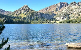
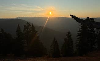
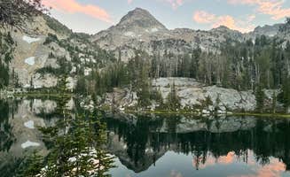
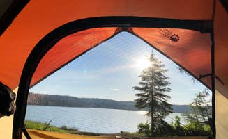
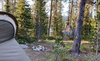
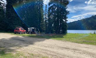
    This is not an official campground. There is a lot of space for campers, though, and it is not heavily trafficked. The trek to Echo Lake is about 8 miles (one-way) from the start of the Hurricane Creek Trail. When you arrive at Echo Lake, beauty awaits you! This location is a remote and peaceful retreat. The lake is so clear and serene. The views of the mountainside are breathtaking. This is a great site for groups and there is enough space to spread out. The stars are vivid and you can see the movement of the stars and moon along the mountains.  The trek to the lake is SO WORTH IT! This is probably one of the most beautiful places that I have ever been to. It gave me the wilderness escape that I needed. It is a hidden gem! Whenever you visit, leave your stressors behind you and enjoy the preserved beauty. The lake is very cold, but I definitely enjoyed the shock after the hike in! 

    The hike into Echo Lake is an intense incline! We tracked about 3,500 feet of elevation gain in about 5 hours during our hike in. The way back only took us about 3.5 hours and is mostly downhill. I would not recommend this hike for a beginner hiker/backpacker. I carried 60 lbs on my back up and down this trek and it was A LOT for me as a relatively new backpacker (with endurance conditioning). It is a hike that one should work towards, for sure! This trek is would be great crosstraining for an endurance athlete (like me!). At times, the incline felt like a 10-15% grade, but I do not know this for sure. It is pretty steep and challenging if you are carrying a lot of weight. I recommend going as minimalist as possible to avoid extra weight, if possible. I brought my bull mastiff dog along with me and she had a blast! I would recommend conditioning your dog for a trek like this. It can be pretty gnarly and steep at times! My dog wouldn't have made it if she had not done treks like this before. There are creeks along the route to the lake and I would bring extra water to hydrate your dog in between water sources. As always, leave no trace and keep this spot pristine and clean :)

  • Laura M.The Dyrt PRO User
    Apr. 6, 2025

    Pealy Loop Recreation Site Dispersed

    Great and free

    We came upon this site after passing on the White Bird Recreation Site just north of here - it's so much better and we're so glad we came here. It's an established campground, with maybe 4 or 5 sites, all open, spread out, right on the river. There's a picnic table and fire pit for each site, and a porta potty. Verizon was roaming and AT.T. had great reception. Despite being right off the main road, it was very quiet and you couldn't hear or see traffic since you're lower down on the river. Easy access for big rigs. We stayed here two nights. Ranger came through to check on things, always love to see that.

    Beautiful spot. Free! 14 day limit. No trash service, no water other than the river. The campground was nice and clean.

  • Alyse L.The Dyrt PRO User
    Nov. 8, 2023

    North Thomason Meadows

    Wildflowers, raptors, beautiful views at the top of Imnaha Canyon

    I recommend this section of Wallowa-Whitman NF Rd 46 (4600) between Thomason Meadow Guard Station and Buckhorn Lookout because it is grazed less than surrounding areas, and thus has more plant diversity--i.e. great WILDFLOWER BLOOM in the spring. At 5000 feet, June to early July is a peak bloom time.

    This is the top of the Imnaha River breaks, and you can see fully down into the BEAUTIFUL canyonlands of the Imnaha and Snake. Birdwatching was good for us out here too, especially raptors. One of the trailheads to the historic Nez Perce Nee -Me-Poo Trail is near this "Camp-1" dispersed spot.*

    *One of our maps calls the marked spot "FSR 46 Camp-1," but the dispersed camp sites are all along NF Rd 46 from here north to Buckhorn.

    The drive up to this area is well-maintained gravel, and an SUV with decent tires can do it. (We did it with a truck hauling a toy-hauler trailer). Bring all the water and supplies and tools you need--this area is REMOTE.

    Take Crow Creek Rd off of Hwy 82 (btwn Enterprise and Joseph). All is paved until your intersection with Zumwalt Road, where you veer R to stay on Zumwalt (aka Zumwalt-Buckhorn Rd). It's gravel after that intersection.

    Follow signs to Zumwalt Prairie or Buckhorn Lookout.

    Crossing over Zumwalt Prairie is a GORGEOUS drive. The Nature Conservancy has their Zumwalt Prairie Preserve here, and it's a great side trip from the camp spot.

    This section of NF-46 road is extremely quiet. Only the occasional ranch vehicle travels through. In fall this is a popular camp area for hunters.

    I gave it 4 stars instead of 5 because of zero water, zero data, the ecosystem/soil that has been abused in the past (not wilderness), the 50-minute drive to WiFi/ restaurant/ water refill/ black water dump. But if I was comparing primitive camping to primitive camping, this would be a 5 of 5.

    I would go back here (in late spring or early fall) in a heartbeat.

  • Nick J.The Dyrt PRO User
    Oct. 11, 2024

    Aneroid Lake Backcountry Dispersed Campsite

    Great Backcountry High Alpine Lake

    Aneroid Lake is one of my favorite locations in the Eagle Cap Wilderness. The dispersed camping for backpackers is on the North side of the lake, whereas the South side is private property (Camp Halton). The lake is stocked every few years with rainbow trout, and has a good supply of brook trout.

    The water is very cold but worth the dip if it's a hot summer day.

  • Marley F.
    Sep. 28, 2024

    Fiddle Creek Recreation Site

    Nice Spot

    My husband and I were looking for a quick spot to camp and found this right off the highway, it was perfect for a last minute camping. There’s a few more spots off the highway. We loved that it was right on the river, too. Pretty easy access, but if you have a longer trailer than I would suggest going in the first turn out, because the second one is tight.

  • DThe Dyrt PRO User
    Jul. 30, 2018

    Lost Valley Reservoir Dispersed Camping Area

    Beautiful Sunsets on a mountain lake.

    Once you turn off Hywy 95 on to Lost Valley Reservoir Road (about 16 miles North of Council), you will reach a Y in the well kept gravel road. If you turn left, you will come to Cold Spring Campground. There are RV/trailer and tent sites available for a small daily fee. There are campfire sites, hiking trails, toilets and water from a hand pump. You will need to pack out your own garbage as there are no dumpsters. Not a bad place but you are still about 1/2 mile away from the Lost Valley Reservoir.

    If you return to the Lost Valley Reservoir road, you can continue on to the Reservoir. After about 1/2 mile, you will see the lake off to your right. There are camp sites all along this stretch of the lake with direct access to the lake. A few sites have a common outhouse with no running water. Along this side of the lake there is also a boat launch area, but I believe this is a 'No Wake Lake'. Check local burn bans, and pack your garbage out.

    The road continues along the lake edge and over a small dam. There are several small, dirt access roads that lead to the lakes edge with camping sites at the end of each. Several roads are VERY rough and have deep ruts in them, and I personally wouldn't risk driving them without a vehicle that has plenty of clearance.

    The lake is small and as the summer progresses and water is drained from the reservoir, it shrinks. I prefer camping here until about the 1st or 2nd week of August. After this, the water levels drop drastically and green algae begins to accumulate around the lakes edge. There are small perch for fishing, but I did not catch any big enough to keep. We camped here in mid-July this year and had a campfire each night.

    Beautiful views, great hiking, refreshing water, and several families had ATV's. Huckleberries are usually ripe 1st/2nd weeks of August. Very relaxing. Enjoy.

  • Michael The Dyrt PRO User
    Jul. 4, 2021

    Ice Lake

    Nine-Mile Hike

    The water is no-joke cold. Fantastic nine-mile hike into the forest. Stayed two nights. Elevation is ~8,000 feet. Got altitude sickness on day two.

    No fires allowed. No amenities. Back-country hikers only. No cell service. Perfect getaway.

  • LThe Dyrt PRO User
    Sep. 18, 2024

    Red Bird Creek Trailhead

    Beautiful View, Long Hike

    Trailhead view is beautiful. Hike is down to the Snake River, which is over 5 miles each way. Major elevation change. Parking is free for up to 48 hours. No amenities. Small store and restaurant nearby.

  • Amanda P.The Dyrt PRO User
    Aug. 26, 2025

    Hells Canyon Overlook Near Saddle Creek - Dispersed Site

    A wonderful escape

    Tons of changes in terrain but the drive is not for the faint of heart. Be ready to share space with free roaming mountain cattle. Other than a forest service vehicle and maybe 2 others it was just us up there! We came by way of Imanha.


Guide to Imnaha

Dispersed camping near Imnaha, Oregon offers remote backcountry experiences in the transitional terrain between the Wallowa Mountains and Hells Canyon. The region sits at elevations ranging from 2,000 feet along the Imnaha River to over 8,000 feet at higher alpine sites. Most dispersed camping areas remain accessible from May through October, with snow possible at higher elevations until late June.

What to do

Hiking to alpine lakes: Ice Lake provides an ambitious backpacking destination with pristine mountain views. Located about 9 miles from the trailhead, this backcountry site sits at approximately 8,000 feet elevation. According to visitor Sarah W., "This backpacking trip is a very accessible hike. The road to get to the trailhead is paved and the hike to Ice lake is 9 miles in (18 miles total)."

River recreation: Free camping pullouts along the Little Salmon River provide direct water access for fishing, swimming, and paddling. Christian L. notes that Little Salmon River Pullout is "right on little salmon river" and "can fit a fairly decent amount of vehicles. The sign says you can camp up to 10 days consecutive."

Wildlife and wildflower viewing: North Thomason Meadows offers exceptional seasonal flora displays. Camp at higher elevations from June through early July for peak wildflower blooms. "I recommend this section of Wallowa-Whitman NF Rd 46 between Thomason Meadow Guard Station and Buckhorn Lookout because it is grazed less than surrounding areas, and thus has more plant diversity--i.e. great WILDFLOWER BLOOM in the spring," writes Alyse L.

What campers like

Solitude and quiet: Starvation Springs NF 46 Site offers accessible solitude without requiring extensive travel on rough roads. Kenny R. explains, "Not far up a nicely paved road, and then onto maybe 0.3-0.4 mile bumpy gravel/rock FS road. Plenty of large open sites with rock fire rings... It's also great that it isn't 5 miles down some super washboarded gravel road."

Stargazing conditions: The minimal light pollution around dispersed sites creates exceptional night sky viewing. According to Michael at Ice Lake, there are "No fires allowed. No amenities. Back-country hikers only. No cell service. Perfect getaway" conditions for those seeking dark skies.

Scenic drives: The routes to many dispersed sites offer remarkable scenery themselves. When traveling to North Thomason Meadows, Alyse L. points out that "Crossing over Zumwalt Prairie is a GORGEOUS drive. The Nature Conservancy has their Zumwalt Prairie Preserve here, and it's a great side trip from the camp spot."

What you should know

Weather considerations: Higher elevation sites experience significant temperature fluctuations. At Starvation Springs, Kenny R. reported "Mid 80's during the day in late July" despite the mountainous location.

Road conditions: Access varies widely between sites. For North Thomason Meadows, "The drive up to this area is well-maintained gravel, and an SUV with decent tires can do it. (We did it with a truck hauling a toy-hauler trailer)."

Cattle presence: Free-range cattle frequently share dispersed camping areas. Ranier E. notes that Hells Canyon Overlook provides a "Great Dispersed Camping Spot" but visitors should be prepared for wildlife encounters.

Water availability: No potable water exists at most sites. Laura M. notes at Pealy Loop Recreation Site there's "no water other than the river. The campground was nice and clean."

Frequently Asked Questions

Which is the most popular dispersed campsite near Imnaha, OR?

According to TheDyrt.com, the most popular dispersed campground near Imnaha, OR is Hells Canyon Overlook Near Saddle Creek - Dispersed Site with a 4.5-star rating from 2 reviews.

What is the best site to find dispersed camping near Imnaha, OR?

TheDyrt.com has all 25 dispersed camping locations near Imnaha, OR, with real photos and reviews from campers.