Beaverhead National Forest manages Notch Cabin, a Forest Service campground that operates with both drive-in and hike-in access options. The site provides drinking water, restroom facilities, and a dump station, though rough access conditions require careful navigation to reach the camping areas.
Located within forested terrain near a creek, the campground accommodates tent camping but restricts RV use with a zero-foot maximum length policy. Cell service reaches the area, and pets are welcome throughout the site. Campers seeking additional forest camping can explore campsites around Beaverhead National Forest. Reservations are available for those planning ahead.
Description
Overview
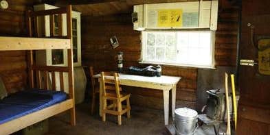
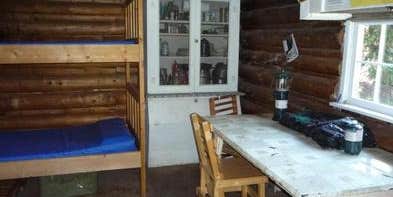
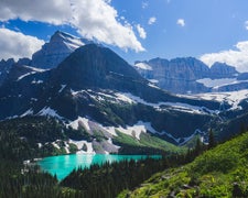
Notch Cabin is located in a remote part of southwestern Montana, within proposed wilderness, and is open from July 1 through November. It is somewhat difficult to access, but worth the trouble for outdoor enthusiasts. The cabin is used by big game hunters during hunting season. Hiking is available in the summer and fall. The cabin was built by a miner in the early 1900s. The surrounding landscape is thick with sage and grasslands, transitioning to timbered slopes that are full of wildlife. A high-clearance, four-wheel drive vehicle is required to access the cabin, which is located near the end of a very rough road. The cabin offers some basic amenities. Guests are responsible for their own travel arrangements and safety, and must bring most of their own supplies and gear.
Recreation
In addition to big game hunting, visitors can enjoy hiking, backpacking and horseback riding in the area. While no Forest Service trails are within the immediate vicinity of the cabin, the Snowcrest Trail is within a mile. It covers the entire range, providing panoramic views of the area. The 40-mile trail can serve as a hearty horseback riding adventure, a lengthy backpacking trip, or make for several day trips. The nearby seasonal mountain streams offer access to fishing. Anglers can enjoy a possible catch of brook trout, among other species. The wildlife management area is also good for hunting, but offers a perfect opportunity for visitors to catch a glimpse of wildlife in their natural habitat. Due to the high elevation and short growing season, recreational livestock is allowed only if supplemental feed (certified weed-free) is brought in. No pasture or corral is available. The final two miles of the access road to the cabin are not suitable for horse trailers.
Natural Features
The cabin is situated at an elevation of 8,470 feet in a notch between Olson Peak and Hogback Mountain on the Snowcrest Range. A small stream runs about 100 feet in front of the cabin. The Robb-Ledford Wildlife Management Area is nearby, which is an important elk and big game winter range that spans more than 28,000 acres in southwestern Montana. In addition to elk, the range is home to mule deer, upland birds and a growing population of grizzly bears (learn more about bear safety).
RV Road Trip Guides

Map & DirectionsNotch Cabin is located in Montana near Lima
Directions
Notch Cabin is about 62 miles from Ennis, Montana. The final 28 miles are gravel, dirt or primitive two-track. From Ennis, take Montana Highway 287 west for 23 miles to Alder. At Alder, turn south toward Ruby Reservoir (County 248) and travel 21 miles. Turn right on Ledford Creek Road (County 50) and travel southwest for 3 miles to signed junction. Turn right and after about 4.5 miles, you'll enter the Robb-Ledford WMA. Continue for 0.5 mile to junction, turn right and travel for 5 miles. This stretch of the road will split, with the option of going around or over a hill, then reconnecting a short distance later. After the 5 miles, the Springbrook road joins in from the west. Continue south toward the mountains and cross Ledford Creek after about 3.5 miles. Go 0.5 mile farther, and you'll reach the Forest Boundary. The cabin lies 1 mile beyond the boundary. The route is signed. You'll see the cabin straight ahead just as the road turns left across the creek. Driving time from Ennis is nearly 3 hours, with the last 9 miles taking over an hour. Cabin may also be accessed via Sweetwater Creek Road, then Springbrook road. This route is not signed. See map for details. Maps (Beaverhead-Deerlodge National Forest-South) may be purchased by calling the Madison Ranger District at 406-682-4253.
Address
5 FOREST SERVICE RD.
Ennis, MT 59729
Coordinates
44.8822111 N
112.1372306 W
Connectivity
 T-MobileNo Coverage
- VerizonNo Coverage
- AT&TNo Coverage
Connectivity
- T-MobileNo Coverage
- VerizonNo Coverage
- AT&TNo Coverage
Access
- Drive-InPark next to your site
- Hike-InBackcountry sites.
Site Types
- Cabins
Features
For Campers
- Phone Service
- Reservable
- Drinking Water
- Toilets
- Pets
For Vehicles
- Sanitary Dump
- Big Rig Friendly
Drive Time
- 3 hrs 31 min from Bozeman, MT
- 3 hrs 55 min from Helena, MT
- 4 hrs 22 min from Idaho Falls, ID
- 5 hrs 5 min from Pocatello, ID

