Public Campground
Gird Point
Gird Point is located in the Bitterroot National Forest, featuring forested terrain with mountain views. The area experiences temperature highs around 80°F in summer and lows near 20°F in winter. Nearby attractions include the Bitterroot River and Lake Como, offering opportunities for fishing and hiking.
Description
Overview
The Gird Point Lookout offers a unique chance to camp on top of a mountain peak in a rustic, old-time setting. It sits high above the valley and provides panoramic views of three surrounding mountain ranges. Comfortably equipped, the lookout tower provides almost everything anyone would need to enjoy a variety of recreational opportunities available in the mountains of western Montana.
Recreation
A variety of hiking and mountain biking trails are available in the area, as well as some off-road vehicle trails. The adjacent mountainsides have had several large fires in the last few decades and visitors will see a mosaic of recovering vegetation patterns. Hazardous snags still remain standing and hikers should use caution, especially during high winds. The lookout is known for its scenic views that can be enjoyed on just about any day of the year, regardless of current weather conditions. It provides a peaceful location to relax and enjoy nature. A variety of wildlife make its home in the area as well, providing ample sightseeing and wildlife viewing opportunities, from a vantage point at least 8 feet from the highest point in the region.
Facilities
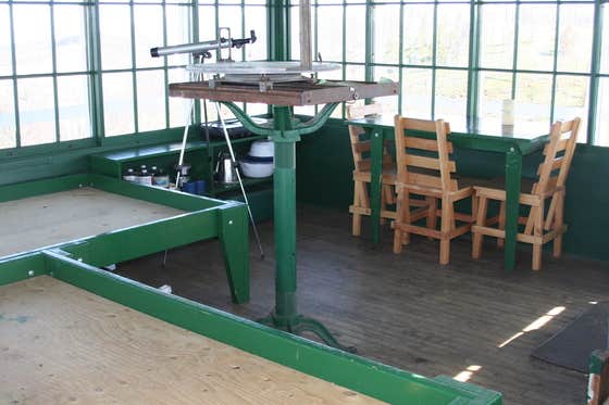
The 14-by-14 lookout is equipped with two beds that can sleep up to four people. It has a table and chairs, a propane stove and lantern, basic eating and cooking utensils and pots and pans, as well as a wood stove for heat and cooking. Firewood should be available at the tower but supply cannot be guaranteed. An outdoor toilet is also provided. Guests will need to bring their own water for drinking, cooking and cleaning purposes, as well as propane fuel canisters. Bedding, including mattress pads, is not provided. Visitors should plan to bring bedding, towels, soap, matches, garbage bags, toilet paper and food, among other necessities. Guests are required to pack out all trash and clean the cabin prior to leaving. Basic cleaning equipment is provided. No smoking or open flames (candles) in the Lookout. No fireworks. The lookout can be accessed by vehicle and then a short hike over a moderate grade for the remainder of the route. Guests are responsible for their own travel arrangements and safety. The historic L-4 cabin sits on top of an 8' high tower, with narrow steps and catwalk. This may pose a hazard for children and pets. Guests are responsible for their own safety.
Natural Features
The lookout is located 20 miles east of Hamilton, Montana, in the Bitterroot National Forest at an elevation of 7,702 feet. A 30-inch catwalk surrounding the glass-paneled room offers unobstructed views of the surrounding Sapphire, Bitterroot and Anaconda-Pintler mountain ranges. The 8-foot tower was originally built to watch for forest fires in the Hamilton/Skalkaho area, but it was later turned into a public recreation location. The lookout was restored beginning in 2001 and now has vintage 1940s furnishings.
Nearby Attractions
Highway 38 is also called the Skalkaho Highway. It continues into the Sapphire Mountains along a primitive and once widely used Native American trail. The scenic drive, which is closed during winter, was built to provide access between mining areas and agricultural communities in the Bitterroot Valley.
Location
Gird Point is located in Montana
Directions
From Hamilton, Montana, travel east on Highway 38 for about 7 miles. Turn north onto Gird Road/Forest Road 714 and continue for about 13 miles to the Gird Point Lookout Trailhead. The tower is approximately 1/2 mile hike from the parking area.
Address
P.O. BOX 388
Darby, MT 59829
Coordinates
46.207408868 N
113.909611476 W
Connectivity
- T-MobileNo Coverage
- VerizonNo Coverage
- AT&TNo CoverageVerified by 1 user
Connectivity
- T-MobileNo Coverage
- VerizonNo Coverage
- AT&TNo CoverageVerified by 1 user
Access
- Drive-InPark next to your site
Site Types
- Cabins
Features
For Campers
- Reservable
For Vehicles
- Pull-Through Sites
Drive Time
- 2 hrs 4 min from Missoula, MT
- 3 hrs 46 min from Helena, MT
- 4 hrs 31 min from Bozeman, MT
- 5 hrs 40 min from Lewiston, ID


