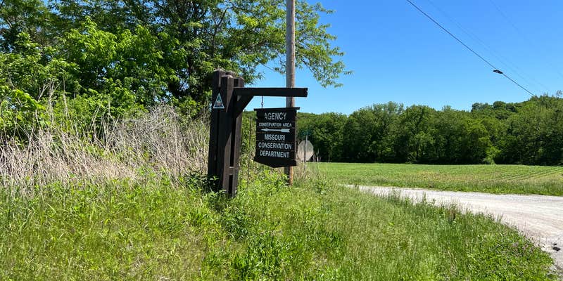
Fishing and wildlife viewing opportunities draw visitors to Agency Conservation Area, a Fish and Wildlife Service property offering free camping in northwest Missouri. The campground consists of a small gravel parking area accessed via well-maintained dirt roads, with tree coverage providing shade for campers.
Reviewers note the limited space, describing the camping area as roughly one-eighth of an acre with basic pullout-style sites. The conservation area features creek access and forested terrain, though dense vegetation may limit exploration during warmer months. Campers can bring pets and enjoy campfires, making this a straightforward option for campsites around Agency or a quiet overnight stop for those traveling through the region.
Description
The land for this area was donated to the Conservation Department in 1991. The timbered property straddles Rock Creek Road. The north tract of the area offers walk-in access to the Platte River. A graveled parking lot is located south of the county road. Both tracts are prone to flooding.
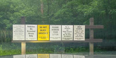
On department areas where camping is allowed, camping is limited to a period of 14 consecutive days in any 30-day period. Personal property must be removed at the end of the 14-day period. Unless a special use permit is obtained, total camping days on all department areas are limited to a total of 30 days within one calendar year. Groups of more than 10 people must obtain a special use permit prior to camping. To obtain a special use permit, contact the area manager at the phone number listed for this area in the area details section.
Quiet hours are in effect in camping areas from 10 p.m. to 6 a.m. daily. Visitors who are not occupying a campsite are required to leave the campground by 10 p.m. On camping areas with established campsites, only two camping or sleeping units are permitted in each site.
RV Road Trip Guides


Map & DirectionsAgency Conservation Area is located in Missouri near Agency
Directions
From Agency, take Highway FF/H/MM south 1.50 miles, then Rock Creek Road east 0.25 mile.
Coordinates
39.627407 N
94.730674 W
Connectivity
 T-Mobile5GGood Coverage
 VerizonLTESome CoverageVerified by 2 usersLast on 7/24/26
- AT&TLTESome Coverage
Connectivity
- T-Mobile5GGood Coverage
- VerizonLTESome CoverageVerified by 2 usersLast on 7/24/26
- AT&TLTESome Coverage
Access
- Drive-InPark next to your site
- Walk-InPark in a lot, walk to your site.
Site Types
- Tent Sites
- Group
Features
For Campers
- Alcohol
- Pets
- Fires
FREE established camping
Enjoy camping on government land. Limited or no services at this camping area.
PERMIT might be REQUIRED
We curate permit requirements across the US for our PRO members. Try PRO to see if Agency Conservation Area needs a permit.
Drive Time
- 12 min from St. Joseph, MO
- 44 min from Kansas City, MO
- 59 min from Lawrence, KS
- 1 hr 21 min from Topeka, KS


