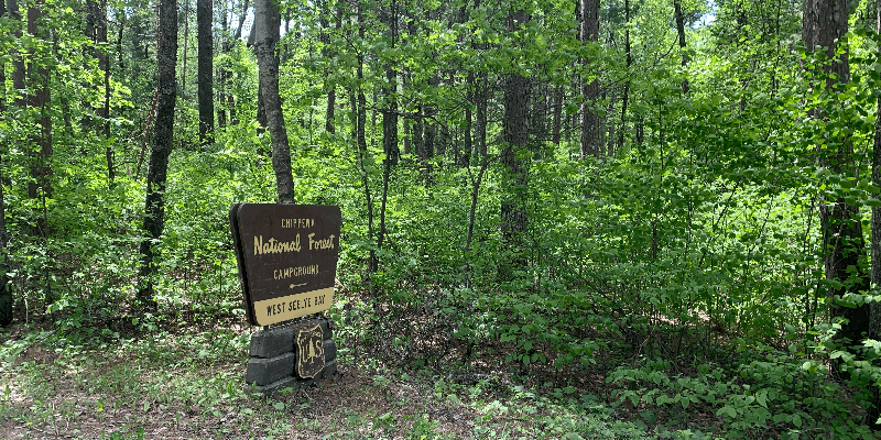
Deep wooded sites and water access define this Forest Service campground on Seelye Bay within Chippewa National Forest. The campground accommodates RVs up to 70 feet, though one reviewer notes most sites work better for tents and smaller rigs under 20 feet due to tight maneuvering. Sites extend well back from the road, providing natural separation between camping spots.
Scott M. found the campground full during his visit, despite some sites appearing less maintained. He noted the heavily wooded setting requires tick awareness for pets, pulling several off his dog during their stay. Campers seeking different site layouts can check East Seelye Bay Campground just 0.3 miles east.
Description
West Seelye Bay provides 22 campsites and access to the boat ramp near the East Seelye Bay picnic Area. The campground is located on Cut Foot Sioux Lake which is well known for its excellent walleye and northern pike fishing. (This campground usually closes after the 4th of July weekend.) | Site Map
RV Road Trip Guides

Map & DirectionsWest Seelye Bay is located in Minnesota near Chippewa National Forest
Directions
From Deer River, MN, take US Rt. 2 west 0.8 miles to State Rt. 46. Turn right onto Rt. 46 and go 19.1 miles to Eagle Nest Rd. Turn left onto Eagle Nest Rd. (dirt and gravel) and go 3 miles to campground sign on left.
Coordinates
47.52400089 N
94.10200055 W
Connectivity
 T-MobileNo Coverage
 VerizonLTESome CoverageVerified by 4 usersLast on 7/26/26
- AT&TLTESome Coverage
Connectivity
- T-MobileNo Coverage
- VerizonLTESome CoverageVerified by 4 usersLast on 7/26/26
- AT&TLTESome Coverage
Access
- Drive-InPark next to your site
Site Types
- Tent Sites
- RV Sites
Features
For Campers
- Drinking Water
- Toilets
- Pets
Drive Time
- 2 hrs 5 min from Duluth, MN
- 2 hrs 54 min from Grand Forks, ND
- 2 hrs 58 min from St. Cloud, MN
- 3 hrs 12 min from Fargo, ND


