Hiking and swimming opportunities draw campers to this state forest campground, which sits alongside a small pond in north-central Massachusetts. The facility operates from mid-May through mid-October with sites accommodating tents through RVs up to 28 feet, though several reviewers note the access road can be challenging for larger rigs.
Site selection matters here. The campground consists of several loops, with sites near the pond offering more space and privacy than those on the inner loops. Jean C. notes that "sites that are near the small pond are generally larger and have better space for pitching a tent," while sites 65, 67, and 68 are walk-in options positioned closer to the water. Site 28 receives particular praise for feeling most secluded within the forest setting.
Swimming happens in two small, roped-off areas of the pond, though the depth limits activities to quick cooling-off dips rather than extended water play. Floats are not permitted in these designated swim zones. Trail access provides hiking and biking opportunities throughout the forest, and Jamal C. found "lots of trails for hiking and biking" during his stay. Additional water activities are available at the dump station location down the road at Lake Dennison.
Cell service varies significantly by carrier and location within the campground, with Verizon users reporting better connectivity than AT&T customers. The facility maintains clean bathrooms and provides electric, water, and sewer hookups for RVs, though the maximum length restriction keeps larger rigs away. Reservations are available through the state park system.
Campers seeking more spacious sites might consider Lake Dennison Recreation Area Campground, located just north with expanded water recreation options.
Description
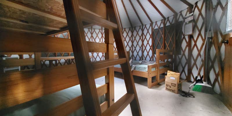
NATURAL FEATURES Otter River State Forest was the first area acquired by the State Forest Commission in 1915 and also the first campground in the Massachusetts State Park system. Some of the forest area was cleared in the nineteenth century for small farms. After the state acquired the land, it was reforested with groves of pines which were planted by the Civilian Conservation Corps in the 1930's. The forest of oak and hickory, northern hardwood and pines is home to numerous wild flowers and shrubs, deer, chipmunks and many species of birds. RECREATION Otter River State Forest is a popular camping and day-use facility in a beautiful area of north central Massachusetts. Its developed facilities are centered on Beaman Pond and include ball field, basketball court, volleyball court and picnic areas. Many recreation opportunities are available and include a fishing, hiking, hunting, mountain biking, and picnicking. Use the park's hiking trails or try mountain biking on the 9000 acres of the adjacent Birch Hill Wildlife Management Area. FACILITIES Otter River offers 73 campsites, three group sites, and four yurts. Comfort stations are located throughout the campground and offer hot showers and flush toilets. One comfort station is accessible, shown on the map. Each campsite is equipped with a picnic table and a fire ring. Yurts are canvas sided, cabin-like structures that can accommodate 4 to 6 people. Yurts offer bunk beds, tables with benches, and access to water and electricity. All of the yurts are accessible. (Linens and eating utensils are not provided.) NOTE: Electrical service is not sufficiently reliable for use with medical equipment. Pets are prohibited from yurts and yurt sites.
Warning 4 Alerts are In Effect
There are 4 alerts for this campground. Camp safely!
Warning 4 Alerts are In Effect
There are 4 alerts for this campground. Camp safely!
**Walk-in Registrations are not permitted. Advance Reservations can be made same day up until 2 pm on date of arrival.**
Please note that firewood sales are by credit card only, and effective 2021, the cost of firewood is $7 per bundle. Massachusetts prohibits the transportation of firewood or any wood products into or out of any DCR campground.
There is a 6-ton limit for the bridge in the campground. RVs weighing more than 6 tons cannot access sites 28-78.
April 1 through Labor Day Monday, the booking window will be open for new inventory at 8 am ET daily. During the off season, inventory opens at 9 am on weekdays and 10 am on weekends.
RV Road Trip Guides

Map & DirectionsOtter River State Forest is located in Massachusetts near Baldwinville
Directions
From the East: Rte. 2 West to Exit 82, right on Baldwinville Rd. to the end, then right onto Rte. 202. Go 1.2 miles on Rte. 202 North to the Park entrance on the left. From the West: Follow Rte. 2 East to Exit 79. Turn right onto Rte. 202 North and travel 4.7 miles to the Park entrance on left. Campground Address: 86 Winchendon Road Baldwinville, MA 01436 Campground Phone Number: Headquarters number: 978-939-8962
Address
86 Winchendon Road
Baldwinville, MA 01436
Coordinates
42.62549439 N
72.07935375 W
Connectivity
 T-Mobile5GExcellent CoverageVerified by 4 usersLast on 6/27/26
- Verizon5GExcellent CoverageVerified by 4 usersLast on 6/27/26
- AT&T5GExcellent Coverage
Connectivity
- T-Mobile5GExcellent CoverageVerified by 4 usersLast on 6/27/26
- Verizon5GExcellent CoverageVerified by 4 usersLast on 6/27/26
- AT&T5GExcellent Coverage
Access
- Drive-InPark next to your site
Site Types
- Tent Sites
- RV Sites
- Standard (Tent/RV)
- Dispersed
- Group
- Cabins
- Tent Cabin
- Yurts
Features
For Campers
- Picnic Table
- Reservable
- Electric Hookups
- Pets
- Fires
For Vehicles
- Sanitary Dump
- Sewer Hookups
- Water Hookups
- Pull-Through Sites
- 30 Amp Hookups
- 50 Amp Hookups
- Big Rig Friendly
Drive Time
- 42 min from Worcester, MA
- 47 min from Amherst Center, MA
- 1 hr 8 min from Springfield, MA
- 1 hr 13 min from Manchester, NH


