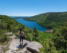
Accessible year-round via forest roads, Deboullie Public Reserved Land provides primitive camping within Maine's North Woods region. This public reserved land operates under state management, offering dispersed camping opportunities for self-sufficient campers. The area spans thousands of acres of working forest land with multiple access points.
Sites lack hookups, restrooms, and potable water, requiring campers to bring all necessary supplies. The terrain includes mixed hardwood and softwood forests with several small ponds scattered throughout the property. Campers seeking more developed facilities can find St Froid Lake Camps and Campground about seven miles northeast.
RV Road Trip Guides

Map & DirectionsDeboullie Public Reserved Land is located in Maine near Eagle Lake
Directions
From the north, travel on Route 161 to the St. Francis checkpoint, paying the user fee (see Special Considerations). Proceed south approximately 8 miles on the St. Francis Road to reach the western boundary of the Deboullie lands. This road is open late spring through fall. From the south, take route 11 North form Ashland to Portage and turn left onto West Raod (before reaching the lake). After 1 mile, turn left onto a gravel logging road (by signs for several sporting camps). You will pass the Fish River checkpoint and pay use fee after about 4 miles. After 2 miles, turn right on Hewes Brook Road and follow that approximately 20 miles to the Deboullie Public Lands.
Coordinates
46.90348607 N
68.67230418 W
Connectivity
 T-MobileNo Coverage
- VerizonNo Coverage
- AT&TNo Coverage
Connectivity
- T-MobileNo Coverage
- VerizonNo Coverage
- AT&TNo Coverage
Access
Features
Drive Time
- 2 hrs 49 min from Bangor, ME
- 4 hrs 14 min from Lewiston, ME
- 4 hrs 51 min from Portland, ME
- 8 hrs 1 min from Burlington, VT

