
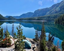
Within the Boise National Forest, Queens River provides a forested camping experience alongside flowing water from May through October. This US Forest Service campground sits near both a creek and river, offering sites with picnic tables and fire rings. Basic vault toilets serve the area, and pets accompany campers throughout the grounds.
The campground's riverside location puts campers close to water access while maintaining tree cover. Nearby options include Riverside and Beaver Lodge campgrounds, both within five miles. Queens River works well for campers who want water proximity and forest camping with standard amenities during the warmer months.
Description
Overview: Queens River Campground is located near Atlanta, Idaho. There are 4 campsites are along the Middle Fork of the Boise River. Just north of the campground, at the end of Forest Service road 206, is a trailhead which enters the Sawtooth Wilderness and follows along the Queens River. The trailhead west of the campground, along Eagle Creek, connects to Black Warrior Trail, a multiuse trail which heads north.
RV Road Trip Guides

Map & DirectionsQueens River is located in Idaho near Atlanta
 Public Campground
Directions
From Boise, Idaho, travel State Highway 21 north to the turnoff of the Arrowrock Reservoir. Travel east along Forest Service (FS) Road 268 (Middle Fork Boise River Road) approximately 62 miles. You will travel past the Arrowrock Dam and several other campgrounds before arriving at Queens Campground. FS Road 268 is very narrow and may be rough. Use caution when driving to your site. Allow plenty of time.
Coordinates
43.82100015 N
115.21000018 W
Connectivity
 T-MobileNo Coverage
- VerizonNo Coverage
- AT&TNo Coverage
Connectivity
- T-MobileNo Coverage
- VerizonNo Coverage
- AT&TNo Coverage
Access
Site Types
- Tent Sites
Features
For Campers
- Picnic Table
- Toilets
- Pets
- Fires
Drive Time
- 3 hrs 1 min from Boise, ID
- 3 hrs 37 min from Twin Falls, ID
- 4 hrs 47 min from Idaho Falls, ID
- 4 hrs 55 min from Pocatello, ID

