Deep within Tate's Hell State Forest, this primitive campground sits along Juniper Creek with sites that stretch miles apart from each other. Campers drive in to reach individual sites equipped with picnic tables, grills, and fire rings, though the forest roads require careful navigation. Full RV hookups for electric, water, and sewer are available despite the primitive designation.
The secluded setup means neighbors remain distant, with each campsite functioning as its own isolated base camp. Reservations cost $15.90 and must be made by phone with card payment, contrary to some listings that suggest free camping. Hikers and kayakers use the sites to access forest trails and creek paddling, while the camp store provides basic supplies for extended stays in this expansive state forest system.
Description
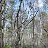
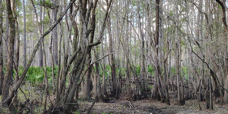
The Juniper Creek Primitive Campsites are in Tates Hell State Forest (Franklin County). There are eight tent or RV accessible primitive campsites: New River sites #2 through 7, Boundary Road and Bus Stop. New River sites #2 through 7 are along the east side of the New River, and Boundary Road is near Juniper Creek; however, Bus Stop is not located along a waterway. Going north of Carrabelle, FL, the closest campsite is New River #2, about 13 miles (25-minute drive) and the furthest campsite is Boundary Road, about 21 miles (35-minute drive). None of these primitive campsites have electricity, water, or restrooms. New River #5 and Boundary Road have water access that feeds into the river. Recreational activities featured here are: fishing, canoeing, kayaking, hiking, picnicking, bird watching, wildlife viewing and photography.
No water at campsite.
Must have off-highway vehicles permit to ride ATV/OHV/ROV within the OHV area surrounding the campsites.
If you have non-emergency situation and need assistance between 5:00 pm - 8:00 am, please contact Florida Forest Service Dispatch at (850) 681-5950.
Warning 1 Alert is In Effect
There is 1 alert for this campground. Camp safely!
Warning 1 Alert is In Effect
There is 1 alert for this campground. Camp safely!
Drought conditions continue to worsen, and numerous Florida counties have implemented burn bans. State Forest campgrounds within counties under a burn ban are subject to the same restrictions, which may affect your camping experience. Please check the Burn Ban Public Dashboard and plan accordingly before making a reservation.
RV Road Trip Guides


Map & DirectionsNew River is located in Florida near Carrabelle
Directions
**GPS Info** 12 New River: 29.9635 -84.7225 13 New River: 29.9708 -84.7261 14 New River: 29.9820 -84.7334 15 New River: 29.9889 -84.7374 16 New River: 29.9931 -84.7449 17 New River: 30.0102 -84.7554 18 Boundary Road: 30.0337 -84.7469 22 Bus Stop: 29.9815 -84.6266 12, 13 ,14 and 15 New River campsites: From CR 67, turn onto Gully Branch Road and travel about 5.7 miles; turn right onto E. River Road. 12 New River campsite access road is 0.5 mile ahead on your left; 13 New River campsite access road is 1 mile ahead on your left; 14 New River campsite access road is about 1.8 mile ahead on your left; For 15 New River campsite, travel 2.6 miles on E. River Road and take a left onto Rock Landing Road, campsite is at the end of the road. 16 and 17 New River campsites: From CR 67, turn onto Rock Landing Road heading west and travel about 7.5 miles; turn right onto E. River Road. 16 New River campsite access road is about 0.7 mile ahead on your left; 17 New River campsite access road is about 1.8 miles ahead on your left. 18 Boundary Road: From CR 67, turn onto Boundary Road. The campsite is about 7.3 miles ahead at the end of the road. 22 Bus Stop: From CR 67, turn onto Rock Landing Road heading west and travel about 1.5 miles; turn left onto School Bus Road. The campsite is 0.7 mile ahead at the end of the road.
Address
East River Rd, Bus Stop Camp Rd.
Carrabelle, FL 32322
Coordinates
29.96314904020183 N
84.7242522002024 W
Connectivity
 T-MobileNo Coverage
- VerizonNo Coverage
- AT&TNo Coverage
Connectivity
- T-MobileNo Coverage
- VerizonNo Coverage
- AT&TNo Coverage
Access
- Drive-InPark next to your site
Site Types
- Tent Sites
- RV Sites
Features
For Campers
- Market
- Picnic Table
- Reservable
- Electric Hookups
- Toilets
- Pets
- Fires
For Vehicles
- Sewer Hookups
- Water Hookups
- 30 Amp Hookups
- 50 Amp Hookups