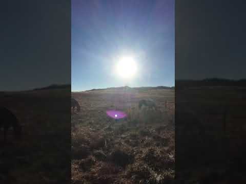
Campsites cut into the east ridge of Pinewood Reservoir give most sites a direct view across the water toward the surrounding foothills, a layout that sets this Larimer County campground apart from flatground alternatives. The road in climbs steeply with winding curves, and while reviews note the paved surface holds up well in dry conditions, the grade may be a challenge for large RVs. Sites themselves are relatively small. One camper describes each site as "dugout into the hillside, with a perfect view of the lake," which captures the terraced feel of the campground's layout along the ridge.
Shade varies noticeably across the campground. Sites shaded by large pines sit toward the upper sections, while sites closer to the beach area have little to no tree cover. The beach drew complaints in at least one summer review, with broken glass noted as a hazard near the water's edge. Sites are spread out enough to give some breathing room between neighbors, though several reviewers mention the campsites are visible from the road and privacy is limited. A handful of houses border the property, which affects the sense of seclusion for some visitors.
Full hookups, including electric, water, and sewer, are available at the 16 RV sites. Nine walk-in tent sites sit on the hillside above. The reservoir allows only non-motorized watercraft, and a roughly three-mile loop trail circles the lake. Fishing is possible, though reviews describe it as decent rather than exceptional. Cell coverage is unreliable, but over-the-air TV reception from Denver stations comes in clearly. Campfires are permitted, and the campground is ADA accessible. Flatiron Reservoir Campground is another option in the same county system for those comparing nearby sites.
The campground stays open into late fall and can be quiet on shoulder-season weekdays. An October visitor noted the restrooms were open and electricity was running during the first snowfall of the season, making it a workable late-season destination for campers with hookup rigs. Note that Larimer County charges both a park entry fee and a separate campsite fee. Reservations are available and worth booking ahead for summer weekends, when the campground fills and the beach area gets busy.
Description
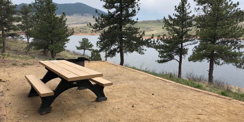
Pinewood Reservoir is located west of Carter Lake at an elevation of 6,580 feet. Pinewood is 100 acres of water surrounded by 327 acres of public land. It is popular for trout fishing and camping. The campground is newly remodeled and has drive in electric sites as well as walk in tent sites overlooking Pinewood Reservoir. The reservoir is part of the Colorado-Big Thompson Project operated by the Bureau of Reclamation and the Northern Colorado Water Conservancy District. The purpose of this water project is to divert water from the west slope to the east slope for drinking water, irrigation, and hydropower generation. Reclamation is solely responsible for power generation. The agencies jointly manage water levels for irrigation, municipal, and industry use. Recreation is managed by Larimer County Natural Resources.
Brand new, 15 standard drive in electric sites and 12 walk-in tent sites are found at Pinewood. There are vault toilets and water spigots throughout the campground in addition to day use parking, picnicing, and a natural play area.
Warning 3 Alerts are In Effect
There are 3 alerts for this campground. Camp safely!
Warning 3 Alerts are In Effect
There are 3 alerts for this campground. Camp safely!
Increased fire restrictions are currently in effect for unincorporated Larimer County. For more info, view the press release,.
Pinewood Reservoir is only accessible by a narrow 4 mile paved road with extreme, 8-10% grades. Most sites are small. NOT RECOMMENDED FOR LARGER RV's AND MOTORHOMES!
Increased fire restrictions are currently in effect for unincorporated Larimer County. For more info, view the press release,.
RV Road Trip Guides

Map & DirectionsPinewood Reservoir Campground is located in Colorado near Drake
Directions
Take I-25 to Berthoud Exit (Exit 250). Turn left (West) onto Highway 56 and continue for 9.5 miles, passing through town of Berthoud. At the foothills, the road will turn sharply to the right (north). Turn Left (west) onto County Road 8E and continue for 3 miles to the entrance station where you can purchase permits. Follow County Road 8E west to the intersection with County Road 31 and continue around the lake for 5.5 miles to the intersection and County Road 18E. Turn left (west) and continue about 4.5 miles to the lake.
Address
1800 SOUTH COUNTY ROAD 31
Loveland, CO 80537
Coordinates
40.36508215 N
105.28461336 W
Connectivity
 T-MobileNo Coverage
- VerizonNo Coverage
- AT&TNo Coverage
Connectivity
- T-MobileNo Coverage
- VerizonNo Coverage
- AT&TNo Coverage
Access
- Drive-InPark next to your site
- Walk-InPark in a lot, walk to your site.
- Boat-InSites accessible by watercraft.
Site Types
- Tent Sites
- RV Sites
- Standard (Tent/RV)
Features
For Campers
- ADA Access
- Reservable
- Electric Hookups
- Toilets
- Pets
- Fires
For Vehicles
- Sewer Hookups
- Water Hookups
- Pull-Through Sites
- 30 Amp Hookups
- 50 Amp Hookups
Drive Time
- 46 min from Fort Collins, CO
- 50 min from Greeley, CO
- 59 min from Boulder, CO
- 1 hr 17 min from Denver, CO