Within Arapaho National Forest, South Fork Group Site provides a reservations-only camping option for larger parties willing to navigate rough access roads. The US Forest Service manages this $70-per-night site, which accommodates RVs up to 30 feet and includes drinking water, toilets, and trash service alongside pet-friendly policies.
The forested terrain opens near a creek, creating fishing opportunities for groups seeking water access. Campers can find campgrounds near Arapaho National Forest throughout the region, though this particular site caters specifically to organized groups rather than individual campers. The combination of group-only reservations and challenging road conditions makes this location best suited for coordinated parties with suitable vehicles.
Description
Overview
South Fork Group Campground is located in north central Colorado in the Williams Fork Valley next to South Fork Creek. Many mountain streams and creeks nearby offer good fishing opportunities. South Fork is the only facility in the area designated for horse camping.
Recreation
The South Fork Trail begins at the campground and is one of the most popular trails in the valley. The 26-mile loop trail is open to hiking and horseback riding, and provides access to other trails in the area, including Ptarmigan Pass, Ute Peak and Jones Pass Trails. Mountain biking opportunities also exist in the valley. The Byers Peak Wilderness can be accessed nearby. Anglers enjoy trout fishing on the South Fork Creek and numerous additional streams and creeks in the surrounding area. Wildlife viewing opportunities abound.
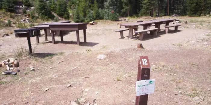
Facilities
The campground offers one reservable, accessible group site that can accommodate up to 25 people. Individual sites are available on a first-come, first-served basis. Picnic tables, campfire rings and tents pads are provided, as are flush and pit toilets and drinking water. A small corral, for one or two horses, is located in the campground.
Natural Features
The campground is located in the Williams Fork Valley next to South Fork Creek at an elevation of 8,962 feet. A cool mountain climate with frequent afternoon thunderstorms should be expected. Due to the pine beetle infestation and hazardous tree removal, shade has been reduced throughout the campground. The Arapaho and Roosevelt National Forests and Pawnee National Grassland sit on the foothills and peaks of the Rocky Mountains in Colorado. The forests and grassland cover 1.5 million acres and extend north to the Wyoming border, south to Mount Evans and west across the Continental Divide.
Charges & Cancellations
Modifications for this campground must be made through Recreation.gov or by calling the call center at 1-877-444-6777 PRIOR to your reservation start date. Customers and contact center agents cannot modify reservations on or after the check-in date.
RV Road Trip Guides


Map & DirectionsSouth Fork Group Site is located in Colorado near Silverthorne
Directions
From Granby, Colorado, take State Highway 40 west toward Parshall, Colorado. Two miles before Parshall, turn left on County Road 3. Go approximately 18 miles on County Road 3. Turn south onto County Road 30 and travel 12 miles. Drive through a large culvert. Continue south for a half-mile and turn right into the campground.
Address
COUNTY ROAD 30
Parshall, CO 80468
Coordinates
39.7940528 N
106.0306278 W
Connectivity
 T-MobileNo Coverage
- VerizonNo Coverage
- AT&TNo Coverage
Connectivity
- T-MobileNo Coverage
- VerizonNo Coverage
- AT&TNo Coverage
Access
- Drive-InPark next to your site
Site Types
- Tent Sites
- RV Sites
- Standard (Tent/RV)
- Group
Features
For Campers
- Trash
- Reservable
- Drinking Water
- Toilets
- Pets
Drive Time
- 1 hr 56 min from Denver, CO
- 2 hrs 5 min from Boulder, CO
- 2 hrs 37 min from Greeley, CO
- 2 hrs 41 min from Fort Collins, CO

