Dirt roads wind through forested terrain to reach this group campground at elevation in the Shasta National Forest, where campers find fire pits scattered among the trees and ample space between sites. The campground accommodates RVs up to 25 feet and accepts both reservations and walk-in camping, though recent visitors report mixed messaging about availability requirements.
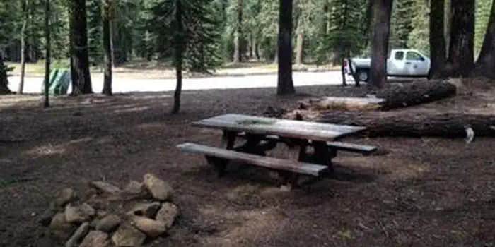
Red fir and other conifers provide natural boundaries throughout the camping area, creating defined spaces without formal site markers. Multiple fire rings dot the landscape, and campers note the abundance of trees offering varying degrees of shade. Cell service reaches the area, and the $12 nightly fee covers basic amenities including picnic tables. Road conditions become challenging after dark, as one reviewer noted: "show up during daylight because the dirt roads are a little bumpy and so hard to see after dark."
The location serves as a staging point for Mount Shasta climbers heading to Helen Lake, with rangers stationed nearby during climbing season to provide route information. Four-wheel drive enthusiasts find additional recreational opportunities in the surrounding forest roads. For more camping choices, campsites near Mount Shasta include both developed and dispersed options within the national forest.
This campground works well for groups seeking a forested base camp with vehicle access and basic facilities, particularly those planning mountain adventures or exploring the area's backcountry roads.
Description
Overview
Red Fir Flat Group Campground is located on the southern slope of Mt. Shasta at 6,400 feet in elevation. Snowpack in this location may extend into late June on heavy snow years, and usually sees late season snowfall in early November, possibly October. It is a popular site for meditation/retreat groups. Maximum stay limit is 7 days per group and or indvidual(s)
Recreation
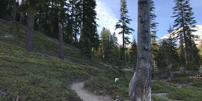
Most visitors enjoy the peace and solitude of the forest setting. Several hiking trails are located nearby, including the trail to the historic stone cabin at timberline owned and operated by the Sierra Club Foundation. Also within a few miles are Upper and Lower Panther Meadows, the access trail to South Gate Meadows and the trail to Gray Butte.
Facilities
Facilities include several picnic tables, an established fire ring, bear proof trash recepticles and vault toilet. Limited garbage service is provided and visitors are asked to pack out what they can. There is no water at this site; please bring your own. Campfires are allowed with a California Campfire Permit. Gathering of dead and down firewood is allowed for use while in the campground.
Natural Features
The campground is situated in an old growth forest of Shasta red fir. The forest provides plenty of shade and has open sunny spots as well. There is no view of the upper mountain from this location; however, views to the west and south include the Trinity Alps, Mount Eddy, and Castle Crags.
Nearby Attractions
The area offers hiking trails, mountain bike trails, and climbing routes to the summit of Mt. Shasta. Mt. Shasta City is 10 miles away and provides full services including grocery stores and restaurants.
Charges & Cancellations
A $10.00 service fee will apply if you change or cancel your reservation. Late cancellations are subject to additional fees. For full details see NRRS Reservation Policy.
RV Road Trip Guides


Map & DirectionsRed Fir Flat Group Campground is located in California near Mount Shasta
Directions
From Interstate 5, take exit number 738. Head east through the town of Mt. Shasta on Lake Street. Lake Street becomes the Everitt Memorial Highway as it ascends the mountain. At about milepost 9, look for the campground entrance sign on the left.
Address
204 West Alma Street
Mount shasta, CA 96067
Coordinates
41.3438889 N
122.2533333 W
Connectivity
 T-Mobile5GGood CoverageVerified by 1 userLast on 7/31/26
 VerizonLTESome CoverageVerified by 9 usersLast on 7/31/26
- AT&TLTESome CoverageVerified by 1 userLast on 7/11/26
Connectivity
- T-Mobile5GGood CoverageVerified by 1 userLast on 7/31/26
- VerizonLTESome CoverageVerified by 9 usersLast on 7/31/26
- AT&TLTESome CoverageVerified by 1 userLast on 7/11/26
Access
- Drive-InPark next to your site
- Walk-InPark in a lot, walk to your site.
Site Types
- Tent Sites
- RV Sites
- Standard (Tent/RV)
- Group
Features
For Campers
- Picnic Table
- Phone Service
- Reservable
- Alcohol
- Pets
- Fires
For Vehicles
- Big Rig Friendly
Drive Time
- 2 hrs 13 min from Redding, CA
- 3 hrs 20 min from Medford, OR
- 3 hrs 47 min from Grants Pass, OR


