Dispersed camping near Lake Hughes, California centers around mountainous terrain with elevations ranging from 2,300 to 4,500 feet, creating significant temperature variations between seasons. The region sits at the convergence of Angeles National Forest and Mojave Desert ecosystems, which creates distinct camping conditions. Fire restrictions apply seasonally throughout most primitive sites, with enforcement typically stricter during summer months.
What to do
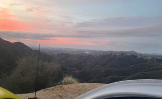
Night sky viewing: Angeles Crest Overlook provides unobstructed views of celestial objects away from city light pollution. One camper noted, "The view is gorgeous in the morning sunrise!" while another mentioned the area has "Dark, fairly quiet, good view!"
Off-road exploration: Jawbone Canyon OHV Area offers trails catering to various skill levels. A visitor described, "Lots of trails to ride - for beginners to advanced. We zipped around in a side by side and everyone was responsible and nice."
Hiking: Big Cone Camp provides access to Santa Paula Canyon with water features. As one hiker described, "From Big Cone Camp you can easily reach the waterfalls and pools that make this area known as the punch bowls."
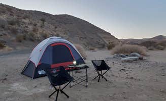
Wildlife observation: The transition zone between forest and desert ecosystems supports diverse wildlife. Joshua trees dot the landscape at East Mojave Camp, where a camper noted, "Several Joshua Trees" and another mentioned experiencing a "Beautiful sunrise."
What campers like
Solitude: Many primitive sites offer privacy from neighboring campers. At East Mojave Camp, one visitor reported, "Very remote absolutely nothing out there... We were the only people there."
Accessibility: Some areas remain accessible year-round. Jawbone Canyon offers "endless dispersed camping options in a beautifully rugged canyon" with a reviewer noting "There are sites that would be accessible by car as well just be more discerning."
Cost-effective: Free camping provides economical alternatives to developed campgrounds. A Jawbone Canyon visitor summed it up: "Hey, it's free. Weekends are busy but weekdays are exceptionally peaceful."
Scenic vistas: The region offers distinctive views of both mountain and desert landscapes. One camper at Angeles Crest described it as "just a few parking lots that overlook the valley and gives a view of the city skyline in the distance."
What you should know
Wind conditions: Strong winds affect camping comfort in desert-adjacent areas. At Jawbone Canyon, one camper reported, "Wind was a problem and made sleeping hard," while another noted, "The wind was absolutely howling, but not too bad."
Road conditions: Access to remote sites requires appropriate vehicles. At East Mojave Camp, visitors warn of "Huge ruts in dirt road" and note "the road to it is unmarked and very unmaintained. Would definitely recommend high clearance vehicle."
Limited facilities: Most primitive sites lack basic amenities. As one Jawbone Canyon reviewer pointed out, "It doesn't have water, showers or trash dispensers," while another specifically mentioned, "the Jawbone canyon store charges RV's $40.00 for potable water."
Safety considerations: Remote locations require self-sufficiency. At Angeles Crest Overlook, one camper advised, "I didn't have any service (Visible/Verizon), so that was a little scary."
Tips for camping with families
Choose weekday visits: Weekend crowds and activity levels differ significantly from weekdays. For Jawbone Canyon, a camper advised, "Weekends are busy but weekdays are exceptionally peaceful."
Water planning: No potable water exists at primitive sites, requiring careful planning. A reviewer at Jawbone Canyon OHV Area warned, "Fill up before you come out here" regarding water supplies.
Heat management: Shade is critical during warmer months. One visitor noted their camping strategy: "It can get really warm so we set up under a shaded tree which helped a lot."
Noise awareness: Sound carries in desert environments, affecting sleep quality. One Angeles Crest camper reported, "Cars did flow in and out occasionally through the night until around midnight, so that wasn't great but not awful either."
Tips from RVers
Site selection for larger vehicles: Not all dispersed areas accommodate bigger rigs. A Jawbone Canyon visitor with a travel trailer advised, "We camped in a 24' travel trailer with a high clearance truck. While not necessary, the larger truck was nice to have on the dirt portions."
Overnight versus extended stays: Some locations work better for overnight versus multi-day camping. Angeles Crest was described by one RVer as a "Perfect last minute late night hold over stop."
Cell service variability: Coverage differs significantly between locations. A camper at Jawbone Canyon reported, "Verizon was at 1 bar the whole time," providing essential information for those needing connectivity.


 Traveler