Public Campground
Highway 120 Corridor
Highway 120 Corridor offers camping near varied terrain with elevations that provide diverse landscapes. Temperatures range from lows in the 30s Fahrenheit during winter to highs in the 80s in summer. Nearby attractions include Yosemite National Park and the Tuolumne River, providing opportunities for hiking and water activities.
Description
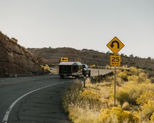
Highway 120 provides year-round access to Central Sierra Nevada Mountains. The highway traverses the southern portion of the Stanislaus National Forest, between the elevations of 2,800 and 4,700 feet. The highway continues through Yosemite National Park, eventually reaching an elevation of 9,943 feet at Tioga Pass, which is subject to annual winter closure. The Groveland Ranger District encompasses the Highway 120 corridor on the Stanislaus National Forest. For the most current information please call the Groveland Ranger District at (209) 962-7825, or stop by our office on Highway 120.
RV Road Trip Guides
Location
Highway 120 Corridor is located in California
Directions
Click here for a larger interactive map Highway 120 and the Groveland Ranger District
Coordinates
37.82660027 N
119.97500018 W
Connectivity
- T-MobileNo CoverageVerified by 2 usersLast on 2/5/26
- VerizonLTESome CoverageVerified by 7 usersLast on 2/5/26
- AT&TNo CoverageVerified by 1 user
Connectivity
- T-MobileNo CoverageVerified by 2 usersLast on 2/5/26
- VerizonLTESome CoverageVerified by 7 usersLast on 2/5/26
- AT&TNo CoverageVerified by 1 user
Access
Site Types
- Tent Sites
Features
Drive Time
- 1 hr 26 min from Merced, CA
- 1 hr 35 min from Modesto, CA
- 1 hr 42 min from Stockton, CA
- 2 hrs 16 min from Fresno, CA


