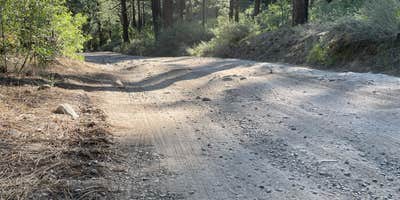
Lookout Campground sits at the end of an 8.5-mile dirt road through Toiyabe National Forest, requiring careful navigation over unmaintained sections with ruts and loose rocks. The US Forest Service manages this 20-site campground with sites priced from $6-$25 per night, accommodating RVs up to 50 feet alongside tent camping. Two vault toilets serve the loop, and water access requires a keyed handle that may not always be available to campers.
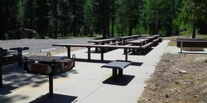
Sites spread across the forested loop with varying degrees of separation. Many offer substantial privacy between camping spots, while others sit closer together with just parking areas dividing them. Each site includes a picnic table and fire ring, with some featuring metal grates and cooking surfaces. Wood-bordered tent pads provide level ground in quieter corners of individual sites. An aspen grove runs through the campground, and campfires remain permitted with firewood collection allowed in designated areas.
The campground serves as a base for exploring Crystal Peak, where visitors can hike trails and search for crystals scattered across the landscape. Ray B. notes "the trail from the campground to Crystal Peak was great" and describes the area's mining history. Cell service reaches one bar intermittently for Verizon users, though hiking uphill toward the peak improves reception significantly.
Mid-week visits typically find only a few occupied sites among the 20 available. For campers wanting easier road access, Dog Valley offers another option 2.8 miles northeast.
Description
Overview
Lookout Campground is located on the California/Nevada border just west of Reno, Nevada. It sits at an elevation of 6,770 feet in a large aspen grove. It is not a highly developed campground, but it is considered a secret hideaway by those lucky enough to know about this remote gem.
Recreation
Adjacent to the campground is 'Crystal Peak', which can be accessed by vehicle or a short hike. This area is also popular for off-highway vehicles, wildlife viewing, and hunting opportunities.
Facilities
This campground has 17 first-come, first-served campsites (including two double sites) and one reservable group picnic area that can accommodate up to 100 people. Each campsite has a picnic table, fire ring, grill, and tent pad. There are four vault toilets and trash service. There are no electric hookups and no dump stations. Trailers and RVs should be limited to 15 feet in length (however, two sites could accommodate up to 30 foot lengths). To ensure that campfires are extinguished completely, there is non-potable water available on site (no drinking water available). Please bring your own firewood as none is available on site.
Natural Features
Visitors to this campground will be surrounded by a lush aspen, pine, and fir forest. Sites are well spaced to afford visitors plenty of privacy.
Nearby Attractions
Crystal Peak is known for its impressive crystal formations. Dog Valley and Peavine Mountain are popular off-highway vehicle and mountain biking areas. The American Discovery Trail also runs through this area.
RV Road Trip Guides

Map & DirectionsLookout Campground is located in California near Verdi
Directions
From Truckee, CA travel east on I-80. Take Exit 2 toward Verdi, NV. Turn right on 3rd St./US 40. Travel 1 mile then turn left on Bridge St. From Reno, NV travel west on I-80. Take Exit 5 toward Verdi, NV/State Route 425. Stay on Route 425 for 2.5 miles. Turn right on Bridge St. NOTE: Bridge Street has 2 one lane bridges with a maximum allowable height of 13 feet. Travel 0.6 miles on Bridge St, then turn right on Dog Valley Road. This road will turn into a dirt forest road (Road #002). Travel 7.2 miles. This road can be rough and often develops washboards. It can be navigated with 2-wheel drive (although low clearance vehicles are not recommended). Continue to follow signs to campground.
Address
1536 South Carson Street
Carson city, nevada, CA 89701
Coordinates
39.5888972 N
120.0736111 W
Connectivity
 T-MobileNo Coverage
 Verizon5GExcellent CoverageVerified by 1 userLast on 6/27/26
- AT&T5GExcellent Coverage
Connectivity
- T-MobileNo Coverage
- Verizon5GExcellent CoverageVerified by 1 userLast on 6/27/26
- AT&T5GExcellent Coverage
Access
- Drive-InPark next to your site
- Walk-InPark in a lot, walk to your site.
- Boat-InSites accessible by watercraft.
Site Types
- Tent Sites
- RV Sites
- Standard (Tent/RV)
- Group
- Equestrian
Features
For Campers
- Trash
- Picnic Table
- Firewood Available
- Phone Service
- WiFi
- Drinking Water
- Toilets
- Alcohol
- Pets
- Fires
For Vehicles
- Sanitary Dump
- Pull-Through Sites
- Big Rig Friendly


